

$3,200
/ Month
3003 Burleson Rd
Austin, TX 78741
Today
|
Edit
Favorites
512-461-5878
-
Bedrooms
3
-
Bathrooms
3
-
Square Feet
2,059 sq ft
-
Available
Available Now
Highlights
- Mature Trees
- Deck
- Wood Flooring
- Private Yard
- Multiple Living Areas
- 4 Car Detached Garage
3003 Burleson Rd

Favorites
Matterport 3D Tour
About This Home
Available Now
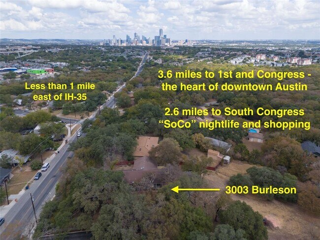
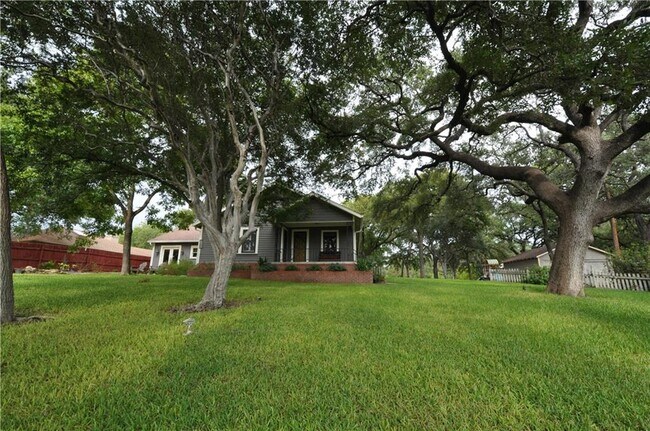
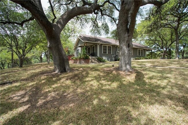
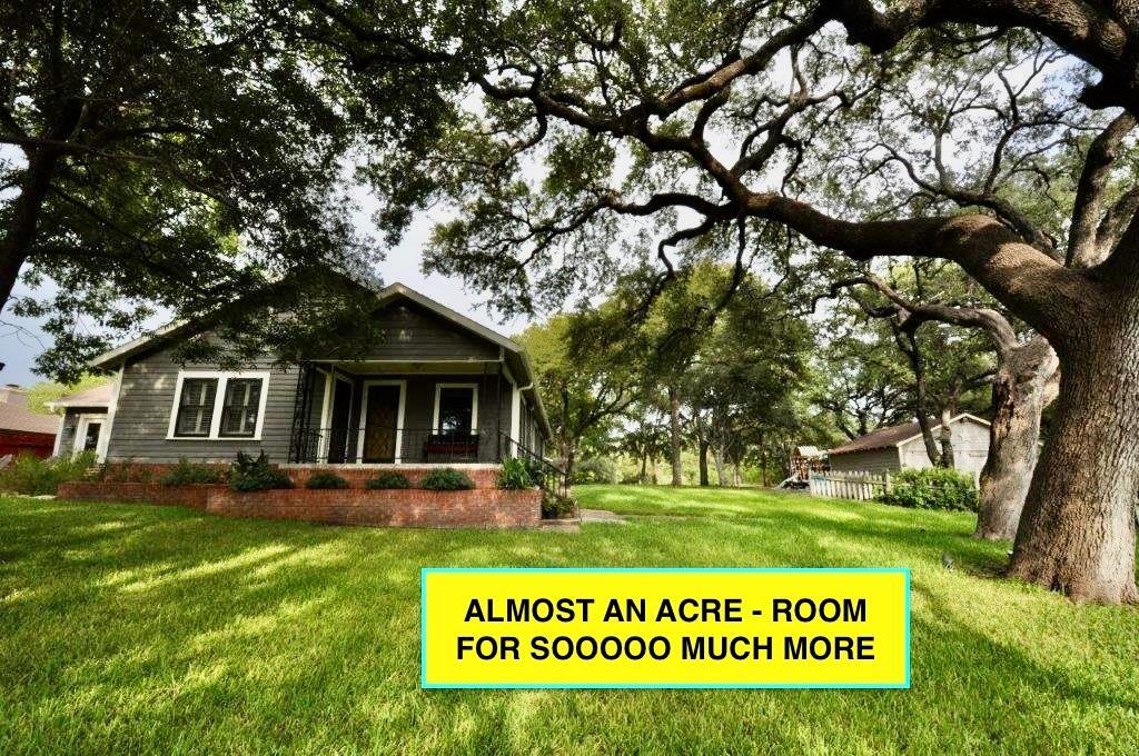
You are going to want to live at THE FUNKY FARMHOUSE! ALMOST AN ACRE sitting at the top of a hill and fully fenced - less than a mile east of IH-35 at St Edwards. On Burleson Road between Oltorf and Ben White / 71 - making it a snap to UT, downtown AND the airport too. Space to roam with large back deck, covered front porch AND back porch, soaring live oaks around the home and to the street for great privacy. Updated and beautiful three bedroom / three bath with two living areas. Great space to spread out and feel like you are in the country but oh-so-close to all the creature comforts of all that Austin has to offer. On city water but also has a water well for watering yard. Go to virtual tour link to see walk-through and floorplan view. Tenant and tenant’s agent to independently verify all information, including but not limited to lot size, zoning, restrictions, building capabilities, City of Austin protected trees, distances to locations, taxes, schools, etc. NOTE: A mix of older pics (with green grass!) - yard can be restored to former glory with use of well water! MLS ID 8117671
3003 Burleson Rd is a house located in Travis County and the 78741 ZIP Code. This area is served by the Austin Independent attendance zone.
* Price shown is base rent. Excludes user-selected optional fees and variable or usage-based fees and required charges due at or prior to move-in or at move-out. Price, availability, fees, and any applicable rent special are subject to change without notice.
* Square footage definitions vary. Displayed square footage is approximate.
Home Details
Home Type
Single Family Detached Home
Year Built
Built in 1946
Bedrooms and Bathrooms
3 Main Level Bedrooms
3 Full Bathrooms
Flooring
Wood
Carpet
Home Design
Composition Roof
HardiePlank Type
Pillar, Post or Pier Foundation
Slab Foundation
Interior Spaces
Multiple Living Areas
1-Story Property
Dining Area
2,059 Sq Ft Home
Kitchen
Microwave
Dishwasher
Self-Cleaning Oven
Listing and Financial Details
Security Deposit $3,600
12 Month Lease Term
$40 Application Fee
Assessor Parcel Number 3100503110000
Tenant pays for all utilities
Lot Details
0.85 Acre Lot
Mature Trees
Wooded Lot
Private Yard
Wood Fence
Chain Link Fence
Many Trees
Southwest Facing Home
Outdoor Features
Deck
Parking
4 Car Detached Garage
Schools
Linder Elementary School
Lively Middle School
Travis High School
Utilities
Central Heating and Cooling System
Above Ground Utilities
Community Details
Overview
No Home Owners Association
Polvado 02 Subdivision
Pet Policy
Dogs Allowed
Breed Restrictions
Medium pets allowed
Pet Deposit $300
Fees and Policies
The fees below are based on community-supplied data and may exclude additional fees and utilities.
-
Dogs
-
Allowed
-
Property Fee Disclaimer: Based on community-supplied data and independent market research. Subject to change without notice. May exclude fees for mandatory or optional services and usage-based utilities.
Contact
- Listed by Chrissy Hand | Coldwell Banker Realty
- Phone Number
- Website View Property Website
- Contact
-
Source
 Austin Board of REALTORS®
The information included in this listing is provided exclusively for consumers’ personal, non-commercial use and may not be used for any purpose other than to identify prospective properties consumers may be interested in purchasing. The information on each listing is furnished by the owner and deemed reliable to the best of his/her knowledge, but should be verified by the purchaser. ABoR, ACTRIS and Estately assume no responsibility for typographical errors, misprints or misinformation. This property listing is offered without respect to any protected classes in accordance with the law. Copyright © 2026.
Location
Get Directions
Amenities
- Dishwasher
- Microwave
- Refrigerator
- Hardwood Floors
- Carpet
Parker Lane is the ideal suburb with commuters. Not only is the neighborhood bounded by Interstate 35 and Highway 71, but the Austin-Bergstrom International Airport is five miles east, and Downtown Austin is five miles north. Whether you’re traveling into the city for work or play, or you’re planning some travel by air, Parker Lane is a premier place to put down roots.
If a quiet, affordable neighborhood is what you’re after, then look no further. Parker Lane is located directly east of Saint Edward’s University, and houses the Mabel Davis District Park, a sprawling area that’s home to one of Austin’s two skate parks, covering 12,000 square feet. Enjoy the park’s swimming pool, walking trails, basketball courts, and more!
Though the neighborhood is mainly residential, residents enjoy the variety of restaurants along Oltorf Street, along with the public bus stops, making getting around the area that much more convenient.
Learn more about living in Parker Lane
Education
| Colleges & Universities | Distance | ||
|---|---|---|---|
| Colleges & Universities | Distance | ||
| Drive: | 5 min | 2.3 mi | |
| Drive: | 8 min | 3.5 mi | |
| Drive: | 9 min | 4.5 mi | |
| Drive: | 9 min | 5.2 mi |
3003 Burleson Rd is within 5 minutes or 2.3 miles from St. Edward's University. It is also near Austin C.C., Riverside Campus and Austin C.C., Eastview Campus.
Schools


Public Elementary School
Grades PK-5
507 Students
Nearby
Charter Elementary School
Grades PK-5
362 Students
Nearby
Public Elementary School
Grades PK-5
557 Students
Attendance Zone
Public Middle School
Grades 6-8
1,107 Students
Attendance Zone
Public High School
Grades 9-12
1,137 Students
Attendance Zone
Private Elementary & Middle School
Grades PK-8
224 Students
Nearby
Private Elementary & Middle School
Grades PK-8
103 Students
Nearby
Private High School
Grades 9-12
150 Students
Nearby
School data provided by
 The GreatSchools Rating helps parents compare schools within a state based on a variety of school quality indicators and provides a helpful picture of how effectively each school serves all of its students. Ratings are on a scale of 1 (below average) to 10 (above average) and can include test scores, college readiness, academic progress, advanced courses, equity, discipline and attendance data. We also advise parents to visit schools, consider other information on school performance and programs, and consider family needs as part of the school selection process.
View GreatSchools Rating Methodology
Data provided by GreatSchools.org © 2026. All rights reserved.
View GreatSchools Rating Methodology
Data provided by GreatSchools.org © 2026. All rights reserved.
Transportation options available in Austin include Downtown Station, located 3.4 miles from 3003 Burleson Rd. 3003 Burleson Rd is near Austin-Bergstrom International, located 7.5 miles or 17 minutes away.
| Transit / Subway | Distance | ||
|---|---|---|---|
| Transit / Subway | Distance | ||
| Drive: | 6 min | 3.4 mi | |
| Drive: | 7 min | 4.1 mi | |
| Drive: | 10 min | 5.7 mi | |
| Drive: | 12 min | 8.1 mi | |
| Drive: | 15 min | 9.0 mi |
| Commuter Rail | Distance | ||
|---|---|---|---|
| Commuter Rail | Distance | ||
|
|
Drive: | 10 min | 5.0 mi |
|
|
Drive: | 35 min | 28.7 mi |
|
|
Drive: | 49 min | 39.1 mi |
| Airports | Distance | ||
|---|---|---|---|
| Airports | Distance | ||
|
Austin-Bergstrom International
|
Drive: | 17 min | 7.5 mi |
Time and distance from 3003 Burleson Rd.
| Shopping Centers | Distance | ||
|---|---|---|---|
| Shopping Centers | Distance | ||
| Walk: | 14 min | 0.7 mi | |
| Walk: | 15 min | 0.8 mi | |
| Walk: | 15 min | 0.8 mi |
3003 Burleson Rd has 3 shopping centers within 0.8 mile, which is about a 15-minute walk. The miles and minutes will be for the farthest away property.
| Parks and Recreation | Distance | ||
|---|---|---|---|
| Parks and Recreation | Distance | ||
|
Blunn Creek Nature Preserve
|
Drive: | 4 min | 1.8 mi |
|
Lady Bird Lake
|
Drive: | 5 min | 2.1 mi |
|
Umlauf Sculpture Garden and Museum
|
Drive: | 10 min | 4.5 mi |
|
Boggy Creek Greenbelt
|
Drive: | 9 min | 4.6 mi |
|
McKinney Falls State Park
|
Drive: | 13 min | 5.8 mi |
3003 Burleson Rd has 5 parks within 5.8 miles, including Blunn Creek Nature Preserve, Lady Bird Lake, and Boggy Creek Greenbelt.
| Hospitals | Distance | ||
|---|---|---|---|
| Hospitals | Distance | ||
| Drive: | 6 min | 3.7 mi | |
| Drive: | 6 min | 4.1 mi | |
| Drive: | 9 min | 5.6 mi |
3003 Burleson Rd has 3 hospitals within 5.6 miles, the nearest is St. David's South Austin Medical Center which is 3.7 miles away and a 6 minute drive.
| Military Bases | Distance | ||
|---|---|---|---|
| Military Bases | Distance | ||
| Drive: | 78 min | 63.6 mi | |
| Drive: | 107 min | 91.1 mi |
3003 Burleson Rd is 63.6 miles from Randolph Air Force Base, and is convenient to other military bases, including Camp Bullis Military Training Reservation.
You May Also Like
Similar Rentals Nearby
-

-

-
1 / 53

-
-
1 / 34

-
-
-

-

-


What Are Walk Score®, Transit Score®, and Bike Score® Ratings?
Walk Score® measures the walkability of any address. Transit Score® measures access to public transit. Bike Score® measures the bikeability of any address.
What is a Sound Score Rating?
A Sound Score Rating aggregates noise caused by vehicle traffic, airplane traffic and local sources
3003 Burleson Rd
Austin, TX 78741