
Presidential Towers
555 W Madison St,
Chicago, IL 60661
$1,698 - $6,620
Studio - 2 Beds
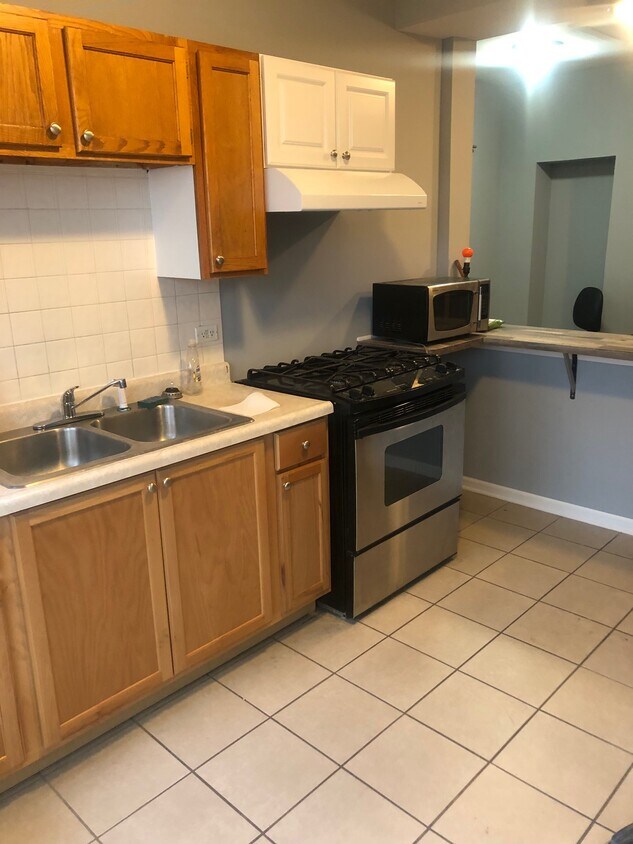

1 bedroom apartment for rent on the second floor. Extensively remodeled--new kitchen sink cabinet, stainless steel refrigerator, gas stove, new floors. Light fixtures w fan in bedroom. Freshly painted. Custom Bathroom with sliding glass door. Custom Built in kitchen table. 2 sofas, large screen TV in the bedroom. Renter to start an electric and gas account. Approximately 800 square feet. 1 vehicle parking. Perfect for the Professional. $ 1,200.00/month and $1,200.00 deposit. No pets.
3000-3006 N Cicero Ave is an apartment community located in Cook County and the 60641 ZIP Code. This area is served by the Chicago Public Schools attendance zone.
High Speed Internet Access
Microwave
Refrigerator
Tub/Shower
The Cragin neighborhood of Chicago, also known as Belmont-Cragin, sits halfway between Diversey and Fullerton Avenue, just over nine miles northwest of Downtown Chicago. Sitting eight miles northwest of the Loop, Cragin, once a hub of Chicago industry, now combines a suburban pace of life with urban conveniences. Locally owned restaurants, bars, and coffee shops are scattered around the neighborhood’s walkable layout. Contemporary apartment developments have popped up as more residents flock to areas outside Chicago. You’ll find mid-rise apartments in modern styles and long-standing rentals as well. Access to Interstate 90 and Chicago’s Blue Line makes it easy to commute into and out of the city.
Learn more about living in CraginCompare neighborhood and city base rent averages by bedroom.
| Cragin | Chicago, IL | |
|---|---|---|
| Studio | $858 | $1,656 |
| 1 Bedroom | $896 | $2,054 |
| 2 Bedrooms | $1,323 | $2,601 |
| 3 Bedrooms | $1,819 | $3,112 |
| Colleges & Universities | Distance | ||
|---|---|---|---|
| Colleges & Universities | Distance | ||
| Drive: | 7 min | 3.4 mi | |
| Drive: | 9 min | 4.1 mi | |
| Drive: | 10 min | 4.8 mi | |
| Drive: | 11 min | 5.3 mi |


Transportation options available in Chicago include Belmont Station (Blue Line), located 2.0 miles from 3000-3006 N Cicero Ave. 3000-3006 N Cicero Ave is near Chicago Midway International, located 10.4 miles or 21 minutes away, and Chicago O'Hare International, located 11.1 miles or 19 minutes away.
| Transit / Subway | Distance | ||
|---|---|---|---|
| Transit / Subway | Distance | ||
|
|
Drive: | 4 min | 2.0 mi |
|
|
Drive: | 4 min | 2.5 mi |
|
|
Drive: | 5 min | 2.7 mi |
|
|
Drive: | 6 min | 2.8 mi |
|
|
Drive: | 6 min | 3.0 mi |
| Commuter Rail | Distance | ||
|---|---|---|---|
| Commuter Rail | Distance | ||
|
|
Drive: | 3 min | 1.3 mi |
|
|
Drive: | 4 min | 1.5 mi |
|
|
Drive: | 4 min | 1.7 mi |
|
|
Drive: | 4 min | 2.1 mi |
|
|
Drive: | 5 min | 2.4 mi |
| Airports | Distance | ||
|---|---|---|---|
| Airports | Distance | ||
|
Chicago Midway International
|
Drive: | 21 min | 10.4 mi |
|
Chicago O'Hare International
|
Drive: | 19 min | 11.1 mi |
Scores provided by
Traffic
BusyAirport
CalmBusinesses
BusyScores provided by
HowLoud What is a Sound Score Rating? A Sound Score Rating aggregates noise caused by vehicle traffic, airplane traffic and local sources. How It WorksTime and distance from 3000-3006 N Cicero Ave.
| Shopping Centers | Distance | ||
|---|---|---|---|
| Shopping Centers | Distance | ||
| Walk: | 2 min | 0.1 mi | |
| Walk: | 6 min | 0.4 mi | |
| Walk: | 10 min | 0.5 mi |
| Parks and Recreation | Distance | ||
|---|---|---|---|
| Parks and Recreation | Distance | ||
|
Kilbourn Park
|
Walk: | 20 min | 1.0 mi |
|
LaFollette Park
|
Drive: | 6 min | 2.6 mi |
|
Riis Park
|
Drive: | 6 min | 2.7 mi |
|
Portage Park
|
Drive: | 6 min | 2.7 mi |
|
Wonder Works Children's Museum
|
Drive: | 8 min | 3.9 mi |
| Hospitals | Distance | ||
|---|---|---|---|
| Hospitals | Distance | ||
| Drive: | 3 min | 1.8 mi | |
| Drive: | 8 min | 3.8 mi | |
| Drive: | 9 min | 4.1 mi |
| Military Bases | Distance | ||
|---|---|---|---|
| Military Bases | Distance | ||
| Drive: | 27 min | 18.7 mi | |
| Drive: | 43 min | 28.0 mi | |
| Drive: | 54 min | 33.0 mi |
What Are Walk Score®, Transit Score®, and Bike Score® Ratings?
Walk Score® measures the walkability of any address. Transit Score® measures access to public transit. Bike Score® measures the bikeability of any address.
What is a Sound Score Rating?
A Sound Score Rating aggregates noise caused by vehicle traffic, airplane traffic and local sources.

3000-3006 N Cicero Ave
Chicago, IL 60641


