
$2,500
/ Month
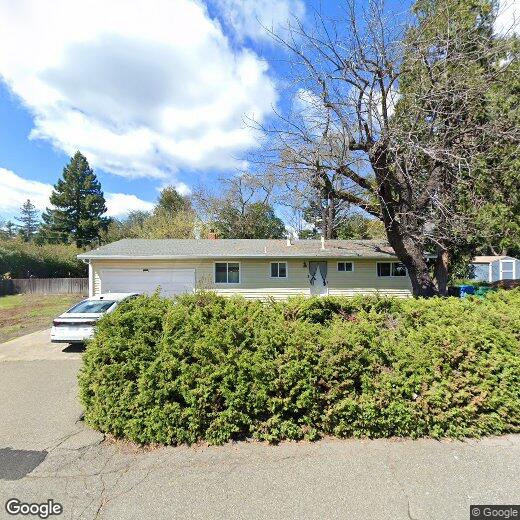
133 Randolph Ave
Kenwood, CA 95452
Favorites
133 Randolph Ave

Favorites
Check Back Soon for Upcoming Availability
| Beds | Baths | Average SF |
|---|---|---|
| 3 Bedrooms 3 Bedrooms 3 Br | 1 Bath 1 Bath 1 Ba | 1,120 SF |
About This Property
(707) 524-8380 x109 - Remodeled three bedroom home with HUGE yard! - This beautiful three bedroom one bathroom home has new dual pane windows, new carpet, new interior paint and remodeled bathroom. Has a very large front, side and back yard. Fireplace and wall heating. Electric cooktop and oven. Wood flooring in the kitchen and laminate wood in the bathroom. Refrigerator included but not warranted. Landscaping services included. Two car garage. Month to Month. (EE) (RLNE5037439)
133 Randolph Ave is an apartment community located in Sonoma County and the 95452 ZIP Code.
133 Randolph Ave,
Kenwood,
CA
95452
Education
| Colleges & Universities | Distance | ||
|---|---|---|---|
| Colleges & Universities | Distance | ||
| Drive: | 20 min | 11.4 mi | |
| Drive: | 31 min | 18.7 mi | |
| Drive: | 39 min | 25.6 mi | |
| Drive: | 54 min | 32.4 mi |
133 Randolph Ave is within 20 minutes or 11.4 miles from Santa Rosa Jr Coll.. It is also near Sonoma State University and Santa Rosa Jr Coll., Petaluma.
Walkability Near 133 Randolph Ave Kenwood, CA 95452
Getting Around
 What do Walkability, Transit, Drivability, and Bikeability mean?
Walkability measures the walking distance to day-to-day needs.
Transit measures access to public transportation.
Drivability measures congestion, parking availability, and access to major roads.
Bikeability measures the suitability for cycling.
How It Works
What do Walkability, Transit, Drivability, and Bikeability mean?
Walkability measures the walking distance to day-to-day needs.
Transit measures access to public transportation.
Drivability measures congestion, parking availability, and access to major roads.
Bikeability measures the suitability for cycling.
How It Works
Somewhat Walkable
Walkability
20
/ 100
Limited Public Transit
Transit
30
/ 100
Very Drivable
Drivability
80
/ 100
Somewhat Bikeable
Bikeability
30
/ 100
Scores provided by
-
Soundscore™
-
/ 100
Traffic
-Airport
-Businesses
-Scores provided by
HowLoud What is a Sound Score Rating? A Sound Score Rating aggregates noise caused by vehicle traffic, airplane traffic and local sources. How It WorksYou May Also Like
Similar Rentals Nearby
-
-
-
3 Beds$3,186Total Monthly PriceTotal Monthly Price NewPrices include base rent and required monthly fees of $5. Variable costs based on usage may apply.Base Rent:3 Beds$3,180Specials
Pets Allowed Fitness Center In Unit Washer & Dryer Walk-In Closets Clubhouse Microwave Stainless Steel Appliances
-
-
-
-
-
-
-


What Are Walk Score®, Transit Score®, and Bike Score® Ratings?
Walk Score® measures the walkability of any address. Transit Score® measures access to public transit. Bike Score® measures the bikeability of any address.
What is a Sound Score Rating?
A Sound Score Rating aggregates noise caused by vehicle traffic, airplane traffic and local sources.
133 Randolph Ave
Kenwood, CA 95452