
Presidential Towers
555 W Madison St,
Chicago, IL 60661
$1,631 - $6,387
Studio - 2 Beds
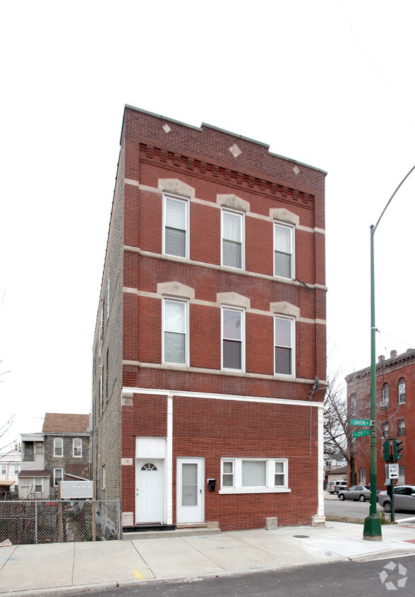
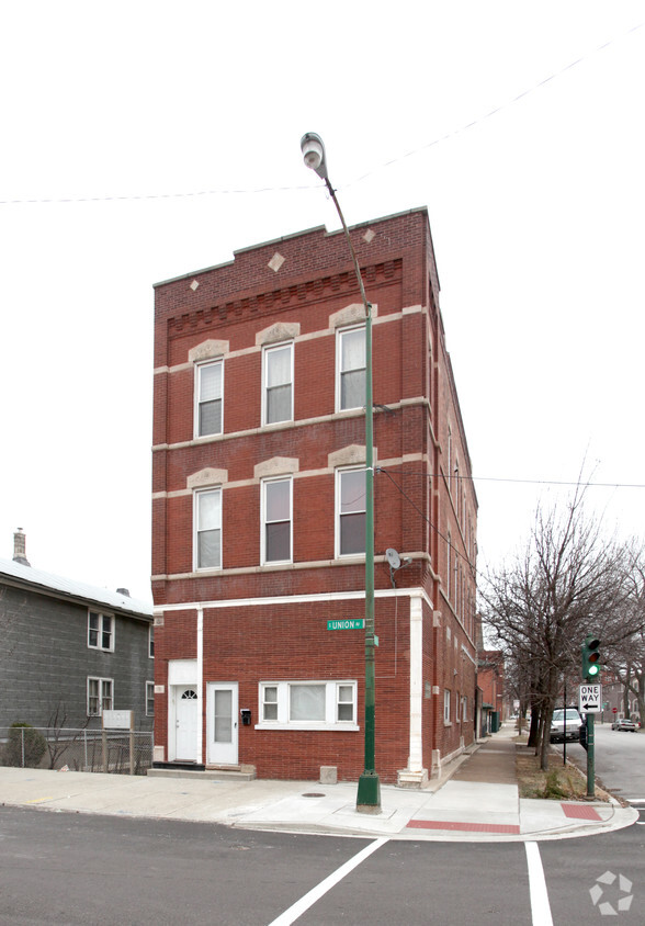

2859 S Union Ave in Chicago is ready for your visit. The location in Chicago's 60616 area is an ideal place to live. The community staff is ready for you to come for a visit. Come by to check out the current floorplan options. Make your move to 2859 S Union Ave. Contact or drop by to schedule a tour today.
2859 S Union Ave is an apartment community located in Cook County and the 60616 ZIP Code. This area is served by the Chicago Public Schools attendance zone.
Situated on the South Side of Chicago, Bridgeport combines a passion for city politics with the excitement of baseball. Bridgeport has been the home or birthplace of five Chicago mayors, and sits adjacent to Guaranteed Rate Field—home of the legendary Chicago White Sox, an MLB team dating back to 1901.
Tasty eateries, convenient shops, and diverse markets line West 31st Street and South Halsted Street in the heart of Bridgeport. The 27-acre Palmisano Park provides plenty of space for outdoor activities along with breathtaking city views.
The Dan Ryan Expressway and I-55, located on the eastern side of the neighborhood, connects residents to Downtown Chicago, the south suburbs, and beyond. For those who prefer to take the train, the CTA Red Line offers quick service for the 4.4-mile ride.
Learn more about living in BridgeportCompare neighborhood and city base rent averages by bedroom.
| Bridgeport | Chicago, IL | |
|---|---|---|
| Studio | - | $1,644 |
| 1 Bedroom | $1,479 | $2,046 |
| 2 Bedrooms | $1,024 | $2,581 |
| 3 Bedrooms | $1,881 | $3,091 |
| Colleges & Universities | Distance | ||
|---|---|---|---|
| Colleges & Universities | Distance | ||
| Drive: | 4 min | 1.5 mi | |
| Drive: | 6 min | 2.6 mi | |
| Drive: | 6 min | 2.7 mi | |
| Drive: | 6 min | 3.1 mi |

Transportation options available in Chicago include Halsted Station (Orange Line), located 0.6 mile from 2859 S Union Ave. 2859 S Union Ave is near Chicago Midway International, located 7.4 miles or 15 minutes away, and Chicago O'Hare International, located 20.0 miles or 32 minutes away.
| Transit / Subway | Distance | ||
|---|---|---|---|
| Transit / Subway | Distance | ||
|
|
Walk: | 11 min | 0.6 mi |
|
|
Drive: | 3 min | 1.5 mi |
|
|
Drive: | 4 min | 1.7 mi |
|
|
Drive: | 4 min | 1.8 mi |
|
|
Drive: | 5 min | 2.8 mi |
| Commuter Rail | Distance | ||
|---|---|---|---|
| Commuter Rail | Distance | ||
|
|
Drive: | 4 min | 1.5 mi |
| Drive: | 3 min | 1.5 mi | |
|
|
Drive: | 6 min | 2.0 mi |
|
|
Drive: | 8 min | 3.1 mi |
|
|
Drive: | 8 min | 3.2 mi |
| Airports | Distance | ||
|---|---|---|---|
| Airports | Distance | ||
|
Chicago Midway International
|
Drive: | 15 min | 7.4 mi |
|
Chicago O'Hare International
|
Drive: | 32 min | 20.0 mi |
Scores provided by
Traffic
-Airport
-Businesses
-Scores provided by
HowLoud What is a Sound Score Rating? A Sound Score Rating aggregates noise caused by vehicle traffic, airplane traffic and local sources. How It WorksTime and distance from 2859 S Union Ave.
| Shopping Centers | Distance | ||
|---|---|---|---|
| Shopping Centers | Distance | ||
| Walk: | 7 min | 0.4 mi | |
| Drive: | 3 min | 1.5 mi |
| Parks and Recreation | Distance | ||
|---|---|---|---|
| Parks and Recreation | Distance | ||
|
Dunbar Park
|
Drive: | 3 min | 1.5 mi |
|
Women's Park and Gardens
|
Drive: | 5 min | 2.2 mi |
|
Ellis Park
|
Drive: | 6 min | 2.7 mi |
|
Fuller Park
|
Drive: | 6 min | 2.9 mi |
|
Field Museum of Natural History
|
Drive: | 7 min | 3.2 mi |
| Hospitals | Distance | ||
|---|---|---|---|
| Hospitals | Distance | ||
| Drive: | 3 min | 1.4 mi | |
| Drive: | 7 min | 3.3 mi | |
| Drive: | 9 min | 3.9 mi |
| Military Bases | Distance | ||
|---|---|---|---|
| Military Bases | Distance | ||
| Drive: | 40 min | 27.6 mi | |
| Drive: | 46 min | 31.3 mi | |
| Drive: | 57 min | 36.4 mi |
What Are Walk Score®, Transit Score®, and Bike Score® Ratings?
Walk Score® measures the walkability of any address. Transit Score® measures access to public transit. Bike Score® measures the bikeability of any address.
What is a Sound Score Rating?
A Sound Score Rating aggregates noise caused by vehicle traffic, airplane traffic and local sources.


