
$2,200
Total Monthly Price
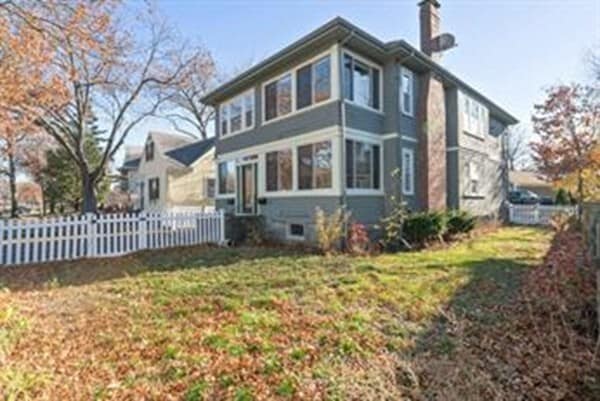
280 Furnace Brook Pkwy Unit 1
Quincy, MA 02169
2 Weeks Ago
|
Edit
Favorites
280 Furnace Brook Pkwy Unit 1

Favorites
Check Back Soon for Upcoming Availability
| Beds | Baths | Average SF |
|---|---|---|
| 2 Bedrooms 2 Bedrooms 2 Br | 1 Bath 1 Bath 1 Ba | 1,000 SF |
About This Property
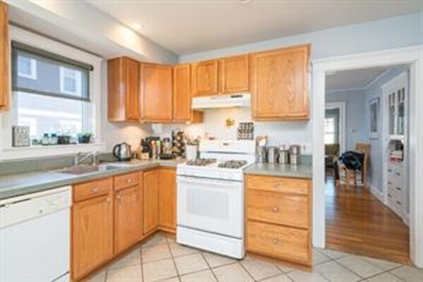
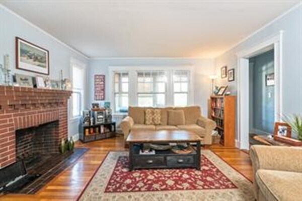
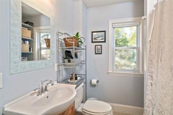
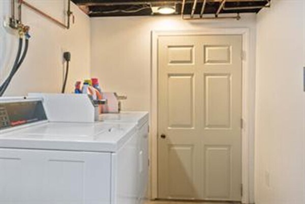
This is a great Quincy Area. Located across the Black Rock Creek-The unit is1000 s.f. on 1st floor 2 bd.rm. Modern,fully appliance kitchen and updated bath. Beautiful hardwood floors throughout. Decorative Living room Fireplace. French Doors. Both bedroom are spacious. 2 Off-street parking for two cars. Coin-op washer and dryer will be available to use in basement. Less than 10min walk to Quincy Center Redline T-Station. Nicely located to Downtown Boston and easy access to all major roadways,shopping,restaurants,beach and more. Sorry No Pets and Non-Smokers. Tenant pays all utilities. Available April 1,2024.
280 Furnace Brook Pkwy is an apartment community located in Norfolk County and the 02169 ZIP Code.
280 Furnace Brook Pkwy,
Quincy,
MA
02169
Quincy Center covers the historic downtown district of Quincy, Massachusetts. Known as the “City of Presidents,” Quincy boasts unique shops, local restaurants, and admired historic sites. In fact, Quincy Center houses the United States First Parish Church, which is the location of both President John Adams and his son, President John Quincy Adams’ burial sites.
If you become a resident of this vibrant town, you can visit the Adams’ birthplaces and explore their historic homes, which are the oldest presidential birthplaces in the country. If you’re a political history buff, Quincy Center is the place for you! With an abundance of upscale apartments and the occasional historic house, condo, and townhome, finding your perfect rental in this area should be a breeze.
A coastal neighborhood situated on Quincy Bay, Quincy Center is just 10 miles south of Downtown Boston.
Learn more about living in Quincy CenterBelow are rent ranges for similar nearby apartments
| Beds | Average Size | Lowest | Typical | Premium |
|---|---|---|---|---|
| Studio Studio Studio | 414-415 Sq Ft | $1,550 | $2,174 | $3,549 |
| 1 Bed 1 Bed 1 Bed | 739-742 Sq Ft | $1,800 | $2,699 | $6,700 |
| 2 Beds 2 Beds 2 Beds | 1051-1054 Sq Ft | $1,895 | $3,225 | $5,960 |
| 3 Beds 3 Beds 3 Beds | 1151 Sq Ft | $2,695 | $3,239 | $3,900 |
| 4 Beds 4 Beds 4 Beds | 1443 Sq Ft | $2,600 | — | — |
Education
| Colleges & Universities | Distance | ||
|---|---|---|---|
| Colleges & Universities | Distance | ||
| Drive: | 12 min | 5.7 mi | |
| Drive: | 16 min | 7.0 mi | |
| Drive: | 15 min | 8.1 mi | |
| Drive: | 16 min | 8.2 mi |
280 Furnace Brook Pkwy Unit 1 is within 12 minutes or 5.7 miles from UMass Boston. It is also near Curry College and Northeastern University.
Transportation options available in Quincy include Wollaston Station, located 1.2 miles from 280 Furnace Brook Pkwy Unit 1. 280 Furnace Brook Pkwy Unit 1 is near General Edward Lawrence Logan International, located 11.1 miles or 20 minutes away.
| Transit / Subway | Distance | ||
|---|---|---|---|
| Transit / Subway | Distance | ||
|
|
Drive: | 2 min | 1.2 mi |
|
|
Drive: | 5 min | 2.3 mi |
|
|
Drive: | 5 min | 2.5 mi |
|
|
Drive: | 8 min | 4.1 mi |
|
|
Drive: | 8 min | 4.4 mi |
| Commuter Rail | Distance | ||
|---|---|---|---|
| Commuter Rail | Distance | ||
|
|
Walk: | 18 min | 0.9 mi |
| Drive: | 8 min | 3.9 mi | |
|
|
Drive: | 8 min | 4.4 mi |
|
|
Drive: | 9 min | 5.2 mi |
| Drive: | 11 min | 5.8 mi |
| Airports | Distance | ||
|---|---|---|---|
| Airports | Distance | ||
|
General Edward Lawrence Logan International
|
Drive: | 20 min | 11.1 mi |
Walkability Near 280 Furnace Brook Pkwy Quincy, MA 02169
Getting Around
 What do Walkability, Transit, Drivability, and Bikeability mean?
Walkability measures the walking distance to day-to-day needs.
Transit measures access to public transportation.
Drivability measures congestion, parking availability, and access to major roads.
Bikeability measures the suitability for cycling.
How It Works
What do Walkability, Transit, Drivability, and Bikeability mean?
Walkability measures the walking distance to day-to-day needs.
Transit measures access to public transportation.
Drivability measures congestion, parking availability, and access to major roads.
Bikeability measures the suitability for cycling.
How It Works
Moderately Walkable
Walkability
60
/ 100
Some Public Transit
Transit
50
/ 100
Very Drivable
Drivability
80
/ 100
Moderately Bikeable
Bikeability
60
/ 100
Scores provided by
-
Soundscore™
-
/ 100
Traffic
-Airport
-Businesses
-Scores provided by
HowLoud What is a Sound Score Rating? A Sound Score Rating aggregates noise caused by vehicle traffic, airplane traffic and local sources. How It WorksTime and distance from 280 Furnace Brook Pkwy Unit 1.
| Shopping Centers | Distance | ||
|---|---|---|---|
| Shopping Centers | Distance | ||
| Walk: | 18 min | 0.9 mi | |
| Drive: | 3 min | 1.3 mi | |
| Drive: | 3 min | 1.6 mi |
280 Furnace Brook Pkwy Unit 1 has 3 shopping centers within 1.6 miles, which is about a 3-minute drive. The miles and minutes will be for the farthest away property.
| Parks and Recreation | Distance | ||
|---|---|---|---|
| Parks and Recreation | Distance | ||
|
Adams National Historical Park
|
Walk: | 14 min | 0.7 mi |
|
Squantum Point Park
|
Drive: | 10 min | 3.8 mi |
|
Webb Memorial State Park
|
Drive: | 11 min | 5.4 mi |
|
Dorchester Shores Reservation
|
Drive: | 11 min | 5.7 mi |
|
Franklin Park Zoo
|
Drive: | 13 min | 7.0 mi |
280 Furnace Brook Pkwy Unit 1 has 5 parks within 7.0 miles, including Adams National Historical Park, Squantum Point Park, and Webb Memorial State Park.
| Hospitals | Distance | ||
|---|---|---|---|
| Hospitals | Distance | ||
| Drive: | 8 min | 4.3 mi | |
| Drive: | 8 min | 4.5 mi | |
| Drive: | 12 min | 7.2 mi |
280 Furnace Brook Pkwy Unit 1 has 3 hospitals within 7.2 miles, the nearest is Beth Israel Deaconess Hospital - Milton which is 4.3 miles away and a 8 minute drive.
You May Also Like
-
Washington Crossing Apartments
55 Cedar St
Woburn, MA 01801
$2,997 - $3,993 Plus Fees
2 Br 17.3 mi
-
The Point at Woburn
120 Commerce Way
Woburn, MA 01801
$2,711 - $6,067 Total Monthly Price
2 Br 19.0 mi
-
Station 316 Apartments
316 New Boston St
Woburn, MA 01801
$2,765 - $6,075 Total Monthly Price
2-3 Br 19.5 mi
Similar Rentals Nearby
-
-
-
-
2 Beds$2,788+3 Beds$3,428+Total Monthly PriceTotal Monthly Price NewPrices include base rent and required monthly fees. Variable costs based on usage may apply.
Pets Allowed Fitness Center Pool Dishwasher Kitchen In Unit Washer & Dryer
-
2 Beds$5,632+Total Monthly PriceTotal Monthly Price NewPrices include required monthly fees of $10 - $15.Base Rent:2 Beds$5,622+
Pets Allowed Fitness Center In Unit Washer & Dryer High-Speed Internet Stainless Steel Appliances Package Service
-
2 Beds$2,910+Total Monthly PriceTotal Monthly Price NewPrices include base rent and required monthly fees. Variable costs based on usage may apply.Specials
Pets Allowed Fitness Center Dishwasher Refrigerator Kitchen In Unit Washer & Dryer
-
-
Plus Fees2 Beds$4,095+3 Beds$8,350+1 Month Free
Pets Allowed Fitness Center Pool Dishwasher Refrigerator Kitchen
-
2 Beds$2,748+Total Monthly PriceTotal Monthly Price NewPrices include base rent and required monthly fees of $8. Variable costs based on usage may apply.Base Rent:2 Beds$2,740+1 Month Free
Fitness Center Clubhouse Balcony Granite Countertops Smoke Free Basketball Court
-
2 Beds$3,139+Total Monthly PriceTotal Monthly Price NewPrices include required monthly fees of $130.Base Rent:2 Beds$3,009+2 Months Free
Pets Allowed Fitness Center Pool Walk-In Closets Business Center Package Service Elevator


What Are Walk Score®, Transit Score®, and Bike Score® Ratings?
Walk Score® measures the walkability of any address. Transit Score® measures access to public transit. Bike Score® measures the bikeability of any address.
What is a Sound Score Rating?
A Sound Score Rating aggregates noise caused by vehicle traffic, airplane traffic and local sources.
280 Furnace Brook Pkwy
Quincy, MA 02169