$3,195 / Month
280 Easy St Unit 417
Mountain View, CA 94043
1 Day Ago
Favorites
408-440-6359
-
Bedrooms
2
-
Bathrooms
1
-
Square Feet
894 sq ft
-
Available
Available Now
280 Easy St Unit 417

Favorites
About This Home
$3,195 deposit,
Available Now
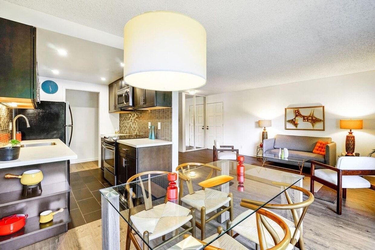
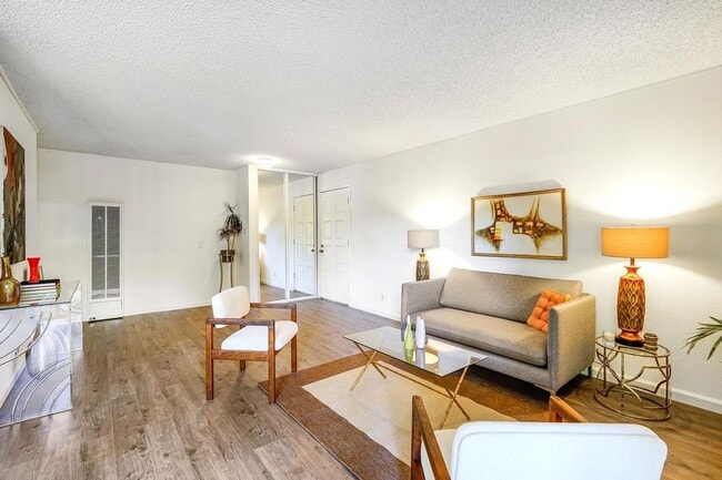
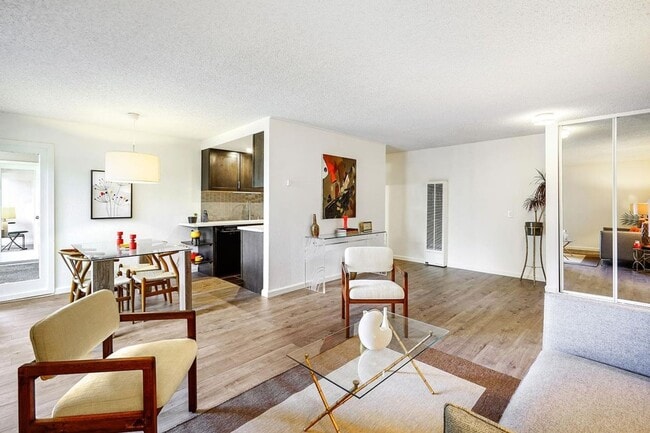
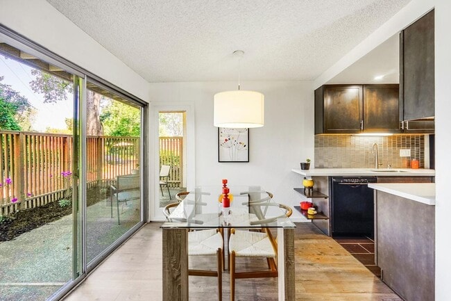
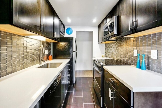
Welcome to this ground floor, updated, contemporary condo featuring NEW: front door hardware, LED lighting, bathroom fixtures, flooring & fresh paint throughout. In-house laundry can be added. New wall-to-wall carpet spans the living room, hallway & bedrooms, while new vinyl adorns the kitchen & bathroom floors. Mirrored wardrobe closet doors & floor-to-ceiling windows flood the space with natural light. Three oversized sliding glass doors leading to the patio offer tranquil views of the walls of greenery surrounding the patio railings, creating total privacy. The covered patio provides a perfect spot to unwind and take in the peaceful ambiance. There is one assigned, covered parking space, a large, assigned, private storage locker, and open guest parking spaces. Mature trees & lush green spaces are found throughout the property. A sparkling pool, spa & community room are at the center of it all, providing a perfect setting for relaxation & entertainment. Nearby is access to the Stevens Creek Trail, Creekside Park & beautiful Whisman Park with playground & tennis courts. Only a couple miles away is Mt. View's vibrant Castro St. with many restaurants, cafes & shops. Convenient access to highways 85, 101, 237, Central Expwy. & only 1 mile to the Mountain View Caltrain Station.
280 Easy St is an apartment community located in Santa Clara County and the 94043 ZIP Code.
* Price shown is base rent and may not include non-optional fees and utilities.
Price, availability, fees, and any applicable rent special are subject to change without notice.
* Square footage definitions vary. Displayed square footage is approximate.
Features
- Dishwasher
Contact
- Listed by National CPM, Inc. | National CPM, Inc.
- Phone Number
- Contact
Location
Get Directions
Amenities
- Dishwasher
Known for its fantastic views of the Santa Cruz Mountains, the Wagon Wheel neighborhood of Mountain View, California lies 12 miles southeast of Palo Alto via US-101S. Residents of Wagon Wheel's apartments and home rentals enjoy convenient transportation via light rail, bus, and private shuttle. Featuring an online chat group, this community values resident participation in planning activities such as ice cream socials, community breakfasts, and pumpkin festivals at the local park.
Two parks serve this neighborhood where residents can picnic, relax in an arbor, or join a pick-up baseball game. Whisman Park provides access to the Stevens Creek Trail, with its paved paths for walking, biking, or jogging through scenic natural areas.
Learn more about living in Wagon Wheel
Education
| Colleges & Universities | Distance | ||
|---|---|---|---|
| Colleges & Universities | Distance | ||
| Drive: | 7 min | 3.5 mi | |
| Drive: | 14 min | 5.8 mi | |
| Drive: | 17 min | 7.1 mi | |
| Drive: | 11 min | 7.3 mi |
280 Easy St Unit 417 is within 7 minutes or 3.5 miles from Foothill College, Middlefield. It is also near Foothill Coll., Los Altos and De Anza College.
Transportation options available in Mountain View include Whisman Station, located 0.8 mile from 280 Easy St Unit 417. 280 Easy St Unit 417 is near Norman Y Mineta San Jose International, located 9.1 miles or 14 minutes away, and San Francisco International, located 25.4 miles or 32 minutes away.
| Transit / Subway | Distance | ||
|---|---|---|---|
| Transit / Subway | Distance | ||
| Walk: | 15 min | 0.8 mi | |
| Walk: | 16 min | 0.8 mi | |
| Walk: | 18 min | 0.9 mi | |
| Walk: | 18 min | 0.9 mi | |
|
|
Walk: | 18 min | 1.0 mi |
| Commuter Rail | Distance | ||
|---|---|---|---|
| Commuter Rail | Distance | ||
| Drive: | 6 min | 2.2 mi | |
| Drive: | 5 min | 2.3 mi | |
| Drive: | 7 min | 3.0 mi | |
| Drive: | 7 min | 3.6 mi | |
| Drive: | 10 min | 4.9 mi |
| Airports | Distance | ||
|---|---|---|---|
| Airports | Distance | ||
|
Norman Y Mineta San Jose International
|
Drive: | 14 min | 9.1 mi |
|
San Francisco International
|
Drive: | 32 min | 25.4 mi |
Time and distance from 280 Easy St Unit 417.
| Shopping Centers | Distance | ||
|---|---|---|---|
| Shopping Centers | Distance | ||
| Walk: | 14 min | 0.8 mi | |
| Drive: | 3 min | 1.3 mi | |
| Drive: | 5 min | 2.1 mi |
280 Easy St Unit 417 has 3 shopping centers within 2.1 miles, which is about a 5-minute walk. The miles and minutes will be for the farthest away property.
| Parks and Recreation | Distance | ||
|---|---|---|---|
| Parks and Recreation | Distance | ||
|
Stevens Creek Shoreline Nature Study Area
|
Drive: | 8 min | 3.3 mi |
|
J. Pearce Mitchell Park
|
Drive: | 10 min | 4.3 mi |
|
Terman Park
|
Drive: | 10 min | 4.7 mi |
|
Esther Clark Nature Preserve
|
Drive: | 13 min | 5.8 mi |
|
Redwood Grove
|
Drive: | 13 min | 6.0 mi |
280 Easy St Unit 417 has 5 parks within 6.0 miles, including Stevens Creek Shoreline Nature Study Area, J. Pearce Mitchell Park, and Terman Park.
| Hospitals | Distance | ||
|---|---|---|---|
| Hospitals | Distance | ||
| Drive: | 6 min | 2.8 mi | |
| Drive: | 13 min | 8.3 mi | |
| Drive: | 14 min | 8.5 mi |
280 Easy St Unit 417 has 3 hospitals within 8.5 miles, the nearest is El Camino Hospital which is 2.8 miles away and a 6 minute drive.
| Military Bases | Distance | ||
|---|---|---|---|
| Military Bases | Distance | ||
| Drive: | 7 min | 2.4 mi |
280 Easy St Unit 417 is 2.4 miles and a 7 minute drive from Ames Research Center.
You May Also Like
Similar Rentals Nearby


What Are Walk Score®, Transit Score®, and Bike Score® Ratings?
Walk Score® measures the walkability of any address. Transit Score® measures access to public transit. Bike Score® measures the bikeability of any address.
What is a Sound Score Rating?
A Sound Score Rating aggregates noise caused by vehicle traffic, airplane traffic and local sources

280 Easy St
Mountain View, CA 94043