
The Vitagraph
1277 E 14th St,
Brooklyn, NY 11230
$2,599 - $4,308
1-3 Beds
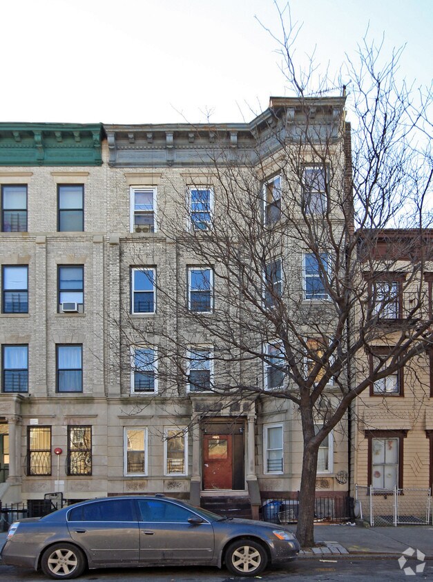
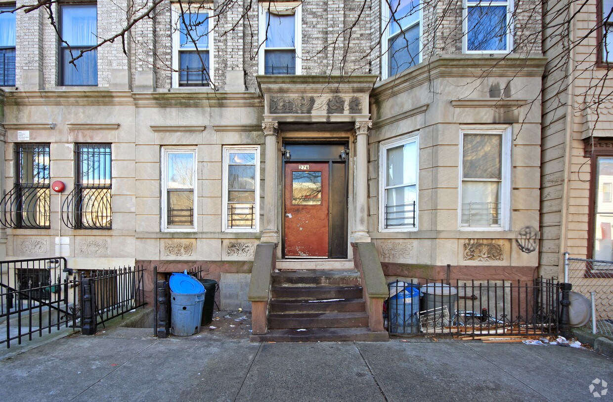
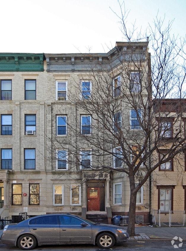
Experience Brooklyn living at 276 Marion St. This community can be found on Marion St. in the 11233 area of Brooklyn. Here at this community, the professional leasing staff is ready to help you in finding your perfect fit. Come by to check out the current floorplan options. Start living the good life at 276 Marion St. Stop by the leasing office to schedule a tour today.
276 Marion St is an apartment community located in Kings County and the 11233 ZIP Code. This area is served by the New York City Geographic District #23 attendance zone.
Bedford-Stuyvesant, often shortened to Bed-Stuy, sits in north central Brooklyn, touting plenty of classic brownstones along tree-lined streets. Bed-Stuy is revered for its historic architecture, containing one of the highest concentrations of Victorian properties in all of New York City.
Residents enjoy a strong sense of community in Bed-Stuy along with an array of diverse eateries, cafes, and bodegas. Herbert Von King Park lies at the center of the neighborhood, exuding a lively town-square atmosphere with an outdoor amphitheater, Cultural Arts Center, and athletic facilities. Convenience to public transportation and I-278 makes commuting and traveling from Bed-Stuy a breeze.
Learn more about living in Bedford StuyvesantCompare neighborhood and city base rent averages by bedroom.
| Bedford-Stuyvesant | Brooklyn, NY | |
|---|---|---|
| Studio | $2,243 | $2,684 |
| 1 Bedroom | $2,662 | $3,036 |
| 2 Bedrooms | $3,196 | $3,956 |
| 3 Bedrooms | $3,989 | $4,926 |
| Colleges & Universities | Distance | ||
|---|---|---|---|
| Colleges & Universities | Distance | ||
| Drive: | 9 min | 3.0 mi | |
| Drive: | 9 min | 3.0 mi | |
| Drive: | 8 min | 3.2 mi | |
| Drive: | 10 min | 3.8 mi |


Transportation options available in Brooklyn include Ralph Avenue, located 0.3 mile from 276 Marion St. 276 Marion St is near LaGuardia, located 8.8 miles or 20 minutes away, and John F Kennedy International, located 9.7 miles or 19 minutes away.
| Transit / Subway | Distance | ||
|---|---|---|---|
| Transit / Subway | Distance | ||
|
|
Walk: | 5 min | 0.3 mi |
|
|
Walk: | 9 min | 0.5 mi |
|
|
Walk: | 10 min | 0.5 mi |
|
|
Walk: | 10 min | 0.5 mi |
|
|
Walk: | 13 min | 0.7 mi |
| Commuter Rail | Distance | ||
|---|---|---|---|
| Commuter Rail | Distance | ||
|
|
Drive: | 3 min | 1.3 mi |
|
|
Drive: | 6 min | 2.0 mi |
|
|
Drive: | 9 min | 3.3 mi |
|
|
Drive: | 16 min | 5.4 mi |
|
|
Drive: | 15 min | 6.2 mi |
| Airports | Distance | ||
|---|---|---|---|
| Airports | Distance | ||
|
LaGuardia
|
Drive: | 20 min | 8.8 mi |
|
John F Kennedy International
|
Drive: | 19 min | 9.7 mi |
Scores provided by
Traffic
-Airport
-Businesses
-Scores provided by
HowLoud What is a Sound Score Rating? A Sound Score Rating aggregates noise caused by vehicle traffic, airplane traffic and local sources. How It WorksTime and distance from 276 Marion St.
| Shopping Centers | Distance | ||
|---|---|---|---|
| Shopping Centers | Distance | ||
| Drive: | 6 min | 1.9 mi | |
| Drive: | 5 min | 2.4 mi |
| Parks and Recreation | Distance | ||
|---|---|---|---|
| Parks and Recreation | Distance | ||
|
St. John's Park
|
Drive: | 4 min | 1.2 mi |
|
Betsy Head Memorial Playground
|
Drive: | 6 min | 1.7 mi |
|
Brooklyn Children's Museum
|
Drive: | 6 min | 1.8 mi |
|
Maria Hernandez Park
|
Drive: | 6 min | 2.1 mi |
|
Highland Park Childrens Garden
|
Drive: | 5 min | 2.1 mi |
| Hospitals | Distance | ||
|---|---|---|---|
| Hospitals | Distance | ||
| Drive: | 3 min | 1.2 mi | |
| Drive: | 5 min | 2.0 mi | |
| Drive: | 6 min | 2.3 mi |
| Military Bases | Distance | ||
|---|---|---|---|
| Military Bases | Distance | ||
| Drive: | 18 min | 8.3 mi | |
| Drive: | 22 min | 8.5 mi | |
| Drive: | 26 min | 9.8 mi |
What Are Walk Score®, Transit Score®, and Bike Score® Ratings?
Walk Score® measures the walkability of any address. Transit Score® measures access to public transit. Bike Score® measures the bikeability of any address.
What is a Sound Score Rating?
A Sound Score Rating aggregates noise caused by vehicle traffic, airplane traffic and local sources.
276 Marion St
Brooklyn, NY 11233


