
$3,200
/ Month
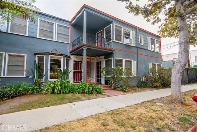
265 N Swall Dr
Beverly Hills, CA 90211
Today
|
Edit
Favorites
818-201-8506
-
Bedrooms
1
-
Bathrooms
1
-
Square Feet
900 sq ft
-
Available
Available Now
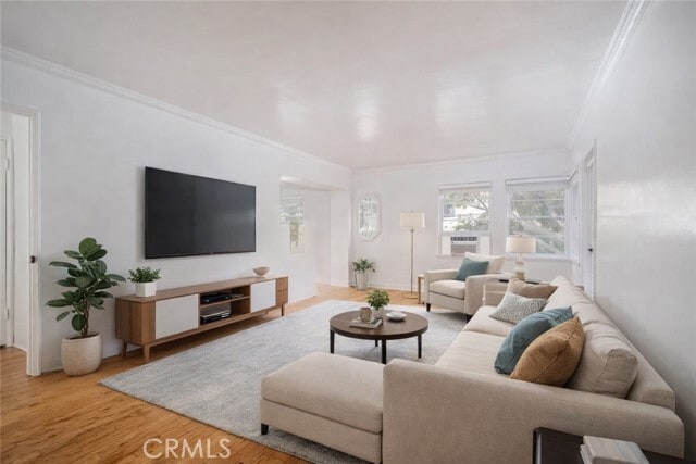
Highlights
- Wood Flooring
- Stone Countertops
- Neighborhood Views
- Balcony
- Wood Frame Window
- Eat-In Kitchen
265 N Swall Dr

Favorites
About This Home
12 Month Lease,
$3,300 deposit,
Available Now
Nestled in a charming tree-lined neighborhood in the heart of Beverly Hills, this freshly painted, oversized top-floor corner unit seamlessly blends original character with modern touches. It boasts charming hardwood floors, original moldings, a spacious living room, a full dining room, a kitchen, and a spacious private balcony perfect for enjoying your mornings. Recently upgraded with a new bathroom, this unit is conveniently situated between Doheny and Robertson, just a stone's throw away from Rodeo Drive, Wilshire, and all the trendy restaurants. Call today and book your private tour. MLS# SR25281539
265 N Swall Dr is an apartment community located in Los Angeles County and the 90211 ZIP Code.
* Price shown is base rent. Excludes user-selected optional fees and variable or usage-based fees and required charges due at or prior to move-in or at move-out. Price, availability, fees, and any applicable rent special are subject to change without notice.
* Square footage definitions vary. Displayed square footage is approximate.
Home Details
Year Built
Built in 1938
Bedrooms and Bathrooms
Walk-in Shower
1 Main Level Bedroom
1 Full Bathroom
Home Design
Turnkey
Apartment
Entry on the 1st floor
Interior Spaces
Wood Flooring
Wood Frame Window
Combination Dining and Living Room
900 Sq Ft Home
2-Story Property
Kitchen
Stone Countertops
Eat-In Kitchen
Laundry
Laundry Room
Listing and Financial Details
Security Deposit $3,300
12-Month Minimum Lease Term
Available 1/6/25
Tax Lot 138
Tax Tract Number 7005
Assessor Parcel Number 4335021001
Rent includes water
Lot Details
5,724 Sq Ft Lot
Rectangular Lot
Two or More Common Walls
Property is zoned BHR4YY
Outdoor Features
Balcony
Patio
Exterior Lighting
Parking
Detached Carport Space
Parking Available
1 Car Garage
Utilities
Cooling System Mounted To A Wall/Window
Wall Furnace
Natural Gas Connected
Views
Neighborhood Views
Community Details
Amenities
Laundry Facilities
Overview
6 Units
No Home Owners Association
Fees and Policies
The fees listed below are community-provided and may exclude utilities or add-ons. All payments are made directly to the property and are non-refundable unless otherwise specified. Use the Cost Calculator to determine costs based on your needs.
-
One-Time Basics
-
Due at Move-In
-
Security Deposit - RefundableCharged per unit.$3,300
-
-
Due at Move-In
-
Covered
Property Fee Disclaimer: Based on community-supplied data and independent market research. Subject to change without notice. May exclude fees for mandatory or optional services and usage-based utilities.
Details
Utilities Included
-
Water
Lease Options
-
12 Months
Contact
- Listed by Brandon Melgar | Luxury Collective
- Phone Number
- Contact
-
Source
 California Regional Multiple Listing Service
Copyright 2026 © California Regional MLS. All rights reserved.
Location
Get Directions
Beverly Hills, spanning just 5.71 square miles, combines elegant residential areas with world-class shopping and dining. Tree-lined streets and well-maintained green spaces like Beverly Gardens Park along Santa Monica Boulevard create an inviting atmosphere. The Golden Triangle shopping district, home to the renowned Rodeo Drive, offers high-end retail experiences. Housing options range from estates in Trousdale Estates to apartments south of Wilshire Boulevard, where one-bedroom apartments currently average $2,728 with a 1.1% increase year-over-year.
The city celebrates arts and culture through venues like the Wallis Annenberg Center for the Performing Arts and the historic Greystone Mansion. Landmarks such as the Beverly Hills Hotel and Beverly Wilshire Hotel contribute to the area's distinctive character. Notable areas include the residential streets north of Santa Monica Boulevard and the South Beverly Drive district, with its local shops and eateries.
Learn more about living in Beverly Hills
Amenities
- Air Conditioning
- Heating
- Hardwood Floors
- Laundry Facilities
- Balcony
- Patio
Expenses
Utilities Included
Water
Included
Education
| Colleges & Universities | Distance | ||
|---|---|---|---|
| Colleges & Universities | Distance | ||
| Drive: | 10 min | 4.5 mi | |
| Drive: | 10 min | 4.9 mi | |
| Drive: | 10 min | 5.2 mi | |
| Drive: | 14 min | 5.5 mi |
265 N Swall Dr is within 10 minutes or 4.5 miles from UCLA. It is also near Musicians Institute and Los Angeles Film School.
Transportation options available in Beverly Hills include Culver City, located 3.3 miles from 265 N Swall Dr. 265 N Swall Dr is near Los Angeles International, located 11.1 miles or 22 minutes away, and Bob Hope, located 13.2 miles or 25 minutes away.
| Transit / Subway | Distance | ||
|---|---|---|---|
| Transit / Subway | Distance | ||
|
|
Drive: | 8 min | 3.3 mi |
|
|
Drive: | 9 min | 3.8 mi |
|
|
Drive: | 8 min | 4.0 mi |
|
|
Drive: | 10 min | 4.2 mi |
|
|
Drive: | 9 min | 4.8 mi |
| Commuter Rail | Distance | ||
|---|---|---|---|
| Commuter Rail | Distance | ||
|
|
Drive: | 18 min | 9.5 mi |
|
|
Drive: | 21 min | 9.7 mi |
|
|
Drive: | 20 min | 10.8 mi |
|
|
Drive: | 22 min | 11.1 mi |
|
|
Drive: | 24 min | 12.1 mi |
| Airports | Distance | ||
|---|---|---|---|
| Airports | Distance | ||
|
Los Angeles International
|
Drive: | 22 min | 11.1 mi |
|
Bob Hope
|
Drive: | 25 min | 13.2 mi |
Time and distance from 265 N Swall Dr.
| Shopping Centers | Distance | ||
|---|---|---|---|
| Shopping Centers | Distance | ||
| Walk: | 15 min | 0.8 mi | |
| Walk: | 16 min | 0.8 mi | |
| Walk: | 16 min | 0.9 mi |
265 N Swall Dr has 3 shopping centers within 0.9 mile, which is about a 16-minute walk. The miles and minutes will be for the farthest away property.
| Parks and Recreation | Distance | ||
|---|---|---|---|
| Parks and Recreation | Distance | ||
|
Zimmer Children's Museum
|
Drive: | 3 min | 1.4 mi |
|
La Brea Tar Pits
|
Drive: | 4 min | 2.1 mi |
|
Virginia Robinson Gardens
|
Drive: | 7 min | 2.8 mi |
|
Mathias Botanical Garden
|
Drive: | 9 min | 4.0 mi |
|
Runyon Canyon
|
Drive: | 10 min | 4.3 mi |
265 N Swall Dr has 5 parks within 4.3 miles, including Zimmer Children's Museum, La Brea Tar Pits, and Virginia Robinson Gardens.
| Hospitals | Distance | ||
|---|---|---|---|
| Hospitals | Distance | ||
| Walk: | 12 min | 0.6 mi | |
| Drive: | 3 min | 1.8 mi | |
| Drive: | 4 min | 2.0 mi |
265 N Swall Dr has 3 hospitals within 2.0 miles, the nearest is Cedars-Sinai Medical Center which is 0.6 mile away and a 12 minute walk.
| Military Bases | Distance | ||
|---|---|---|---|
| Military Bases | Distance | ||
| Drive: | 21 min | 12.7 mi |
265 N Swall Dr is 12.7 miles and a 21 minute drive from Los Angeles Air Force Base.
You May Also Like
Similar Rentals Nearby
-
-
-
-
-
-
-
-
1 Bed$2,851+2 Beds$3,468+Total Monthly PriceTotal Monthly Price NewPrices include base rent and required monthly fees of $15. Variable costs based on usage may apply.Base Rent:1 Bed$2,836+2 Beds$3,453+Specials
Pets Allowed In Unit Washer & Dryer Maintenance on site Heat Controlled Access Elevator
-
-


What Are Walk Score®, Transit Score®, and Bike Score® Ratings?
Walk Score® measures the walkability of any address. Transit Score® measures access to public transit. Bike Score® measures the bikeability of any address.
What is a Sound Score Rating?
A Sound Score Rating aggregates noise caused by vehicle traffic, airplane traffic and local sources

265 N Swall Dr
Beverly Hills, CA 90211