

$4,400
Total Monthly Price
262 Shawmut Ave
Boston, MA 02118
Favorites
-
Bedrooms
3
-
Bathrooms
1
-
Square Feet
950 sq ft
262 Shawmut Ave

Favorites
About This Home
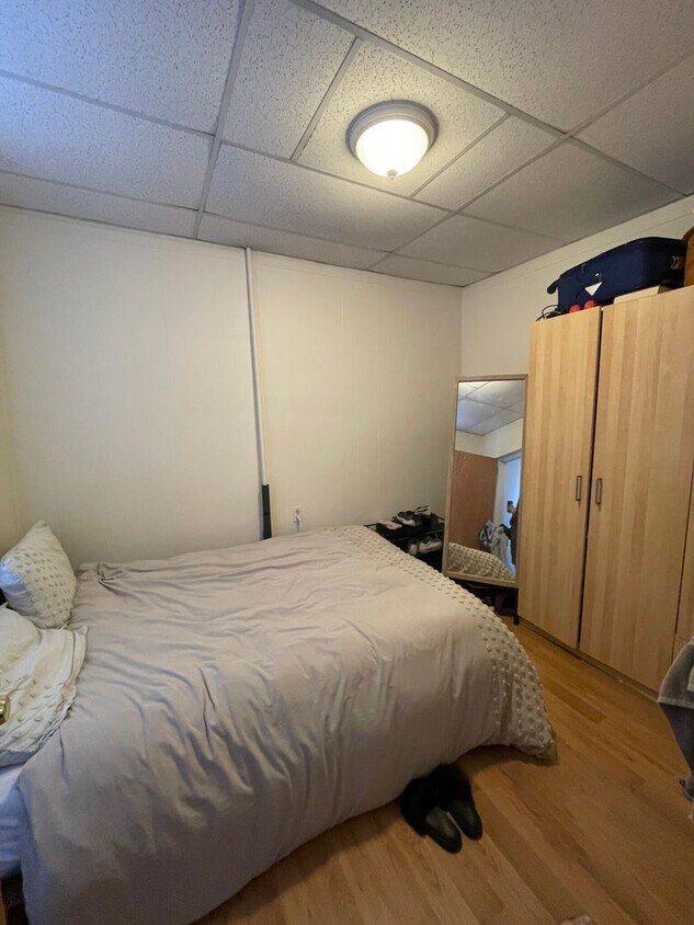
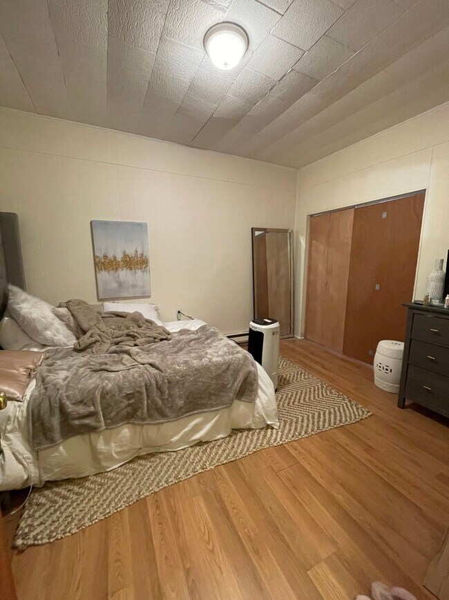
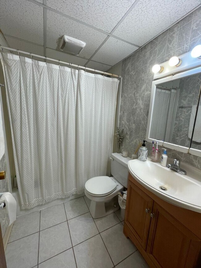
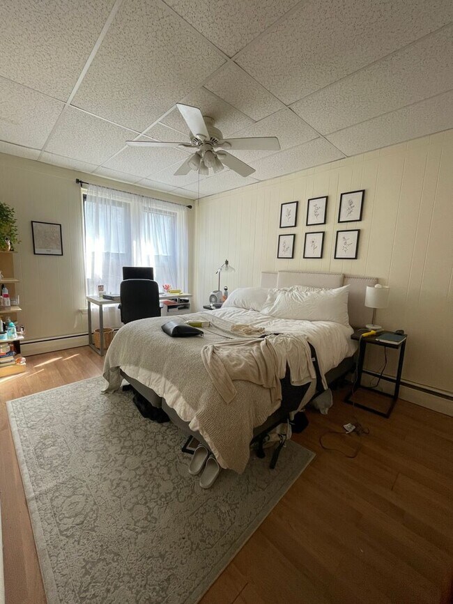
Available September 1 Spacious 3 Bedroom with no Living Room or 2 Bed with office) Large living room overlooking Shawmut Ave Eat in the Kitchen with a Gas Stove Hardwood Floors Throughout Heat & Hot Water Included in the rent PROPERTY INFO ID: 361044669 Rent: $4,400 / Month Beds: 3 Bath: 1 Available Date: 09/01/2025 Pet: No Pets Rent Includes:: Heat, Hot Water FEATURES Ceramic Tiles Eat-in Kitchen Hardwood Floors Pantry Separate Kitchen
262 Shawmut Ave is a condo located in Suffolk County and the 02118 ZIP Code. This area is served by the Boston Public Schools attendance zone.
* Price shown is total price based on community-supplied monthly required fees. Excludes user-selected optional fees and variable or usage-based fees and required charges due at or prior to move-in or at move-out. Price, availability, fees, and any applicable rent special are subject to change without notice.
* Square footage definitions vary. Displayed square footage is approximate.
Contact
- Listed by Modern Real Estate (AD) | Modern Real Estate (AD)
Location
Get Directions
There's much to love about Boston's South End -- the elegant brownstones along Tremont Street, the fantastic shops and restaurants of Columbus Avenue, and the sophisticated yet collegiate feel of Harrison Avenue combine to create a tapestry of a neighborhood that offers something to everyone. This walkable, tree-filled neighborhood offers several parks, the Boston University School of Medicine, some of the best restaurants in the city, and easy access to Northeastern University.
By renting an apartment in South End Boston, you'll enjoy walking along brick-paved sidewalks past historic buildings housing everything from trendy boutiques to art galleries to the city's hottest cafes. You'll spend afternoons shopping at Copley Square and taking in sprawling greenery at Southwest Corridor Park, Blackstone Square, and beautiful Franklin Square. South End is popular with artists, and you'll discover a variety of terrific galleries to explore, especially along Harrison Avenue.
Learn more about living in South End Boston
Education
| Colleges & Universities | Distance | ||
|---|---|---|---|
| Colleges & Universities | Distance | ||
| Walk: | 12 min | 0.7 mi | |
| Walk: | 15 min | 0.8 mi | |
| Drive: | 4 min | 1.2 mi | |
| Drive: | 4 min | 1.3 mi |
262 Shawmut Ave is within 12 minutes or 0.7 mile from Tufts University, Boston. It is also near Emerson College and Berklee College of Music.
Schools


Public Elementary, Middle & High School
Grades K-12
80 Students
Attendance Zone
Public Elementary School
Grades PK-5
572 Students
Attendance Zone
Public Middle & High School
Grades 6-12
50 Students
Attendance Zone
Public Middle & High School
Grades 6-12
575 Students
Attendance Zone
Public High School
Grades 9-12
435 Students
Attendance Zone
Private Elementary School
Grades PK-5
142 Students
Nearby
Private Middle & High School
Grades 6-12
292 Students
Nearby
School data provided by
 The GreatSchools Rating helps parents compare schools within a state based on a variety of school quality indicators and provides a helpful picture of how effectively each school serves all of its students. Ratings are on a scale of 1 (below average) to 10 (above average) and can include test scores, college readiness, academic progress, advanced courses, equity, discipline and attendance data. We also advise parents to visit schools, consider other information on school performance and programs, and consider family needs as part of the school selection process.
View GreatSchools Rating Methodology
Data provided by GreatSchools.org © 2026. All rights reserved.
View GreatSchools Rating Methodology
Data provided by GreatSchools.org © 2026. All rights reserved.
Transportation options available in Boston include New England Medical Center Station, located 0.6 mile from 262 Shawmut Ave. 262 Shawmut Ave is near General Edward Lawrence Logan International, located 5.0 miles or 11 minutes away.
| Transit / Subway | Distance | ||
|---|---|---|---|
| Transit / Subway | Distance | ||
|
|
Walk: | 11 min | 0.6 mi |
|
|
Walk: | 13 min | 0.7 mi |
|
|
Walk: | 13 min | 0.7 mi |
|
|
Drive: | 4 min | 1.2 mi |
|
|
Drive: | 4 min | 1.2 mi |
| Commuter Rail | Distance | ||
|---|---|---|---|
| Commuter Rail | Distance | ||
|
|
Walk: | 12 min | 0.6 mi |
|
|
Drive: | 4 min | 1.5 mi |
| Drive: | 4 min | 1.9 mi | |
|
|
Drive: | 5 min | 2.1 mi |
|
|
Drive: | 7 min | 2.2 mi |
| Airports | Distance | ||
|---|---|---|---|
| Airports | Distance | ||
|
General Edward Lawrence Logan International
|
Drive: | 11 min | 5.0 mi |
Getting Around
 What do Walkability, Transit, Drivability, and Bikeability mean?
Walkability measures the walking distance to day-to-day needs.
Transit measures access to public transportation.
Drivability measures congestion, parking availability, and access to major roads.
Bikeability measures the suitability for cycling.
How It Works
What do Walkability, Transit, Drivability, and Bikeability mean?
Walkability measures the walking distance to day-to-day needs.
Transit measures access to public transportation.
Drivability measures congestion, parking availability, and access to major roads.
Bikeability measures the suitability for cycling.
How It Works
Exceptionally Walkable
Walkability
100
/ 100
Exceptional Public Transit
Transit
100
/ 100
Somewhat Drivable
Drivability
30
/ 100
Very Bikeable
Bikeability
80
/ 100
Scores provided by
-
Soundscore™
-
/ 100
Traffic
-Airport
-Businesses
-Scores provided by
HowLoud What is a Sound Score Rating? A Sound Score Rating aggregates noise caused by vehicle traffic, airplane traffic and local sources. How It WorksTime and distance from 262 Shawmut Ave.
| Shopping Centers | Distance | ||
|---|---|---|---|
| Shopping Centers | Distance | ||
| Drive: | 6 min | 1.8 mi | |
| Drive: | 9 min | 5.6 mi | |
| Drive: | 10 min | 5.8 mi |
262 Shawmut Ave has 3 shopping centers within 5.8 miles, which is about a 10-minute drive. The miles and minutes will be for the farthest away property.
| Parks and Recreation | Distance | ||
|---|---|---|---|
| Parks and Recreation | Distance | ||
|
Boston Public Garden
|
Walk: | 17 min | 0.9 mi |
|
Boston African American National Historic Site
|
Drive: | 4 min | 1.4 mi |
|
Boston National Historical Park
|
Drive: | 5 min | 1.7 mi |
|
Boston Harbor Islands National Recreation Area
|
Drive: | 5 min | 1.7 mi |
|
Boston Children's Museum
|
Drive: | 5 min | 1.8 mi |
262 Shawmut Ave has 5 parks within 1.8 miles, including Boston Public Garden, Boston African American National Historic Site, and Boston National Historical Park.
| Hospitals | Distance | ||
|---|---|---|---|
| Hospitals | Distance | ||
| Walk: | 10 min | 0.6 mi | |
| Walk: | 12 min | 0.7 mi | |
| Drive: | 3 min | 1.4 mi |
262 Shawmut Ave has 3 hospitals within 1.4 miles, the nearest is Tufts Medical Center which is 0.6 mile away and a 10 minute walk.
| Military Bases | Distance | ||
|---|---|---|---|
| Military Bases | Distance | ||
| Drive: | 30 min | 16.5 mi | |
| Drive: | 31 min | 18.6 mi | |
| Drive: | 36 min | 21.2 mi |
262 Shawmut Ave has 3 military bases within 21.2 miles, the nearest is Hanscom Air Force Base which is 16.5 miles away and a 30 minute drive.
You May Also Like
Similar Rentals Nearby


What Are Walk Score®, Transit Score®, and Bike Score® Ratings?
Walk Score® measures the walkability of any address. Transit Score® measures access to public transit. Bike Score® measures the bikeability of any address.
What is a Sound Score Rating?
A Sound Score Rating aggregates noise caused by vehicle traffic, airplane traffic and local sources.

262 Shawmut Ave
Boston, MA 02118