

$850
/ Month
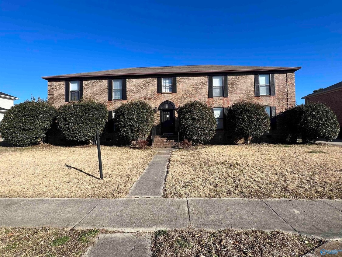
2602 Wynterhall Rd SE Unit A
Huntsville, AL 35803
Today
|
Edit
Favorites
256-631-6382
-
Bedrooms
2
-
Bathrooms
2
-
Square Feet
--
-
Available
Available Mar 29
Highlights
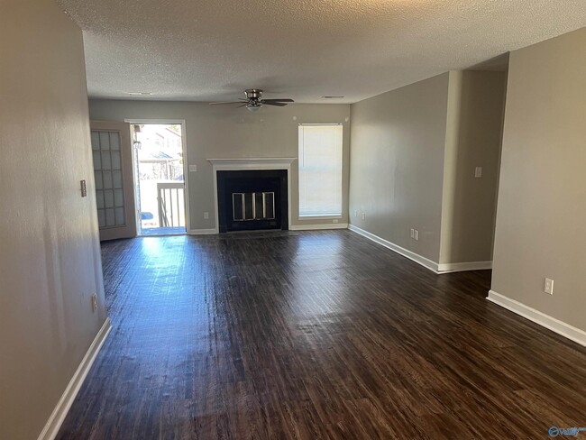
- 1 Fireplace
- Living Room
- Central Heating and Cooling System
2602 Wynterhall Rd SE Unit A

Favorites
About This Home
Available Mar 29
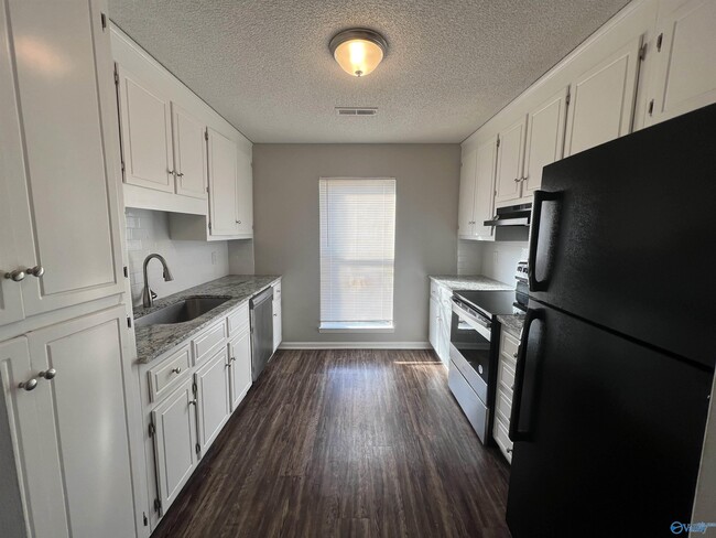
Welcome home to this updated 2 bed 2 bath apartment. This home offers stainless steel appliances,lots of space/storage,and laundry hookups. Pets allowed. Schedule your tour before it's gone!
2602 Wynterhall Rd Se is an apartment community located in Madison County and the 35803 ZIP Code.
* Price shown is base rent. Excludes user-selected optional fees and variable or usage-based fees and required charges due at or prior to move-in or at move-out. Price, availability, fees, and any applicable rent special are subject to change without notice.
* Square footage definitions vary. Displayed square footage is approximate.
Home Details
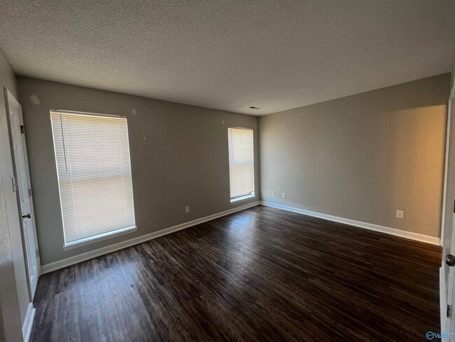
Bedrooms and Bathrooms
2 Full Bathrooms
2 Bedrooms
Home Design
Apartment
Interior Spaces
1 Fireplace
Living Room
1,250 Sq Ft Home
Property has 1 Level
Listing and Financial Details
12-Month Minimum Lease Term
Legal Lot and Block 3 / D
Lot Details
13,939 Sq Ft Lot
Parking
No Garage
Schools
Challenger Elementary School
Grissom High School
Utilities
Central Heating and Cooling System
Community Details
Overview
Gourdneck Subdivision
Contact
- Listed by Elizabeth Hall | Puliatti Properties
- Phone Number
- Contact
-
Source
 ValleyMLS
Valleymls.com is the official website of the North Alabama Multiple Listing Service, Inc. (ValleyMLS.Com) and includes the participation of seven REALTOR® associations. Valleymls.com includes active properties and new homes listed by 2300+ REALTORS® for more than 13,000 properties in North Alabama
Location
Get Directions
The Huntsville neighborhood of Farley-Oakhurst Place is a vast, diverse area just south of Downtown Huntsville. Situated along the banks of the Tennessee River, bounded to the north by Mountain Gap Road, and to the east by Shawdee Road, Farley-Oakhurst encompasses both suburban residential developments and untouched countryside. The neighborhood, especially the northern section, has become popular with families and renters looking to stay to close to the action of Huntsville while enjoying a more affordable space of their own. Memorial Parkway Southwest (Highway 231) is where you’ll find both locally owned restaurants and national chains ranging from pizza and wings to sandwiches and Italian food.
Most of the rentals in this part of the city can be found closer to Downtown Huntsville. Low-rise apartments with plenty of amenities and new single-family home developments round the rental market.
Learn more about living in Farley-Oakhurst Place
Amenities
- Air Conditioning
Education
| Colleges & Universities | Distance | ||
|---|---|---|---|
| Colleges & Universities | Distance | ||
| Drive: | 20 min | 11.6 mi | |
| Drive: | 22 min | 11.7 mi | |
| Drive: | 24 min | 13.8 mi | |
| Drive: | 25 min | 14.0 mi |
2602 Wynterhall Rd SE Unit A is within 20 minutes or 11.6 miles from Univ. of Ala. Huntsville. It is also near Calhoun C.C., Huntsville and Alabama A&M University.
Getting Around
 What do Walkability, Transit, Drivability, and Bikeability mean?
Walkability measures the walking distance to day-to-day needs.
Transit measures access to public transportation.
Drivability measures congestion, parking availability, and access to major roads.
Bikeability measures the suitability for cycling.
How It Works
What do Walkability, Transit, Drivability, and Bikeability mean?
Walkability measures the walking distance to day-to-day needs.
Transit measures access to public transportation.
Drivability measures congestion, parking availability, and access to major roads.
Bikeability measures the suitability for cycling.
How It Works
Somewhat Walkable
Walkability
30
/ 100
Very Drivable
Drivability
80
/ 100
Fairly Bikeable
Bikeability
50
/ 100
Scores provided by
Calm
Soundscore™
84
/ 100
Traffic
CalmAirport
CalmBusinesses
CalmScores provided by
HowLoud What is a Sound Score Rating? A Sound Score Rating aggregates noise caused by vehicle traffic, airplane traffic and local sources. How It WorksYou May Also Like
Similar Rentals Nearby


What Are Walk Score®, Transit Score®, and Bike Score® Ratings?
Walk Score® measures the walkability of any address. Transit Score® measures access to public transit. Bike Score® measures the bikeability of any address.
What is a Sound Score Rating?
A Sound Score Rating aggregates noise caused by vehicle traffic, airplane traffic and local sources.
2602 Wynterhall Rd SE
Huntsville, AL 35803