
26 Humphrey St
Englewood, NJ 07631
-
Bedrooms
1
-
Bathrooms
1
-
Square Feet
--
-
Available
Available Nov 1
Highlight
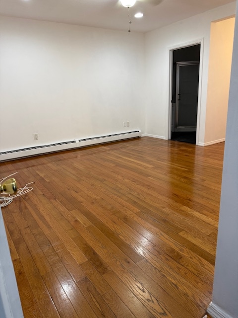
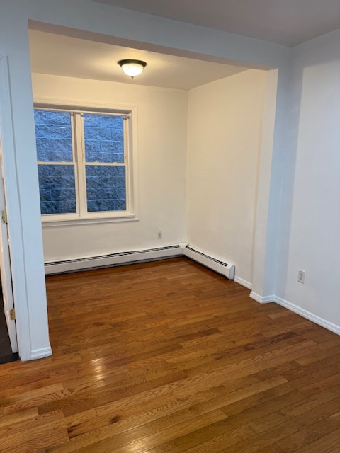
- Hardwood Floors

About This Home
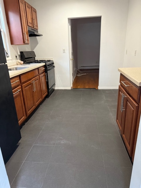
Property Id: 2174471 (1) Bedroom with closet, (1) Bathroom, kitchen with space for small table, living room area, additional area for office or dining, entry space with rack, additional storage closet.
26 Humphrey St is a house located in Bergen County and the 07631 ZIP Code. This area is served by the Englewood Public attendance zone.
House Features
Hardwood Floors
Refrigerator
Freezer
Oven
- Oven
- Refrigerator
- Freezer
- Hardwood Floors
Fees and Policies
The fees below are based on community-supplied data and may exclude additional fees and utilities.
Details
Utilities Included
-
Water
Contact
- Phone Number
- Contact
-
Source

- Oven
- Refrigerator
- Freezer
- Hardwood Floors
Englewood is a suburban city where residents enjoy peaceful, tree-lined streets only 20 miles northeast of Manhattan. Accessible to the big city by car or public transit, Englewood residents enjoy an easy commute. The majority of Englewood is comprised of residential avenues holding a variety of rental options. East Palisade Avenue is the heart of the community; restaurants representing all corners of the world, chain eateries, convenience stores, boutiques, music venues, and so much more line this bustling road. To enjoy the outdoors, residents have options of intown parks like Flat Rock Brook Nature Center, or they can travel a bit outside of town to the parks and trails along the Hudson River.
Learn more about living in Englewood| Colleges & Universities | Distance | ||
|---|---|---|---|
| Colleges & Universities | Distance | ||
| Drive: | 9 min | 4.6 mi | |
| Drive: | 9 min | 4.9 mi | |
| Drive: | 11 min | 6.0 mi | |
| Drive: | 18 min | 9.9 mi |


View GreatSchools Rating Methodology
Data provided by GreatSchools.org © 2025. All rights reserved.
Transportation options available in Englewood include 181 Street (A Line), located 5.4 miles from 26 Humphrey St. 26 Humphrey St is near LaGuardia, located 14.9 miles or 27 minutes away, and Newark Liberty International, located 19.0 miles or 24 minutes away.
| Transit / Subway | Distance | ||
|---|---|---|---|
| Transit / Subway | Distance | ||
|
|
Drive: | 9 min | 5.4 mi |
|
|
Drive: | 12 min | 6.0 mi |
|
|
Drive: | 12 min | 6.6 mi |
|
|
Drive: | 12 min | 6.7 mi |
|
|
Drive: | 12 min | 7.0 mi |
| Commuter Rail | Distance | ||
|---|---|---|---|
| Commuter Rail | Distance | ||
|
|
Drive: | 7 min | 4.2 mi |
|
|
Drive: | 10 min | 4.6 mi |
|
|
Drive: | 17 min | 8.4 mi |
|
|
Drive: | 17 min | 9.1 mi |
|
|
Drive: | 19 min | 10.5 mi |
| Airports | Distance | ||
|---|---|---|---|
| Airports | Distance | ||
|
LaGuardia
|
Drive: | 27 min | 14.9 mi |
|
Newark Liberty International
|
Drive: | 24 min | 19.0 mi |
Time and distance from 26 Humphrey St.
| Shopping Centers | Distance | ||
|---|---|---|---|
| Shopping Centers | Distance | ||
| Walk: | 4 min | 0.2 mi | |
| Walk: | 5 min | 0.3 mi | |
| Walk: | 7 min | 0.4 mi |
| Parks and Recreation | Distance | ||
|---|---|---|---|
| Parks and Recreation | Distance | ||
|
Flat Rock Brook Nature Center
|
Drive: | 6 min | 2.0 mi |
|
Teaneck Creek Conservancy
|
Drive: | 7 min | 3.3 mi |
|
Overpeck County Park
|
Drive: | 8 min | 3.6 mi |
|
Tenafly Nature Center
|
Drive: | 8 min | 4.5 mi |
|
Inwood Hill Park
|
Drive: | 13 min | 7.6 mi |
| Hospitals | Distance | ||
|---|---|---|---|
| Hospitals | Distance | ||
| Walk: | 18 min | 1.0 mi | |
| Drive: | 5 min | 2.7 mi | |
| Drive: | 12 min | 6.3 mi |
| Military Bases | Distance | ||
|---|---|---|---|
| Military Bases | Distance | ||
| Drive: | 28 min | 16.4 mi |
26 Humphrey St Photos
Nearby Apartments
Within 50 Miles of 26 Humphrey St Englewood, NJ 07631
-
23 Stein Ave
Wallington, NJ 07057
$3,500
3 Br 7.2 mi
-
529 54th St
West New York, NJ 07093
$2,195
2 Br 7.8 mi
-
5500 Park Ave
West New York, NJ 07093
$3,200
3 Br 7.9 mi
-
351 Piermont Ave
Piermont, NY 10968
$4,995
3 Br 10.4 mi
-
10 Bridge St
Tarrytown, NY 10591
$1,550
1 Br 13.6 mi
-
499 Highland Ave
Orange, NJ 07050
$3,900
5 Br 16.5 mi
What Are Walk Score®, Transit Score®, and Bike Score® Ratings?
Walk Score® measures the walkability of any address. Transit Score® measures access to public transit. Bike Score® measures the bikeability of any address.
What is a Sound Score Rating?
A Sound Score Rating aggregates noise caused by vehicle traffic, airplane traffic and local sources
26 Humphrey St
Englewood, NJ 07631