$1,900
/ Month
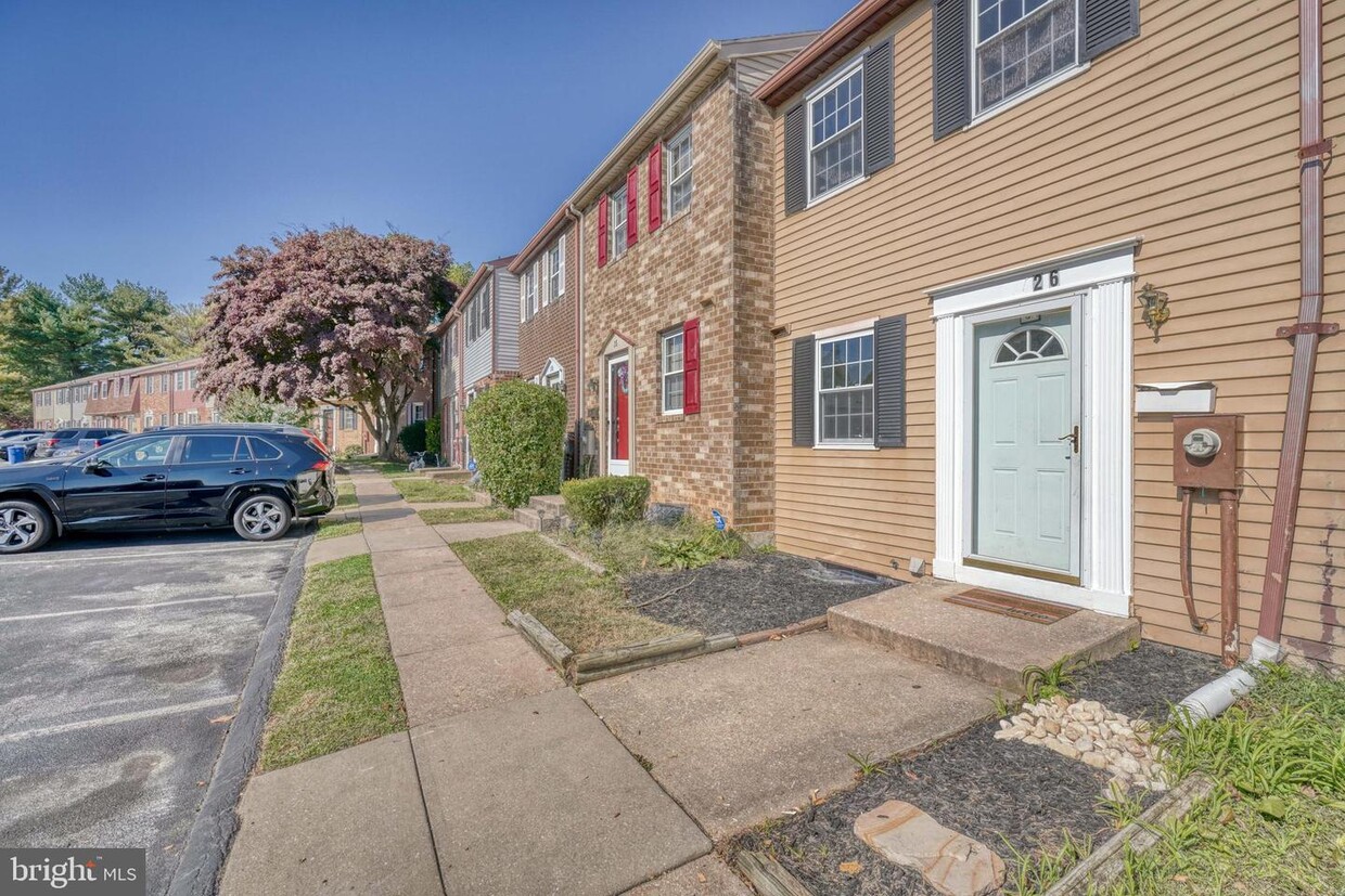
26 Garrison Ridge Ct
Owings Mills, MD 21117
2 Weeks Ago
|
Edit
Favorites
26 Garrison Ridge Ct

Favorites
Check Back Soon for Upcoming Availability
| Beds | Baths | Average SF |
|---|---|---|
| 2 Bedrooms 2 Bedrooms 2 Br | 1 Bath 1 Bath 1 Ba | — |
About This Property
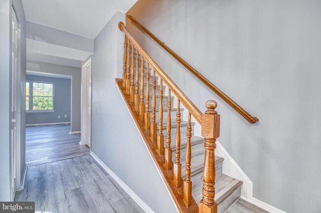
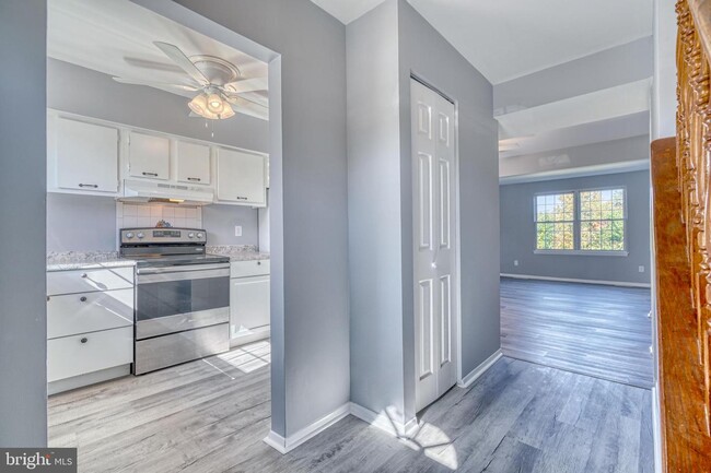
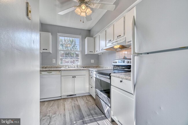
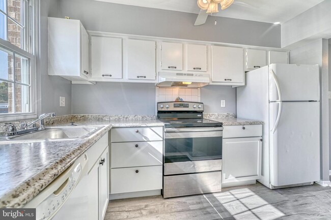
Welcome to this well maintained 2 bedroom/ 2 bath, TH located in Owings Mills. It has new flooring throughout as well as some minor updates. The main level has a welcoming foyer, living/ dining room combo, and a kitchen with a food pantry. The upper level has two sizable bedrooms, and the master bedroom has his and her closets. The lower level has a full bath with shower. There is an additional room in the basement that can be used as a home office, a workout room, playroom, or bedroom, the possibilities are endless! Move in as early as November 1st.
26 Garrison Ridge Ct is a townhome located in Baltimore County and the 21117 ZIP Code. This area is served by the Baltimore County Public Schools attendance zone.
Townhome Features
- Basement
Location
Get Directions
Located in Baltimore County, Owings Mills combines suburban living with easy city access. This community northwest of Baltimore features natural attractions like Soldiers Delight Natural Environment Area, known for its rare serpentinite ecosystem. Residents enjoy convenient transportation via the Baltimore Metro Subway and shopping at Mill Station and Foundry Row, home to Wegmans and Costco. One-bedroom apartments in Owings Mills rent for $1,579 monthly, while two-bedroom units average $1,897, reflecting a 2.5% year-over-year increase.
The area is home to McDonogh School and Stevenson University, while major employers include T. Rowe Price, CareFirst, and the Baltimore Ravens' headquarters. Maryland Public Television studios adds to the community's media presence. With approximately 35,700 residents, Owings Mills offers various housing options from apartment communities to established neighborhoods, all within easy reach of Baltimore's attractions.
Learn more about living in Owings Mills
Amenities
- Basement
Education
| Colleges & Universities | Distance | ||
|---|---|---|---|
| Colleges & Universities | Distance | ||
| Drive: | 5 min | 1.7 mi | |
| Drive: | 16 min | 6.3 mi | |
| Drive: | 25 min | 13.3 mi | |
| Drive: | 29 min | 14.3 mi |
26 Garrison Ridge Ct is within 5 minutes or 1.7 miles from Stevenson Univ., Owings Mills. It is also near Stevenson Univ., Greenspring and Notre Dame of Md. Univ..
Schools


Public Elementary School
Grades PK-5
745 Students
Attendance Zone
Public Middle School
Grades 6-8
1,322 Students
Attendance Zone
Public High School
Grades 9-12
1,199 Students
Attendance Zone
Private Elementary, Middle & High School
Grades 2-12
167 Students
Nearby
Private Elementary & Middle School
Grades PK-8
95 Students
Nearby
School data provided by
 The GreatSchools Rating helps parents compare schools within a state based on a variety of school quality indicators and provides a helpful picture of how effectively each school serves all of its students. Ratings are on a scale of 1 (below average) to 10 (above average) and can include test scores, college readiness, academic progress, advanced courses, equity, discipline and attendance data. We also advise parents to visit schools, consider other information on school performance and programs, and consider family needs as part of the school selection process.
View GreatSchools Rating Methodology
Data provided by GreatSchools.org © 2026. All rights reserved.
View GreatSchools Rating Methodology
Data provided by GreatSchools.org © 2026. All rights reserved.
Transportation options available in Owings Mills include Old Court, located 5.5 miles from 26 Garrison Ridge Ct. 26 Garrison Ridge Ct is near Baltimore/Washington International Thurgood Marshall, located 20.5 miles or 33 minutes away.
| Transit / Subway | Distance | ||
|---|---|---|---|
| Transit / Subway | Distance | ||
| Drive: | 13 min | 5.5 mi | |
| Drive: | 16 min | 6.2 mi | |
| Drive: | 19 min | 7.5 mi | |
| Drive: | 15 min | 8.1 mi | |
| Drive: | 21 min | 8.2 mi |
| Commuter Rail | Distance | ||
|---|---|---|---|
| Commuter Rail | Distance | ||
| Drive: | 25 min | 15.9 mi | |
|
|
Drive: | 25 min | 16.0 mi |
|
|
Drive: | 29 min | 16.2 mi |
|
|
Drive: | 29 min | 16.7 mi |
|
|
Drive: | 33 min | 20.2 mi |
| Airports | Distance | ||
|---|---|---|---|
| Airports | Distance | ||
|
Baltimore/Washington International Thurgood Marshall
|
Drive: | 33 min | 20.5 mi |
Time and distance from 26 Garrison Ridge Ct.
| Shopping Centers | Distance | ||
|---|---|---|---|
| Shopping Centers | Distance | ||
| Walk: | 14 min | 0.8 mi | |
| Walk: | 17 min | 0.9 mi | |
| Walk: | 18 min | 1.0 mi |
26 Garrison Ridge Ct has 3 shopping centers within 1.0 mile, which is about a 18-minute walk. The miles and minutes will be for the farthest away property.
| Parks and Recreation | Distance | ||
|---|---|---|---|
| Parks and Recreation | Distance | ||
|
Irvine Nature Center
|
Drive: | 8 min | 2.7 mi |
|
Soldiers Delight Natural Environment Area (NEA)
|
Drive: | 11 min | 5.1 mi |
|
Rodgers Farms
|
Drive: | 13 min | 5.6 mi |
|
Patapsco Valley State Park
|
Drive: | 25 min | 10.2 mi |
|
Oregon Ridge Park
|
Drive: | 25 min | 11.2 mi |
26 Garrison Ridge Ct has 5 parks within 11.2 miles, including Irvine Nature Center, Soldiers Delight Natural Environment Area (NEA), and Rodgers Farms.
| Hospitals | Distance | ||
|---|---|---|---|
| Hospitals | Distance | ||
| Drive: | 11 min | 5.6 mi | |
| Drive: | 22 min | 9.2 mi | |
| Drive: | 22 min | 9.2 mi |
26 Garrison Ridge Ct has 3 hospitals within 9.2 miles, the nearest is Northwest Hospital Center which is 5.6 miles away and a 11 minute drive.
| Military Bases | Distance | ||
|---|---|---|---|
| Military Bases | Distance | ||
| Drive: | 47 min | 28.4 mi |
26 Garrison Ridge Ct is 28.4 miles and a 47 minute drive from Fort George Meade.
You May Also Like
Similar Rentals Nearby


What Are Walk Score®, Transit Score®, and Bike Score® Ratings?
Walk Score® measures the walkability of any address. Transit Score® measures access to public transit. Bike Score® measures the bikeability of any address.
What is a Sound Score Rating?
A Sound Score Rating aggregates noise caused by vehicle traffic, airplane traffic and local sources

26 Garrison Ridge Ct
Owings Mills, MD 21117