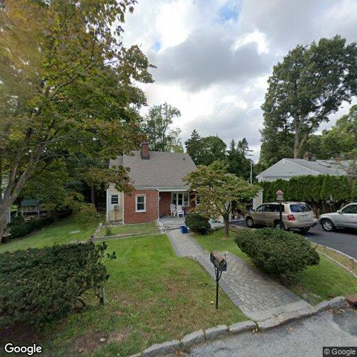

26 Chestnut St
26 Chestnut St
Ardsley, NY 10502
2 Weeks Ago
Favorites
26 Chestnut St

Favorites
Check Back Soon for Upcoming Availability
Location
Get Directions
Nestled in southern Westchester County, Ardsley is a tranquil village lush with natural beauty. Spanning just 1.3 square miles, Ardsley is a largely residential community brimming with small-town charm and an overall peaceful atmosphere. Ardsley naturally offers a wide variety of apartments, condos, and houses available for rent along tree-dense boulevards.
Ardsley’s scenic environment also provides ample opportunities for outdoor recreation. McDowell Park, VE Macy Park, and Ridge Road Park are among the many popular venues for enjoying the outdoors nearby. Although Ardsley is mostly residential, the community relishes access to an array of restaurants and shops strewn along Saw Mill River Road, the village’s main commercial thoroughfare. Getting around from Ardsley is simple with convenience to I-87 and Sprain Brook Parkway.
Learn more about living in Ardsley
Education
| Colleges & Universities | Distance | ||
|---|---|---|---|
| Colleges & Universities | Distance | ||
| Drive: | 9 min | 3.5 mi | |
| Drive: | 10 min | 5.1 mi | |
| Drive: | 11 min | 5.5 mi | |
| Drive: | 11 min | 5.8 mi |
26 Chestnut St is within 9 minutes or 3.5 miles from Mercy College. It is also near SUNY Westchester and New York Medical College.
Transportation options available in Ardsley include Wakefield-241 Street, located 11.0 miles from 26 Chestnut St. 26 Chestnut St is near Westchester County, located 12.9 miles or 20 minutes away, and LaGuardia, located 23.2 miles or 36 minutes away.
| Transit / Subway | Distance | ||
|---|---|---|---|
| Transit / Subway | Distance | ||
|
|
Drive: | 16 min | 11.0 mi |
|
|
Drive: | 17 min | 11.4 mi |
|
|
Drive: | 18 min | 12.0 mi |
|
|
Drive: | 20 min | 12.3 mi |
|
|
Drive: | 18 min | 12.4 mi |
| Commuter Rail | Distance | ||
|---|---|---|---|
| Commuter Rail | Distance | ||
|
|
Drive: | 8 min | 3.5 mi |
|
|
Drive: | 9 min | 3.9 mi |
|
|
Drive: | 10 min | 4.3 mi |
|
|
Drive: | 11 min | 4.4 mi |
|
|
Drive: | 11 min | 5.0 mi |
| Airports | Distance | ||
|---|---|---|---|
| Airports | Distance | ||
|
Westchester County
|
Drive: | 20 min | 12.9 mi |
|
LaGuardia
|
Drive: | 36 min | 23.2 mi |
Time and distance from 26 Chestnut St.
| Shopping Centers | Distance | ||
|---|---|---|---|
| Shopping Centers | Distance | ||
| Walk: | 16 min | 0.9 mi | |
| Drive: | 3 min | 1.4 mi | |
| Drive: | 3 min | 1.4 mi |
26 Chestnut St has 3 shopping centers within 1.4 miles, which is about a 3-minute walk. The miles and minutes will be for the farthest away property.
| Parks and Recreation | Distance | ||
|---|---|---|---|
| Parks and Recreation | Distance | ||
|
Old Croton Aqueduct State Historic Park
|
Drive: | 7 min | 3.2 mi |
|
Greenburgh Nature Center
|
Drive: | 11 min | 5.0 mi |
|
Lenoir Preserve
|
Drive: | 10 min | 6.1 mi |
|
Stone Barns Center for Food and Agriculture
|
Drive: | 13 min | 7.2 mi |
|
Tallman Mountain State Park
|
Drive: | 22 min | 14.0 mi |
26 Chestnut St has 5 parks within 14.0 miles, including Old Croton Aqueduct State Historic Park, Greenburgh Nature Center, and Lenoir Preserve.
| Hospitals | Distance | ||
|---|---|---|---|
| Hospitals | Distance | ||
| Drive: | 9 min | 6.0 mi | |
| Drive: | 9 min | 6.1 mi | |
| Drive: | 9 min | 6.2 mi |
26 Chestnut St has 3 hospitals within 6.2 miles, the nearest is Blythedale Children's Hospital which is 6.0 miles away and a 9 minute drive.
| Military Bases | Distance | ||
|---|---|---|---|
| Military Bases | Distance | ||
| Drive: | 36 min | 22.2 mi | |
| Drive: | 39 min | 25.4 mi |
26 Chestnut St is 22.2 miles from Fort Totten US Govt Reservation, and is convenient to other military bases, including Camp Smith NY State Military.
You May Also Like
Similar Rentals Nearby


What Are Walk Score®, Transit Score®, and Bike Score® Ratings?
Walk Score® measures the walkability of any address. Transit Score® measures access to public transit. Bike Score® measures the bikeability of any address.
What is a Sound Score Rating?
A Sound Score Rating aggregates noise caused by vehicle traffic, airplane traffic and local sources