

$1,595 / Month
2565 Franklin Ave Unit 406
Saint Paul, MN 55114
2 Weeks Ago
Favorites
2565 Franklin Ave Unit 406

Favorites
Check Back Soon for Upcoming Availability
| Beds | Baths | Average SF |
|---|---|---|
| 1 Bedroom 1 Bedroom 1 Br | 2 Baths 2 Baths 2 Ba | 1,041 SF |
Fees and Policies
The fees below are based on community-supplied data and may exclude additional fees and utilities.
- Dogs Allowed
-
Fees not specified
- Cats Allowed
-
Fees not specified
- Parking
-
Garage--
Details
Utilities Included
-
Water
-
Trash Removal
Property Information
-
Furnished Units Available
About This Property
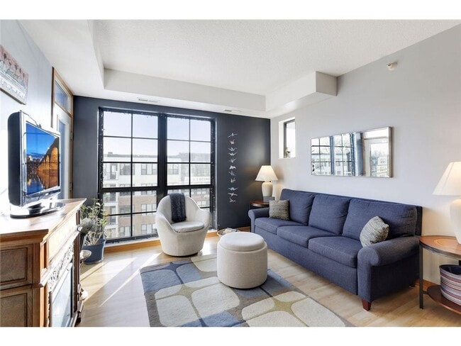
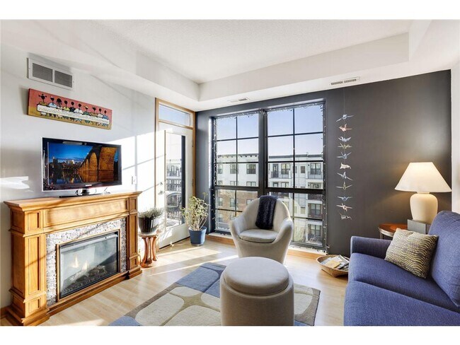
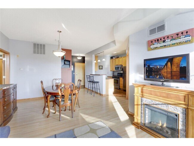
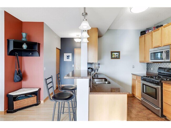
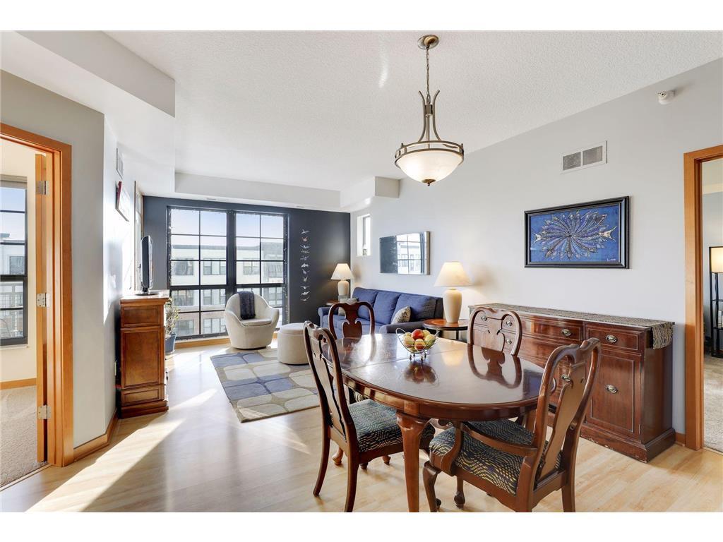
Newly Furnished 1 plus den, 1.5BA with parking stall, and fast access to highways and light rail, all nestled in St Anthony Park. Live on a quiet residential street, but steps from the Witch’s Hat Tower in Prospect Park, the light rail station on University Ave, I94 & Hwy 280. Inside you’ll find the bedrooms and bathrooms on opposite sides of the unit; modern and functional furnishings; honeycomb blinds; tons of closet space; and an upgraded kitchen with a large peninsula, stone countertops, stainless steel appliances, and gas oven. Included with rent: basic cable & internet, water/sewer/trash, and indoor heated parking stall near the elevator along with outside parking with permit.
2565 Franklin Ave is a condo located in Ramsey County and the 55114 ZIP Code. This area is served by the St. Paul Public attendance zone.
Condo Features
- Smoke Free
- Furnished
- Laundry Facilities
Location
Get Directions
Situated in the northwestern corner of Saint Paul, Saint Anthony Park is a charming neighborhood between the downtowns of Saint Paul and Minneapolis. Saint Anthony Park’s small business district exudes the feel of an urban village, with plenty of quaint shops and local restaurants in Tudor-style buildings stretched along Como Avenue.
Outside of the business district, Saint Anthony Park is predominantly residential. The neighborhood is teeming with apartments and single-family homes covered in lush trees and landscaping. Langford Park offers residents numerous opportunities for outdoor recreation while the sprawling Como Regional Park lies just outside the neighborhood’s boundaries.
Saint Anthony Park is convenient to an array of notable amenities, including the University of Minnesota’s Saint Paul Campus, the Minnesota State Fair, and Rosedale Center. Convenience to I-94 and multiple light rail stations makes getting around from Saint Anthony Park simple.
Learn more about living in St AnthonyBelow are rent ranges for similar nearby apartments
| Beds | Average Size | Lowest | Typical | Premium |
|---|---|---|---|---|
| Studio Studio Studio | 464 Sq Ft | $1,102 | $1,367 | $3,331 |
| 1 Bed 1 Bed 1 Bed | 691-692 Sq Ft | $909 | $1,592 | $3,610 |
| 2 Beds 2 Beds 2 Beds | 1063-1066 Sq Ft | $805 | $2,010 | $5,788 |
| 3 Beds 3 Beds 3 Beds | 1359 Sq Ft | $1,895 | $2,266 | $3,289 |
| 4 Beds 4 Beds 4 Beds | 1854 Sq Ft | $515 | $1,526 | $3,000 |
Amenities
- Smoke Free
- Furnished
- Laundry Facilities
Expenses
Utilities Included
Water, Trash Removal
Included
Education
| Colleges & Universities | Distance | ||
|---|---|---|---|
| Colleges & Universities | Distance | ||
| Drive: | 6 min | 2.0 mi | |
| Drive: | 7 min | 2.3 mi | |
| Drive: | 8 min | 2.6 mi | |
| Drive: | 6 min | 2.7 mi |
2565 Franklin Ave Unit 406 is within 6 minutes or 2.7 miles from Augsburg College. It is also near University of Minnesota and Univ. of St Thomas, St. Paul.
Schools


Public Elementary School
Grades PK-5
202 Students
Nearby
Public Elementary School
Grades K-6
505 Students
Attendance Zone
Public Middle School
Grades 6-8
538 Students
Attendance Zone
Public High School
Grades 9-12
1,078 Students
Attendance Zone
Private Elementary, Middle & High School
Grades PK-12
965 Students
Nearby
School data provided by
 The GreatSchools Rating helps parents compare schools within a state based on a variety of school quality indicators and provides a helpful picture of how effectively each school serves all of its students. Ratings are on a scale of 1 (below average) to 10 (above average) and can include test scores, college readiness, academic progress, advanced courses, equity, discipline and attendance data. We also advise parents to visit schools, consider other information on school performance and programs, and consider family needs as part of the school selection process.
View GreatSchools Rating Methodology
Data provided by GreatSchools.org © 2025. All rights reserved.
View GreatSchools Rating Methodology
Data provided by GreatSchools.org © 2025. All rights reserved.
Transportation options available in Saint Paul include Westgate Station, located 0.3 mile from 2565 Franklin Ave Unit 406. 2565 Franklin Ave Unit 406 is near Minneapolis-St Paul International/Wold-Chamberlain, located 9.7 miles or 20 minutes away.
| Transit / Subway | Distance | ||
|---|---|---|---|
| Transit / Subway | Distance | ||
| Walk: | 5 min | 0.3 mi | |
| Walk: | 11 min | 0.6 mi | |
| Walk: | 14 min | 0.7 mi | |
| Drive: | 4 min | 1.3 mi | |
| Drive: | 5 min | 1.6 mi |
| Commuter Rail | Distance | ||
|---|---|---|---|
| Commuter Rail | Distance | ||
| Drive: | 12 min | 5.3 mi | |
|
|
Drive: | 11 min | 6.9 mi |
| Drive: | 19 min | 13.2 mi | |
| Drive: | 29 min | 22.2 mi | |
| Drive: | 31 min | 23.8 mi |
| Airports | Distance | ||
|---|---|---|---|
| Airports | Distance | ||
|
Minneapolis-St Paul International/Wold-Chamberlain
|
Drive: | 20 min | 9.7 mi |
Time and distance from 2565 Franklin Ave Unit 406.
| Shopping Centers | Distance | ||
|---|---|---|---|
| Shopping Centers | Distance | ||
| Drive: | 5 min | 1.4 mi | |
| Drive: | 4 min | 1.6 mi | |
| Drive: | 6 min | 2.0 mi |
2565 Franklin Ave Unit 406 has 3 shopping centers within 2.0 miles, which is about a 6-minute drive. The miles and minutes will be for the farthest away property.
| Parks and Recreation | Distance | ||
|---|---|---|---|
| Parks and Recreation | Distance | ||
|
Tower Hill Park
|
Walk: | 11 min | 0.6 mi |
|
Luxton Park
|
Walk: | 15 min | 0.8 mi |
|
Matthews Park
|
Drive: | 5 min | 1.5 mi |
|
East River Flats Park
|
Drive: | 7 min | 1.8 mi |
|
Brackett Park
|
Drive: | 7 min | 2.2 mi |
2565 Franklin Ave Unit 406 has 5 parks within 2.2 miles, including Tower Hill Park, Luxton Park, and East River Flats Park.
| Hospitals | Distance | ||
|---|---|---|---|
| Hospitals | Distance | ||
| Drive: | 5 min | 2.6 mi | |
| Drive: | 9 min | 3.3 mi | |
| Drive: | 7 min | 4.0 mi |
2565 Franklin Ave Unit 406 has 3 hospitals within 4.0 miles, the nearest is University of Minnesota Medical Center, Fairview which is 2.6 miles away and a 5 minute drive.
| Military Bases | Distance | ||
|---|---|---|---|
| Military Bases | Distance | ||
| Drive: | 18 min | 7.4 mi |
2565 Franklin Ave Unit 406 is 7.4 miles and a 18 minute drive from Fort Snelling Military Reservation.
You May Also Like
Similar Rentals Nearby


What Are Walk Score®, Transit Score®, and Bike Score® Ratings?
Walk Score® measures the walkability of any address. Transit Score® measures access to public transit. Bike Score® measures the bikeability of any address.
What is a Sound Score Rating?
A Sound Score Rating aggregates noise caused by vehicle traffic, airplane traffic and local sources
2565 Franklin Ave
Saint Paul, MN 55114