
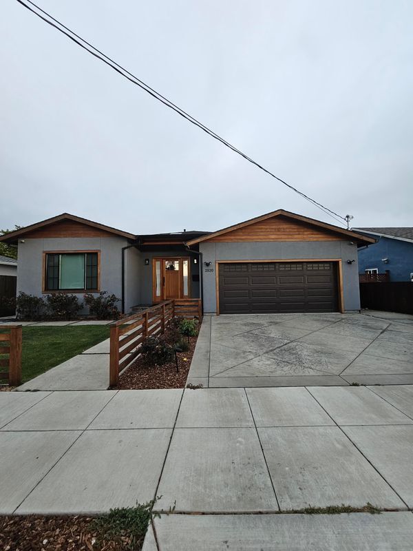
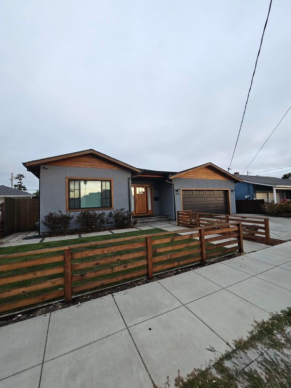
2520 Garvin Ave
Richmond, CA 94804
-
Bedrooms
4
-
Bathrooms
2.5
-
Square Feet
1,853 sq ft
-
Available
Available Now

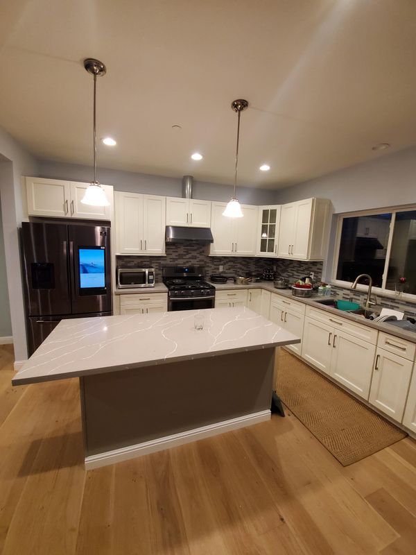
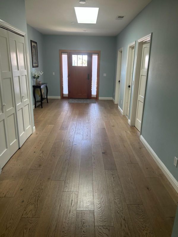
About This Home
Welcome to your next home in Richmond, CA, located in the vibrant North & East district. This inviting property features a comfortable living space ideal for anyone looking to settle in a community that balances urban convenience with suburban charm. Enjoy easy access to essential amenities with Kaiser Permanente Richmond Medical Center just 6 minutes away, and excellent educational options like Aspire Richmond California College Preparatory Academy and St. David of Wales School within a short drive. Plus, the nearby Nicholl Park and Burg Park offer lovely outdoor spaces for relaxation and recreation. This rental does not include utilities, which allows you the flexibility to choose services that best meet your needs. Don't miss out on this opportunity to make this property your new home! Contact us today to schedule a viewing and experience the community for yourself. Your ideal living space awaits. Call me, I am Grace, your Agent pro at .
2520 Garvin Ave is a house located in Contra Costa County and the 94804 ZIP Code. This area is served by the West Contra Costa Unified attendance zone.
House Features
- Renters Insurance Program
Fees and Policies
The fees below are based on community-supplied data and may exclude additional fees and utilities.
- Parking
-
Other--Assigned Parking
Details
Lease Options
-
12 Months
Contact
- Phone Number
- Website View Property Website
- Contact
-
Source

- Renters Insurance Program
With reasonable rents and a great deal of community spirit, the North and East neighborhood of Richmond proves itself ideal for residents who want to be active in community groups and who thrive on a little bit of urban grit. Community involvement runs strong here in this neighborhood that sits only 10 to 15 minutes away from the quirky scene in Berkeley.
When you want a break from city life, Wildcat Canyon Regional Park sits less than a mile from the east edge of North and East. Bring your mountain bike or just hike through the 2,400-acre park centered on Wildcat Creek. When you have to get back to work, AC Transit, BART, and the transbay buses can get you to Oakland, 11 miles away, or even across the Bay to San Francisco and places beyond.
Learn more about living in North & East| Colleges & Universities | Distance | ||
|---|---|---|---|
| Colleges & Universities | Distance | ||
| Drive: | 5 min | 2.5 mi | |
| Drive: | 15 min | 8.7 mi | |
| Drive: | 19 min | 9.7 mi | |
| Drive: | 21 min | 13.0 mi |


View GreatSchools Rating Methodology
Data provided by GreatSchools.org © 2025. All rights reserved.
Transportation options available in Richmond include Richmond Station, located 0.9 mile from 2520 Garvin Ave. 2520 Garvin Ave is near Metro Oakland International, located 21.7 miles or 30 minutes away, and San Francisco International, located 29.3 miles or 43 minutes away.
| Transit / Subway | Distance | ||
|---|---|---|---|
| Transit / Subway | Distance | ||
|
|
Walk: | 17 min | 0.9 mi |
|
|
Drive: | 5 min | 2.4 mi |
|
|
Drive: | 5 min | 2.4 mi |
|
|
Drive: | 8 min | 4.4 mi |
|
|
Drive: | 14 min | 8.1 mi |
| Commuter Rail | Distance | ||
|---|---|---|---|
| Commuter Rail | Distance | ||
| Drive: | 2 min | 1.1 mi | |
|
|
Drive: | 11 min | 7.3 mi |
|
|
Drive: | 13 min | 9.1 mi |
| Drive: | 19 min | 11.2 mi | |
| Drive: | 19 min | 12.2 mi |
| Airports | Distance | ||
|---|---|---|---|
| Airports | Distance | ||
|
Metro Oakland International
|
Drive: | 30 min | 21.7 mi |
|
San Francisco International
|
Drive: | 43 min | 29.3 mi |
Time and distance from 2520 Garvin Ave.
| Shopping Centers | Distance | ||
|---|---|---|---|
| Shopping Centers | Distance | ||
| Walk: | 17 min | 0.9 mi | |
| Drive: | 3 min | 1.2 mi | |
| Drive: | 2 min | 1.3 mi |
| Parks and Recreation | Distance | ||
|---|---|---|---|
| Parks and Recreation | Distance | ||
|
Marina Park & Green
|
Drive: | 5 min | 2.4 mi |
|
Rosie the Riveter WWII Home Front National Historical Park
|
Drive: | 6 min | 2.9 mi |
|
Shimada Friendship Park
|
Drive: | 6 min | 2.9 mi |
|
Miller/Knox Regional Shoreline
|
Drive: | 8 min | 3.9 mi |
|
Point Isabel Regional Shoreline
|
Drive: | 11 min | 5.1 mi |
| Hospitals | Distance | ||
|---|---|---|---|
| Hospitals | Distance | ||
| Drive: | 18 min | 10.3 mi | |
| Drive: | 16 min | 11.2 mi | |
| Drive: | 15 min | 11.2 mi |
| Military Bases | Distance | ||
|---|---|---|---|
| Military Bases | Distance | ||
| Drive: | 5 min | 2.4 mi | |
| Drive: | 11 min | 5.1 mi | |
| Drive: | 24 min | 15.4 mi |
2520 Garvin Ave Photos
Nearby Apartments
Within 50 Miles of 2520 Garvin Ave Richmond, CA 94804
-
680 Hiller Dr
Oakland, CA 94618
$7,900 - $9,750
5 Br 8.9 mi
-
Admirals Cove
250 Mosley Ave
Alameda, CA 94501
$4,798 - $4,923
4 Br 11.2 mi
-
1647 Dewey St
Vallejo, CA 94590
$3,045
4 Br 13.2 mi
-
1236 Utah St
San Francisco, CA 94110
$1,200
7 Br 13.5 mi
-
361 Inverness Dr
Vallejo, CA 94589
$2,695
4 Br 13.8 mi
-
4020 Edwards Ave
Oakland, CA 94605
$3,941
5 Br 15.2 mi
What Are Walk Score®, Transit Score®, and Bike Score® Ratings?
Walk Score® measures the walkability of any address. Transit Score® measures access to public transit. Bike Score® measures the bikeability of any address.
What is a Sound Score Rating?
A Sound Score Rating aggregates noise caused by vehicle traffic, airplane traffic and local sources

2520 Garvin Ave
Richmond, CA 94804