
$8,900
/ Month
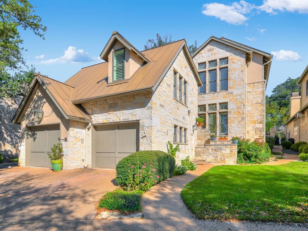
2510 W 35th St
Austin, TX 78703
Today
|
Edit
Favorites
512-917-3439
-
Bedrooms
4
-
Bathrooms
5
-
Square Feet
3,435 sq ft
-
Available
Available Now
Highlights
- Open Floorplan
- Wood Flooring
- Main Floor Primary Bedroom
- High Ceiling
- Multiple Living Areas
- 2 Car Attached Garage
2510 W 35th St

Favorites
About This Home
Available Now
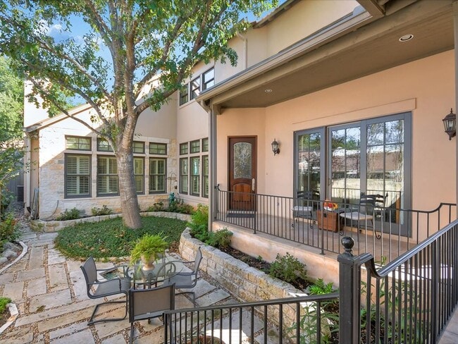
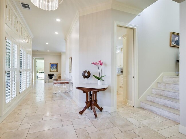
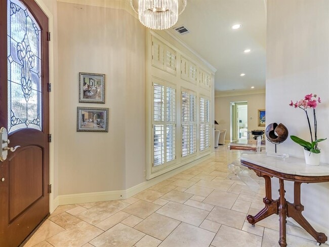
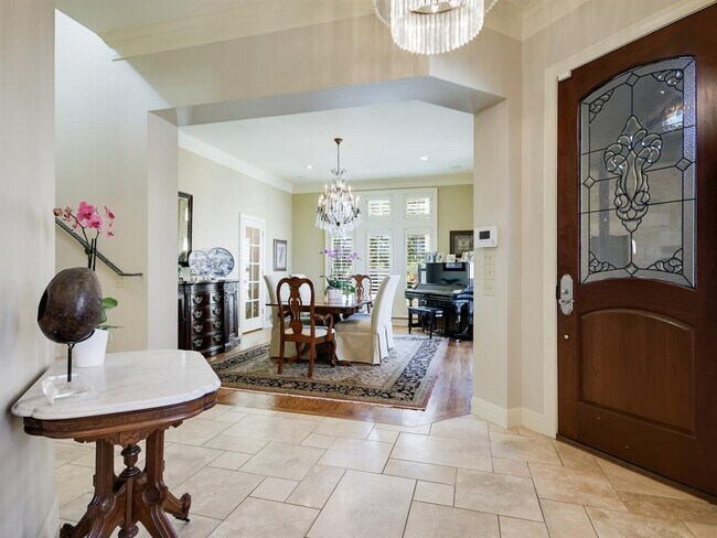
This well cared for home has an open floorplan includes formal dining room, large family room, breakfast room, guest bath, the primary bedroom and bath all downstairs. there are 2 additional bedrooms upstairs each with ensuite baths and an additional living area. Located above the garage is a guest apartment and a bathroom. This can be used for a home office or perfect for guests. 2 car garage.This home is available furnished or unfurnished. MLS ID 5277995
2510 W 35Th St is a house located in Travis County and the 78703 ZIP Code. This area is served by the Austin Independent attendance zone.
* Price shown is base rent. Excludes user-selected optional fees and variable or usage-based fees and required charges due at or prior to move-in or at move-out. Price, availability, fees, and any applicable rent special are subject to change without notice.
* Square footage definitions vary. Displayed square footage is approximate.
Home Details
Home Type
Single Family Detached Home
Year Built
Built in 1999
Bedrooms and Bathrooms
4 Bedrooms | 1 Primary Bedroom on Main
Soaking Tub
Double Vanity
Walk-In Closet
4.5 Bathrooms
Flooring
Wood
Stone
Carpet
Home Design
Slab Foundation
Interior Spaces
Open Floorplan
Living Room with Fireplace
High Ceiling
Multiple Living Areas
Built-In Features
Storage
Ceiling Fan
Dining Area
Furnished or left unfurnished upon request
3,435 Sq Ft Home
2-Story Property
Kitchen
Built-In Oven
Breakfast Bar
Kitchen Island
Cooktop
Microwave
Disposal
Listing and Financial Details
Security Deposit $10,000
Negotiable Lease Term
$50 Application Fee
Assessor Parcel Number 01210402300000
Tax Block A
The owner pays for association fees
Lot Details
9,514 Sq Ft Lot
South Facing Home
Parking
2 Car Attached Garage
Schools
Casis Elementary School
O Henry Middle School
Austin High School
Utilities
Central Air
Natural Gas Connected
Community Details
Overview
Property has a Home Owners Association
Perlitz Subdivision
Pet Policy
Pets allowed on a case-by-case basis
Pet Deposit $1,000
Contact
- Listed by Tammy Koen | Compass RE Texas, LLc
- Phone Number
- Contact
-
Source
 Austin Board of REALTORS®
The information included in this listing is provided exclusively for consumers’ personal, non-commercial use and may not be used for any purpose other than to identify prospective properties consumers may be interested in purchasing. The information on each listing is furnished by the owner and deemed reliable to the best of his/her knowledge, but should be verified by the purchaser. ABoR, ACTRIS and Estately assume no responsibility for typographical errors, misprints or misinformation. This property listing is offered without respect to any protected classes in accordance with the law. Copyright © 2026.
Location
Get Directions
Amenities
- Disposal
- Microwave
- Refrigerator
- Hardwood Floors
- Carpet
Highland Park West is located along the Colorado River, directly north of Tarrytown and four miles northwest of Downtown Austin. This sought-after location is hilly and wooded with attractive homes atop manicured lawns. Nearby parks take full advantage of the river’s natural beauty, such as the panoramic river views from Covert Park at Mount Bonnell. Bright Leaf Preserve offers scheduled tours through the 200-acre park, culminating in stunning hilltop views.
Camp Mabry, a military installation, occupies the southern part of Highland Park West and is home to the Texas Military Forces Museum. Perry Neighborhood Park is in the center of the neighborhood, near the top-rated Highland Park Elementary School. While most shops and restaurants are located outside of Highland Park West, there is a small shopping area along Hancock Drive that includes a Pampered Pets and a Balcones Books. Russell’s Bakery & Coffee Bar, a popular neighborhood destination, is also located here.
Learn more about living in Highland Park West
Education
| Colleges & Universities | Distance | ||
|---|---|---|---|
| Colleges & Universities | Distance | ||
| Drive: | 5 min | 3.3 mi | |
| Drive: | 8 min | 4.0 mi | |
| Drive: | 12 min | 6.6 mi | |
| Drive: | 13 min | 8.2 mi |
2510 W 35th St is within 8 minutes or 4.0 miles from University of Texas at Austin. It is also near Austin C.C., Rio Grande Campus and Austin C.C., Eastview Campus.
Schools


Public Elementary School
Grades PK-5
599 Students
Attendance Zone
Public Middle School
Grades 6-8
754 Students
Attendance Zone
Public High School
Grades 9-12
2,317 Students
Attendance Zone
Private Elementary & Middle School
Grades PK-8
114 Students
Nearby
Private Elementary School
Grades K-5
Nearby
Private Elementary, Middle & High School
Grades 1-12
207 Students
Nearby
School data provided by
 The GreatSchools Rating helps parents compare schools within a state based on a variety of school quality indicators and provides a helpful picture of how effectively each school serves all of its students. Ratings are on a scale of 1 (below average) to 10 (above average) and can include test scores, college readiness, academic progress, advanced courses, equity, discipline and attendance data. We also advise parents to visit schools, consider other information on school performance and programs, and consider family needs as part of the school selection process.
View GreatSchools Rating Methodology
Data provided by GreatSchools.org © 2026. All rights reserved.
View GreatSchools Rating Methodology
Data provided by GreatSchools.org © 2026. All rights reserved.
Transportation options available in Austin include Highland Station, located 3.9 miles from 2510 W 35th St. 2510 W 35th St is near Austin-Bergstrom International, located 15.4 miles or 29 minutes away.
| Transit / Subway | Distance | ||
|---|---|---|---|
| Transit / Subway | Distance | ||
| Drive: | 9 min | 3.9 mi | |
| Drive: | 10 min | 4.2 mi | |
| Drive: | 8 min | 4.7 mi | |
| Drive: | 9 min | 5.3 mi | |
| Drive: | 10 min | 5.8 mi |
| Commuter Rail | Distance | ||
|---|---|---|---|
| Commuter Rail | Distance | ||
|
|
Drive: | 7 min | 3.8 mi |
|
|
Drive: | 43 min | 35.0 mi |
|
|
Drive: | 44 min | 35.4 mi |
| Airports | Distance | ||
|---|---|---|---|
| Airports | Distance | ||
|
Austin-Bergstrom International
|
Drive: | 29 min | 15.4 mi |
Time and distance from 2510 W 35th St.
| Shopping Centers | Distance | ||
|---|---|---|---|
| Shopping Centers | Distance | ||
| Walk: | 10 min | 0.5 mi | |
| Walk: | 14 min | 0.8 mi | |
| Walk: | 15 min | 0.8 mi |
2510 W 35th St has 3 shopping centers within 0.8 mile, which is about a 15-minute walk. The miles and minutes will be for the farthest away property.
| Parks and Recreation | Distance | ||
|---|---|---|---|
| Parks and Recreation | Distance | ||
|
Mayfield Park and Preserve
|
Walk: | 15 min | 0.8 mi |
|
Shoal Creek Greenbelt Park
|
Drive: | 5 min | 2.2 mi |
|
Elisabet Ney Museum
|
Drive: | 6 min | 2.8 mi |
|
Bright Leaf Preserve
|
Drive: | 7 min | 3.8 mi |
|
Red Bud Isle
|
Drive: | 8 min | 4.2 mi |
2510 W 35th St has 5 parks within 4.2 miles, including Mayfield Park and Preserve, Shoal Creek Greenbelt Park, and Elisabet Ney Museum.
| Hospitals | Distance | ||
|---|---|---|---|
| Hospitals | Distance | ||
| Walk: | 16 min | 0.9 mi | |
| Walk: | 20 min | 1.0 mi | |
| Drive: | 4 min | 2.0 mi |
2510 W 35th St has 3 hospitals within 2.0 miles, the nearest is Seton Shoal Creek Hospital which is 0.9 mile away and a 16 minute walk.
| Military Bases | Distance | ||
|---|---|---|---|
| Military Bases | Distance | ||
| Drive: | 86 min | 70.4 mi | |
| Drive: | 90 min | 72.6 mi |
2510 W 35th St is 70.4 miles from Randolph Air Force Base, and is convenient to other military bases, including Fort Hood.
You May Also Like
Similar Rentals Nearby
-
-

-
-
-
1 / 23

-
-
-

-

-


What Are Walk Score®, Transit Score®, and Bike Score® Ratings?
Walk Score® measures the walkability of any address. Transit Score® measures access to public transit. Bike Score® measures the bikeability of any address.
What is a Sound Score Rating?
A Sound Score Rating aggregates noise caused by vehicle traffic, airplane traffic and local sources

2510 W 35th St
Austin, TX 78703