

$1,415
/ Month
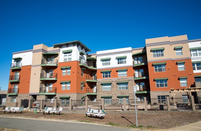
25 Harbour Way Unit #25
Richmond, CA 94801
Favorites
-
Bedrooms
2
-
Bathrooms
1
-
Square Feet
--
25 Harbour Way Unit #25

Favorites
About This Home
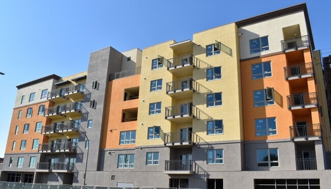
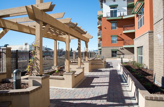
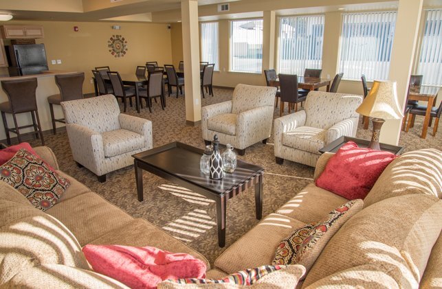
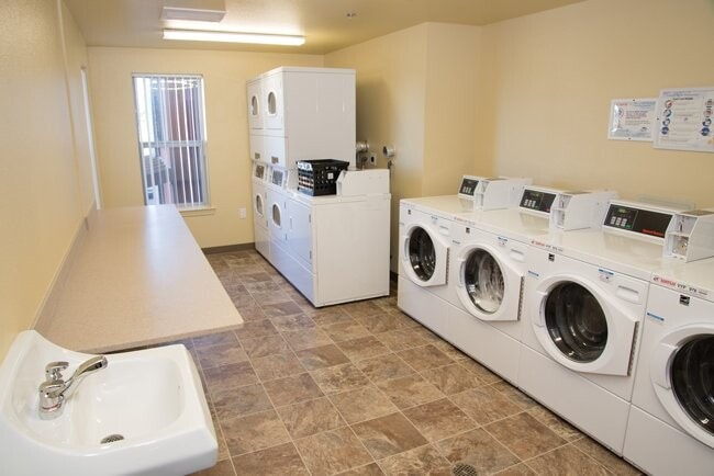
Welcome to Harbour View Senior with one and two bedroom apartments! Located near shopping, a pharmacy, a park with a walking trail and a bus stop, our beautiful property has wonderful amenities including a community room with a kitchen, a craft room, an exercise room and a secured entrance and elevator for your convenience. Your apartment will include energy efficient appliances, a patio or balcony and much more.
25 Harbour Way is a condo located in Contra Costa County and the 94801 ZIP Code.
* Price shown is base rent. Excludes user-selected optional fees and variable or usage-based fees and required charges due at or prior to move-in or at move-out. Price, availability, fees, and any applicable rent special are subject to change without notice.
* Square footage definitions vary. Displayed square footage is approximate.
Contact
- Listed by Leasing Agent | Leasing Agent
Location
Get Directions
The Iron Triangle neighborhood sits in the heart of Central Richmond, California. With the area being largely residential, most rentals reside in the upper part of the triangle and an easy three-mile commute north to Point Richmond, a major shipping and industrial area. To the south, Berkeley and Oakland lie roughly 10 miles away via Interstate 580.
Locals often head for the Miller/Knox Regional Shoreline for a bit of jogging or cycling, or to cast a line off the fishing pier. Wade into the waters of San Francisco Bay at Keller Beach on the northern end of the park, or enjoy a show at the Masquers Playhouse, also just outside the Iron Triangle's southern border. Most eateries sit along Interstate 580, including several fast food chains. The MacDonald 80 Shopping Center lies roughly three miles east of the neighborhood. Drive another three miles and find Wildcat Canyon Regional Park and the Tilden Nature Area.
Learn more about living in Iron Triangle
Education
| Colleges & Universities | Distance | ||
|---|---|---|---|
| Colleges & Universities | Distance | ||
| Drive: | 8 min | 3.6 mi | |
| Drive: | 15 min | 8.8 mi | |
| Drive: | 19 min | 9.8 mi | |
| Drive: | 18 min | 11.4 mi |
25 Harbour Way Unit #25 is within 8 minutes or 3.6 miles from Contra Costa College. It is also near Berkeley City College and UC Berkeley.
Transportation options available in Richmond include Richmond Station, located 1.1 miles from 25 Harbour Way Unit #25. 25 Harbour Way Unit #25 is near Metro Oakland International, located 21.8 miles or 30 minutes away, and San Francisco International, located 29.4 miles or 42 minutes away.
| Transit / Subway | Distance | ||
|---|---|---|---|
| Transit / Subway | Distance | ||
|
|
Drive: | 2 min | 1.1 mi |
|
|
Drive: | 7 min | 3.3 mi |
|
|
Drive: | 9 min | 5.5 mi |
|
|
Drive: | 13 min | 8.2 mi |
|
|
Drive: | 15 min | 8.9 mi |
| Commuter Rail | Distance | ||
|---|---|---|---|
| Commuter Rail | Distance | ||
| Walk: | 13 min | 0.7 mi | |
|
|
Drive: | 9 min | 6.9 mi |
| Drive: | 13 min | 9.2 mi | |
| Drive: | 16 min | 9.6 mi | |
| Drive: | 16 min | 10.6 mi |
| Airports | Distance | ||
|---|---|---|---|
| Airports | Distance | ||
|
Metro Oakland International
|
Drive: | 30 min | 21.8 mi |
|
San Francisco International
|
Drive: | 42 min | 29.4 mi |
Getting Around
 What do Walkability, Transit, Drivability, and Bikeability mean?
Walkability measures the walking distance to day-to-day needs.
Transit measures access to public transportation.
Drivability measures congestion, parking availability, and access to major roads.
Bikeability measures the suitability for cycling.
How It Works
What do Walkability, Transit, Drivability, and Bikeability mean?
Walkability measures the walking distance to day-to-day needs.
Transit measures access to public transportation.
Drivability measures congestion, parking availability, and access to major roads.
Bikeability measures the suitability for cycling.
How It Works
Fairly Walkable
Walkability
50
/ 100
Some Public Transit
Transit
50
/ 100
Very Drivable
Drivability
80
/ 100
Moderately Bikeable
Bikeability
60
/ 100
Scores provided by
Active
Soundscore™
70
/ 100
Traffic
BusyAirport
CalmBusinesses
BusyScores provided by
HowLoud What is a Sound Score Rating? A Sound Score Rating aggregates noise caused by vehicle traffic, airplane traffic and local sources. How It WorksTime and distance from 25 Harbour Way Unit #25.
| Shopping Centers | Distance | ||
|---|---|---|---|
| Shopping Centers | Distance | ||
| Walk: | 7 min | 0.4 mi | |
| Walk: | 19 min | 1.0 mi | |
| Drive: | 3 min | 1.2 mi |
25 Harbour Way Unit #25 has 3 shopping centers within 1.2 miles, which is about a 3-minute drive. The miles and minutes will be for the farthest away property.
| Parks and Recreation | Distance | ||
|---|---|---|---|
| Parks and Recreation | Distance | ||
|
Rosie the Riveter WWII Home Front National Historical Park
|
Drive: | 4 min | 1.7 mi |
|
Marina Park & Green
|
Drive: | 4 min | 1.9 mi |
|
Shimada Friendship Park
|
Drive: | 6 min | 2.6 mi |
|
Miller/Knox Regional Shoreline
|
Drive: | 5 min | 2.8 mi |
|
Brooks Island Regional Preserve
|
Drive: | 9 min | 4.2 mi |
25 Harbour Way Unit #25 has 5 parks within 4.2 miles, including Rosie the Riveter WWII Home Front National Historical Park, Marina Park & Green, and Shimada Friendship Park.
| Hospitals | Distance | ||
|---|---|---|---|
| Hospitals | Distance | ||
| Drive: | 18 min | 10.4 mi | |
| Drive: | 16 min | 11.3 mi | |
| Drive: | 15 min | 11.3 mi |
25 Harbour Way Unit #25 has 3 hospitals within 11.3 miles, the nearest is Alta Bates Summit Medical Center - Alta Bates Campus which is 10.4 miles away and a 18 minute drive.
| Military Bases | Distance | ||
|---|---|---|---|
| Military Bases | Distance | ||
| Drive: | 7 min | 3.6 mi | |
| Drive: | 13 min | 5.7 mi | |
| Drive: | 24 min | 15.4 mi |
25 Harbour Way Unit #25 has 3 military bases within 15.4 miles, the nearest is Armory West Contra Costa which is 3.6 miles away and a 7 minute drive.
You May Also Like
Similar Rentals Nearby


25 Harbour Way
Richmond, CA 94801