
Williamsburg
200 W Galbraith Rd,
Cincinnati, OH 45215
$718 - $2,777
Studio - 3 Beds


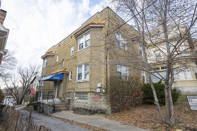
This unit is in the perfect location! Built in 1930, this unit is within walking distance to the University of Cincinnati! This unit features a garage parking spot, a large patio, and so much more. Just a few blocks away, Calhoun St. and W. McMillan St. are filled with shopping, restaurants, and entertainment options. A UC Shuttle Stop is right around the corner and South Campus is just a few streets away! Tenant pays $39 water, sewer and trash utility fee. Electric and gas are billed separately.
2405 Ohio Ave is an apartment community located in Hamilton County and the 45219 ZIP Code. This area is served by the Cincinnati Public Schools attendance zone.
Air Conditioning
High Speed Internet Access
Hardwood Floors
Refrigerator
In Clifton there’s plenty to do and see. The rolling hills, lush parks and green spaces, hip shopping, and affordable apartments create a vibrancy in Clifton that can’t be ignored.
In addition to its active art scene, the neighborhood is encompassing of Mount Storm Park, Edgewood Grove Park, and the Cincinnati State Technical and Community College. Locals enjoy the direct access to Interstate 75, making commutes in and around the city a breeze.
Clifton is just north of the 90-acre Burnet Woods Park and the University of Cincinnati campus. When you have a craving for something sweet or savory, head on over to the Clifton Gaslight District for every kind of cuisine imaginable. Clifton sits atop a hill overlooking the Northside, and Ludlow Avenue has been dubbed Cincinnati’s first “Main Street.
Learn more about living in CliftonCompare neighborhood and city base rent averages by bedroom.
| Clifton | Cincinnati, OH | |
|---|---|---|
| Studio | $827 | $1,066 |
| 1 Bedroom | $967 | $1,144 |
| 2 Bedrooms | $1,373 | $1,436 |
| 3 Bedrooms | $1,374 | $1,749 |
| Colleges & Universities | Distance | ||
|---|---|---|---|
| Colleges & Universities | Distance | ||
| Walk: | 15 min | 0.8 mi | |
| Drive: | 3 min | 1.3 mi | |
| Drive: | 9 min | 3.2 mi | |
| Drive: | 10 min | 3.4 mi |


Transportation options available in Cincinnati include Findlay Market-Race Station - Race & Elder, located 0.8 mile from 2405 Ohio Ave. 2405 Ohio Ave is near Cincinnati/Northern Kentucky International, located 16.1 miles or 32 minutes away.
| Transit / Subway | Distance | ||
|---|---|---|---|
| Transit / Subway | Distance | ||
| Walk: | 15 min | 0.8 mi | |
| Drive: | 3 min | 1.2 mi | |
| Drive: | 4 min | 1.2 mi | |
| Drive: | 3 min | 1.3 mi | |
| Drive: | 4 min | 1.6 mi |
| Commuter Rail | Distance | ||
|---|---|---|---|
| Commuter Rail | Distance | ||
|
|
Drive: | 7 min | 2.3 mi |
| Airports | Distance | ||
|---|---|---|---|
| Airports | Distance | ||
|
Cincinnati/Northern Kentucky International
|
Drive: | 32 min | 16.1 mi |
Scores provided by
Traffic
-Airport
-Businesses
-Scores provided by
HowLoud What is a Sound Score Rating? A Sound Score Rating aggregates noise caused by vehicle traffic, airplane traffic and local sources. How It WorksTime and distance from 2405 Ohio Ave.
| Shopping Centers | Distance | ||
|---|---|---|---|
| Shopping Centers | Distance | ||
| Drive: | 5 min | 1.6 mi | |
| Drive: | 6 min | 2.1 mi | |
| Drive: | 5 min | 2.2 mi |
| Parks and Recreation | Distance | ||
|---|---|---|---|
| Parks and Recreation | Distance | ||
|
William H. Taft National Historic Site
|
Walk: | 19 min | 1.0 mi |
|
Trailside Nature Center
|
Drive: | 4 min | 1.3 mi |
|
Cincinnati Zoo and Botanical Garden
|
Drive: | 3 min | 1.4 mi |
|
Burnet Woods
|
Drive: | 4 min | 1.6 mi |
|
Krohn Conservatory
|
Drive: | 6 min | 2.3 mi |
| Hospitals | Distance | ||
|---|---|---|---|
| Hospitals | Distance | ||
| Walk: | 16 min | 0.8 mi | |
| Drive: | 3 min | 1.4 mi | |
| Drive: | 4 min | 1.5 mi |
| Military Bases | Distance | ||
|---|---|---|---|
| Military Bases | Distance | ||
| Drive: | 70 min | 52.2 mi | |
| Drive: | 76 min | 57.2 mi | |
| Drive: | 78 min | 60.5 mi |
What Are Walk Score®, Transit Score®, and Bike Score® Ratings?
Walk Score® measures the walkability of any address. Transit Score® measures access to public transit. Bike Score® measures the bikeability of any address.
What is a Sound Score Rating?
A Sound Score Rating aggregates noise caused by vehicle traffic, airplane traffic and local sources.
2405 Ohio Ave
Cincinnati, OH 45219


