
$1,500 / Month
24 Lorraine Ave
Mount Vernon, NY 10553
2 Weeks Ago
Favorites
-
Bedrooms
2
-
Bathrooms
1
-
Square Feet
1,000 sq ft
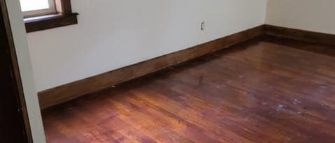
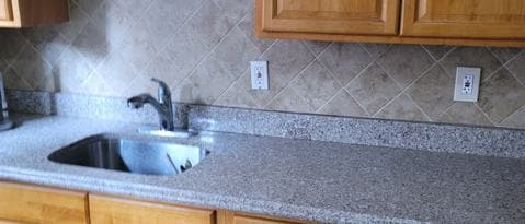
24 Lorraine Ave

Favorites
About This Home
---- SCHEDULE A SHOWING ONLINE AT: ----
24 Lorraine Ave is a condo located in Westchester County and the 10553 ZIP Code.
* Price shown is base rent and may not include non-optional fees and utilities.
Price, availability, fees, and any applicable rent special are subject to change without notice.
* Square footage definitions vary. Displayed square footage is approximate.
Contact
- Listed by Locayt
Location
Get Directions
The North Side area - which includes Mount Vernon - lies just north of the Bronx and several miles east of Yonkers and the Hudson River. This locale is home to a diverse and close-knit community, making for an incredible variety in shopping and restaurant options. Mount Vernon's proximity to the greater New York metropolitan area makes it a desirable location to live for commuters and those who like to take frequent jaunts into the city. Upscale high-rise apartments and more affordable mid-rise rentals make for a diverse rental scene as well.
Learn more about living in North Side
Education
| Colleges & Universities | Distance | ||
|---|---|---|---|
| Colleges & Universities | Distance | ||
| Drive: | 7 min | 2.9 mi | |
| Drive: | 6 min | 2.9 mi | |
| Drive: | 6 min | 2.9 mi | |
| Drive: | 6 min | 3.2 mi |
24 Lorraine Ave is within 6 minutes or 2.9 miles from Sarah Lawrence College. It is also near Iona College and The College of New Rochelle.
Transportation options available in Mount Vernon include Eastchester-Dyre Ave, located 2.1 miles from 24 Lorraine Ave. 24 Lorraine Ave is near LaGuardia, located 14.1 miles or 25 minutes away, and Westchester County, located 16.5 miles or 25 minutes away.
| Transit / Subway | Distance | ||
|---|---|---|---|
| Transit / Subway | Distance | ||
|
|
Drive: | 3 min | 2.1 mi |
|
|
Drive: | 4 min | 2.5 mi |
|
|
Drive: | 5 min | 2.9 mi |
|
|
Drive: | 5 min | 2.9 mi |
|
|
Drive: | 5 min | 3.3 mi |
| Commuter Rail | Distance | ||
|---|---|---|---|
| Commuter Rail | Distance | ||
|
|
Walk: | 11 min | 0.6 mi |
|
|
Drive: | 3 min | 1.3 mi |
|
|
Drive: | 3 min | 1.9 mi |
|
|
Drive: | 8 min | 4.7 mi |
|
|
Drive: | 9 min | 5.2 mi |
| Airports | Distance | ||
|---|---|---|---|
| Airports | Distance | ||
|
LaGuardia
|
Drive: | 25 min | 14.1 mi |
|
Westchester County
|
Drive: | 25 min | 16.5 mi |
Time and distance from 24 Lorraine Ave.
| Shopping Centers | Distance | ||
|---|---|---|---|
| Shopping Centers | Distance | ||
| Walk: | 14 min | 0.7 mi | |
| Drive: | 2 min | 1.2 mi | |
| Drive: | 5 min | 2.0 mi |
24 Lorraine Ave has 3 shopping centers within 2.0 miles, which is about a 5-minute walk. The miles and minutes will be for the farthest away property.
| Parks and Recreation | Distance | ||
|---|---|---|---|
| Parks and Recreation | Distance | ||
|
Seton Falls Park
|
Drive: | 5 min | 2.4 mi |
|
Davenport Neck Bird Sanctuary
|
Drive: | 7 min | 3.8 mi |
|
Pelham Bay Park
|
Drive: | 7 min | 4.1 mi |
|
Bartow-Pell Woods
|
Drive: | 8 min | 4.6 mi |
|
Van Cortlandt Park
|
Drive: | 11 min | 6.7 mi |
24 Lorraine Ave has 5 parks within 6.7 miles, including Seton Falls Park, Davenport Neck Bird Sanctuary, and Bartow-Pell Woods.
| Hospitals | Distance | ||
|---|---|---|---|
| Hospitals | Distance | ||
| Walk: | 20 min | 1.1 mi | |
| Drive: | 5 min | 2.5 mi | |
| Drive: | 10 min | 5.4 mi |
24 Lorraine Ave has 3 hospitals within 5.4 miles, the nearest is Montefiore Mount Vernon Hospital which is 1.1 miles away and a 20 minute walk.
| Military Bases | Distance | ||
|---|---|---|---|
| Military Bases | Distance | ||
| Drive: | 21 min | 12.1 mi |
24 Lorraine Ave is 12.1 miles and a 21 minute drive from Fort Totten US Govt Reservation.
You May Also Like
Similar Rentals Nearby
-
-
1 / 35

-
-
-
-

-

-

-
-


What Are Walk Score®, Transit Score®, and Bike Score® Ratings?
Walk Score® measures the walkability of any address. Transit Score® measures access to public transit. Bike Score® measures the bikeability of any address.
What is a Sound Score Rating?
A Sound Score Rating aggregates noise caused by vehicle traffic, airplane traffic and local sources

24 Lorraine Ave
Mount Vernon, NY 10553