
$4,100
/ Month
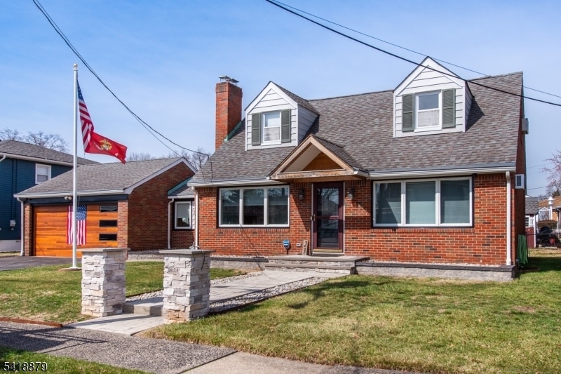
23 Lois Ave
Clifton, NJ 07014
1 Day Ago
|
Edit
Favorites
973-490-4567
-
Bedrooms
4
-
Bathrooms
1.5
-
Square Feet
--
-
Available
Available Now
Highlights
- Skyline View
- Wood Flooring
- Main Floor Bedroom
- High Ceiling
- Eat-In Kitchen
- Patio
23 Lois Ave

Favorites
About This Home
Available Now
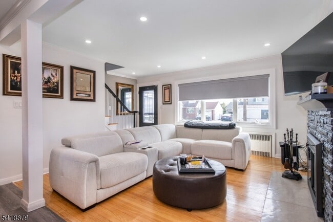
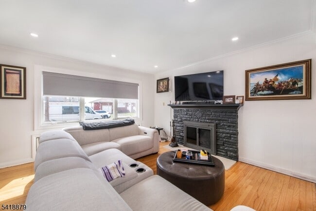
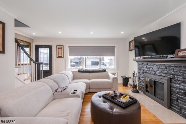
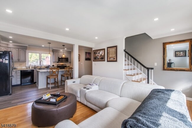
Fantastic 4-bedroom home in a beautiful neighborhood. Not your typical cape! This home has an open floor plan, modern kitchen with a center island, central vacuum, remote shades, hardwood floors on two levels, great closet space and a finished breezeway with porcelain radiant heated flooring, sliders to a covered patio and large back yard. Basement has washer/dryer and plenty of storage space. Quiet street, NY skyline views, near NYC express bus, shopping, restaurants and everything!
23 Lois Ave is a house located in Passaic County and the 07014 ZIP Code. This area is served by the Nutley Public School District attendance zone.
* Price shown is base rent. Excludes user-selected optional fees and variable or usage-based fees and required charges due at or prior to move-in or at move-out. Price, availability, fees, and any applicable rent special are subject to change without notice.
* Square footage definitions vary. Displayed square footage is approximate.
Home Details
Year Built
Built in 1953 | Remodeled
Bedrooms and Bathrooms
Main Floor Bedroom
1.5 Bathrooms
4 Bedrooms
Interior Spaces
Wood Flooring
High Ceiling
Living Room
Storage Room
Dining Room
2-Story Property
Blinds
Kitchen
Eat-In Kitchen
Kitchen Island
Gas Oven or Range
Microwave
Dishwasher
Laundry
Laundry Room
Dryer
Washer
Listing and Financial Details
Assessor Parcel Number 2502-00081-0011-00003-0000-
Tenant pays for cable t.v., electric, gas, heat, sewer, snow removal, water
Lot Details
7,841 Sq Ft Lot
Level Lot
Outdoor Features
Patio
Parking
2 Parking Spaces
Schools
Clifton High School
Utilities
Gas Water Heater
Cooling System Mounted In Outer Wall Opening
Views
Skyline Views
Community Details
Contact
- Listed by KAITLYN SIRACUSA | GardenStateMLS#NJ
- Phone Number
-
Source
Garden State Multiple Listing Service, LLC
Copyright © 2026 Garden State MLS, LLC. All rights reserved. All information provided by the listing agent/broker is deemed reliable but is not guaranteed and should be independently verified.
Location
Get Directions
The neighborhood of Rosemawr in Clifton, New Jersey serves as an ideal base for commuters with easy bus or train access to Manhattan, located 15 miles to the east, and Newark International Airport, 18 miles south. The area features single-family homes on tree-lined avenues and a few apartment buildings.
Shopping strips along Route 3 fill residents' daily needs. This area also houses Mighty Quinns Barbeque, where locals speak highly of the Brontosaurus ribs and burnt ends. Night owls appreciate Tick Tock Diner NJ, a no-frills diner open 24/7. Two upscale shopping malls sit within easy travel distance: Westfield Garden State Plaza located 15 minutes northeast and the Mall at Short Hills located 15 minutes southwest.
For entertainment activities closer to home, the Allwood Theatre just a short trip west of the area shows the latest movies in a classic old-school setting.
Learn more about living in Rosemawr
Amenities
- Air Conditioning
- Dishwasher
- Microwave
- Range
- Refrigerator
- Hardwood Floors
- Patio
Education
| Colleges & Universities | Distance | ||
|---|---|---|---|
| Colleges & Universities | Distance | ||
| Drive: | 5 min | 2.7 mi | |
| Drive: | 7 min | 3.3 mi | |
| Drive: | 6 min | 3.6 mi | |
| Drive: | 8 min | 4.8 mi |
23 Lois Ave is within 5 minutes or 2.7 miles from Passaic County C.C., Passaic. It is also near Felician College, Rutherford and Bergen C.C., Meadowlands.
Schools


Public Elementary School
Grades K-5
Nearby
Public High School
Grades 9-12
Nearby
Private High School
Grades 9-12
Nearby
School data provided by
 The GreatSchools Rating helps parents compare schools within a state based on a variety of school quality indicators and provides a helpful picture of how effectively each school serves all of its students. Ratings are on a scale of 1 (below average) to 10 (above average) and can include test scores, college readiness, academic progress, advanced courses, equity, discipline and attendance data. We also advise parents to visit schools, consider other information on school performance and programs, and consider family needs as part of the school selection process.
View GreatSchools Rating Methodology
Data provided by GreatSchools.org © 2026. All rights reserved.
View GreatSchools Rating Methodology
Data provided by GreatSchools.org © 2026. All rights reserved.
Transportation options available in Clifton include Branch Brook Park, located 4.3 miles from 23 Lois Ave. 23 Lois Ave is near Newark Liberty International, located 14.1 miles or 17 minutes away, and LaGuardia, located 20.6 miles or 37 minutes away.
| Transit / Subway | Distance | ||
|---|---|---|---|
| Transit / Subway | Distance | ||
|
|
Drive: | 9 min | 4.3 mi |
|
|
Drive: | 10 min | 4.7 mi |
|
|
Drive: | 10 min | 4.7 mi |
|
|
Drive: | 11 min | 5.3 mi |
|
|
Drive: | 10 min | 7.8 mi |
| Commuter Rail | Distance | ||
|---|---|---|---|
| Commuter Rail | Distance | ||
|
|
Drive: | 3 min | 1.5 mi |
|
|
Drive: | 4 min | 1.7 mi |
|
|
Drive: | 5 min | 2.6 mi |
|
|
Drive: | 5 min | 2.8 mi |
|
|
Drive: | 7 min | 4.9 mi |
| Airports | Distance | ||
|---|---|---|---|
| Airports | Distance | ||
|
Newark Liberty International
|
Drive: | 17 min | 14.1 mi |
|
LaGuardia
|
Drive: | 37 min | 20.6 mi |
Getting Around
 What do Walkability, Transit, Drivability, and Bikeability mean?
Walkability measures the walking distance to day-to-day needs.
Transit measures access to public transportation.
Drivability measures congestion, parking availability, and access to major roads.
Bikeability measures the suitability for cycling.
How It Works
What do Walkability, Transit, Drivability, and Bikeability mean?
Walkability measures the walking distance to day-to-day needs.
Transit measures access to public transportation.
Drivability measures congestion, parking availability, and access to major roads.
Bikeability measures the suitability for cycling.
How It Works
Moderately Walkable
Walkability
70
/ 100
Some Public Transit
Transit
40
/ 100
Exceptionally Drivable
Drivability
90
/ 100
Fairly Bikeable
Bikeability
40
/ 100
Scores provided by
Active
Soundscore™
68
/ 100
Traffic
BusyAirport
CalmBusinesses
ActiveScores provided by
HowLoud What is a Sound Score Rating? A Sound Score Rating aggregates noise caused by vehicle traffic, airplane traffic and local sources. How It WorksTime and distance from 23 Lois Ave.
| Shopping Centers | Distance | ||
|---|---|---|---|
| Shopping Centers | Distance | ||
| Walk: | 9 min | 0.5 mi | |
| Walk: | 10 min | 0.6 mi | |
| Walk: | 13 min | 0.7 mi |
23 Lois Ave has 3 shopping centers within 0.7 mile, which is about a 13-minute walk. The miles and minutes will be for the farthest away property.
| Parks and Recreation | Distance | ||
|---|---|---|---|
| Parks and Recreation | Distance | ||
|
Van Vleck House & Gardens
|
Drive: | 10 min | 4.9 mi |
|
Presby Memorial Iris Gardens
|
Drive: | 9 min | 5.0 mi |
|
Meadowlands Environment Center
|
Drive: | 13 min | 5.3 mi |
|
McDowell Observatory
|
Drive: | 13 min | 5.3 mi |
|
Richard W. DeKorte Park
|
Drive: | 14 min | 7.0 mi |
23 Lois Ave has 5 parks within 7.0 miles, including Presby Memorial Iris Gardens, Van Vleck House & Gardens, and Meadowlands Environment Center.
| Hospitals | Distance | ||
|---|---|---|---|
| Hospitals | Distance | ||
| Drive: | 6 min | 2.4 mi | |
| Drive: | 13 min | 5.9 mi | |
| Drive: | 9 min | 6.3 mi |
23 Lois Ave has 3 hospitals within 6.3 miles, the nearest is St. Mary's General Hospital which is 2.4 miles away and a 6 minute drive.
| Military Bases | Distance | ||
|---|---|---|---|
| Military Bases | Distance | ||
| Drive: | 26 min | 16.3 mi | |
| Drive: | 24 min | 18.5 mi |
23 Lois Ave is 16.3 miles from Governors Island Support Center, and is convenient to other military bases, including Military Ocean Terminal.
You May Also Like
How do I access Social Services in New Jersey?
Statewide service is free, confidential, multilingual and always open. Three easy ways to reach Social Services in NJ: Dial 2-1-1; text your zip code to 898-211; or chat at https://www.nj211.org
Similar Rentals Nearby
-
-

-

-

-
 4 Beds, 2 Baths$3,700Total Monthly PriceTotal Monthly Price NewPrices include all required monthly fees.66 Hoover Ave
 -
 5 Beds, 4 Baths$8,000Total Monthly PriceTotal Monthly Price NewPrices include all required monthly fees.258 Ridgewood Ave
 -
 5 Beds, 3 Baths$6,500Total Monthly PriceTotal Monthly Price NewPrices include all required monthly fees.99 Lincoln St
 -
 4 Beds, 3 Baths$4,000Total Monthly PriceTotal Monthly Price NewPrices include all required monthly fees.200 Prospect Ave
 -
 4 Beds, 1 Bath, 1,100 sq ft$2,400Total Monthly PriceTotal Monthly Price NewPrices include all required monthly fees.57 Silver St
 -
 6 Beds, 7 Baths$20,000Total Monthly PriceTotal Monthly Price NewPrices include all required monthly fees.91 Chestnut Ridge Rd
What Are Walk Score®, Transit Score®, and Bike Score® Ratings?
Walk Score® measures the walkability of any address. Transit Score® measures access to public transit. Bike Score® measures the bikeability of any address.
What is a Sound Score Rating?
A Sound Score Rating aggregates noise caused by vehicle traffic, airplane traffic and local sources.

23 Lois Ave
Clifton, NJ 07014