$2,800
/ Month
227 34th St
Brooklyn, NY 11232
Favorites
227 34th St

Favorites
Check Back Soon for Upcoming Availability
| Beds | Baths | Average SF |
|---|---|---|
| 1 Bedroom 1 Bedroom 1 Br | 1 Bath 1 Bath 1 Ba | — |
Fees and Policies
The fees listed below are community-provided and may exclude utilities or add-ons. All payments are made directly to the property and are non-refundable unless otherwise specified.
Details
Lease Options
-
12 Months
About This Property
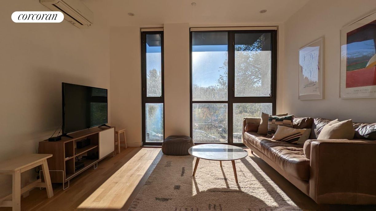
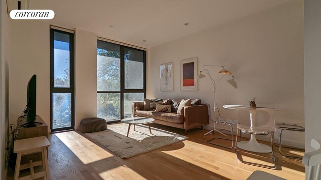
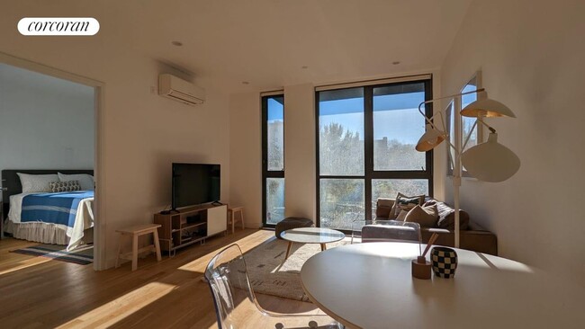
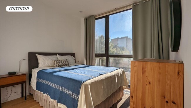
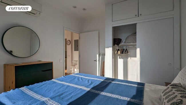
The most convenient listing on the market with amazing space and natural light. Furnished perfectly for your needs and is located next to the coveted 36th Street metro station. Neighbor to Sunset Park's iconic historical landmark, Greenwood Cemetery, this apartment will never be obstructed from the southern exposure through the floor-to-ceiling windows.Washer and dryer included!
227 34th St is a condo located in Kings County and the 11232 ZIP Code. This area is served by the New York City Geographic District #15 attendance zone.
Condo Features
- Air Conditioning
- Package Service
- Laundry Facilities
- Controlled Access
227 34th St,
Brooklyn,
NY
11232
Greenwood is a quaint neighborhood on the banks of the Hudson River and Upper Bay in Brooklyn, New York. This urban area is situated near Downtown Brooklyn with close proximity to major roads and subway stations that take you around town and to neighboring New York City boroughs.
Though a bustling urban neighborhood, Greenwood boasts walkable streets, good schools, and a safe community that’s favored by its residents. Greenwood is nestled near the Green Wood Cemetery, a sprawling area across nearly 500 acres that’s home to numerous notable figures.
Learn more about living in GreenwoodBelow are rent ranges for similar nearby apartments
Amenities
- Air Conditioning
- Package Service
- Laundry Facilities
- Controlled Access
Education
| Colleges & Universities | Distance | ||
|---|---|---|---|
| Colleges & Universities | Distance | ||
| Drive: | 8 min | 3.1 mi | |
| Drive: | 8 min | 3.1 mi | |
| Drive: | 8 min | 3.5 mi | |
| Drive: | 11 min | 4.3 mi |
227 34th St is within 8 minutes or 3.1 miles from ASA College Brooklyn. It is also near Brooklyn Law School and St. Francis College.
Schools


Public Elementary School
Grades PK-5
547 Students
Attendance Zone
Public High School
Grades 9-12
1,350 Students
Nearby
Private Elementary, Middle & High School
Grades PK-12
568 Students
Nearby
Private Elementary & Middle School
Grades K-8
Nearby
Private High School
Grades 9-12
Nearby
School data provided by
 The GreatSchools Rating helps parents compare schools within a state based on a variety of school quality indicators and provides a helpful picture of how effectively each school serves all of its students. Ratings are on a scale of 1 (below average) to 10 (above average) and can include test scores, college readiness, academic progress, advanced courses, equity, discipline and attendance data. We also advise parents to visit schools, consider other information on school performance and programs, and consider family needs as part of the school selection process.
View GreatSchools Rating Methodology
Data provided by GreatSchools.org © 2026. All rights reserved.
View GreatSchools Rating Methodology
Data provided by GreatSchools.org © 2026. All rights reserved.
Transportation options available in Brooklyn include 36 Street (D,M,N,R Line), located 0.2 mile from 227 34th St. 227 34th St is near LaGuardia, located 13.7 miles or 25 minutes away, and Newark Liberty International, located 17.2 miles or 30 minutes away.
| Transit / Subway | Distance | ||
|---|---|---|---|
| Transit / Subway | Distance | ||
|
|
Walk: | 3 min | 0.2 mi |
|
|
Walk: | 10 min | 0.6 mi |
|
|
Walk: | 12 min | 0.6 mi |
|
|
Drive: | 3 min | 1.2 mi |
|
|
Drive: | 3 min | 1.2 mi |
| Commuter Rail | Distance | ||
|---|---|---|---|
| Commuter Rail | Distance | ||
|
|
Drive: | 9 min | 3.1 mi |
|
|
Drive: | 13 min | 4.4 mi |
|
|
Drive: | 17 min | 8.6 mi |
|
|
Drive: | 19 min | 9.2 mi |
|
|
Drive: | 22 min | 9.8 mi |
| Airports | Distance | ||
|---|---|---|---|
| Airports | Distance | ||
|
LaGuardia
|
Drive: | 25 min | 13.7 mi |
|
Newark Liberty International
|
Drive: | 30 min | 17.2 mi |
Walkability Near 227 34th St Brooklyn, NY 11232
Getting Around
 What do Walkability, Transit, Drivability, and Bikeability mean?
Walkability measures the walking distance to day-to-day needs.
Transit measures access to public transportation.
Drivability measures congestion, parking availability, and access to major roads.
Bikeability measures the suitability for cycling.
How It Works
What do Walkability, Transit, Drivability, and Bikeability mean?
Walkability measures the walking distance to day-to-day needs.
Transit measures access to public transportation.
Drivability measures congestion, parking availability, and access to major roads.
Bikeability measures the suitability for cycling.
How It Works
Exceptionally Walkable
Walkability
100
/ 100
Exceptional Public Transit
Transit
100
/ 100
Moderately Drivable
Drivability
60
/ 100
Fairly Bikeable
Bikeability
50
/ 100
Scores provided by
-
Soundscore™
-
/ 100
Traffic
-Airport
-Businesses
-Scores provided by
HowLoud What is a Sound Score Rating? A Sound Score Rating aggregates noise caused by vehicle traffic, airplane traffic and local sources. How It WorksTime and distance from 227 34th St.
| Shopping Centers | Distance | ||
|---|---|---|---|
| Shopping Centers | Distance | ||
| Drive: | 6 min | 2.2 mi | |
| Drive: | 6 min | 2.8 mi | |
| Drive: | 8 min | 2.9 mi |
227 34th St has 3 shopping centers within 2.9 miles, which is about a 8-minute drive. The miles and minutes will be for the farthest away property.
| Parks and Recreation | Distance | ||
|---|---|---|---|
| Parks and Recreation | Distance | ||
|
Sunset Park
|
Walk: | 11 min | 0.6 mi |
|
Red Hook Park
|
Drive: | 5 min | 2.1 mi |
|
Gowanus Canal
|
Drive: | 6 min | 2.2 mi |
|
Coffey Park
|
Drive: | 6 min | 2.7 mi |
|
Waterfront Museum & Showboat Barge
|
Drive: | 7 min | 2.9 mi |
227 34th St has 5 parks within 2.9 miles, including Sunset Park, Red Hook Park, and Gowanus Canal.
| Hospitals | Distance | ||
|---|---|---|---|
| Hospitals | Distance | ||
| Drive: | 5 min | 1.7 mi | |
| Drive: | 7 min | 2.5 mi | |
| Drive: | 10 min | 3.5 mi |
227 34th St has 3 hospitals within 3.5 miles, the nearest is Maimonides Medical Center which is 1.7 miles away and a 5 minute drive.
| Military Bases | Distance | ||
|---|---|---|---|
| Military Bases | Distance | ||
| Drive: | 10 min | 4.5 mi | |
| Drive: | 12 min | 5.8 mi | |
| Drive: | 18 min | 8.7 mi |
227 34th St has 3 military bases within 8.7 miles, the nearest is Fort Hamilton which is 4.5 miles away and a 10 minute drive.
You May Also Like
Similar Rentals Nearby


What Are Walk Score®, Transit Score®, and Bike Score® Ratings?
Walk Score® measures the walkability of any address. Transit Score® measures access to public transit. Bike Score® measures the bikeability of any address.
What is a Sound Score Rating?
A Sound Score Rating aggregates noise caused by vehicle traffic, airplane traffic and local sources.

227 34th St
Brooklyn, NY 11232