
$1,700
/ Month
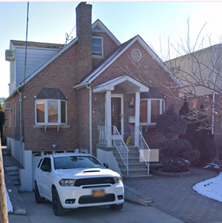
2234 Kingsland Ave Unit 2234 Kingsland Ave
Bronx, NY 10469
2 Weeks Ago
|
Edit
Favorites
2234 Kingsland Ave Unit 2234 Kingsland Ave

Favorites
Check Back Soon for Upcoming Availability
| Beds | Baths | Average SF |
|---|---|---|
| Studio Studio 0 Br | 1 Bath 1 Bath 1 Ba | 600 SF |
Fees and Policies
The fees below are based on community-supplied data and may exclude additional fees and utilities.
- Parking
-
Street--
Details
Utilities Included
-
Gas
-
Water
-
Electricity
-
Heat
-
Trash Removal
-
Air Conditioning
About This Property
Ample street parking, walking proximity to Bx31 bus and 5 subway line. Walking distance to Eastchester road: pharmacy, Subway, Dunkin Donuts, deli.
2234 Kingsland Ave is an apartment community located in Bronx County and the 10469 ZIP Code. This area is served by the New York City Geographic District #11 attendance zone.
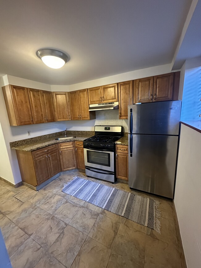
Apartment Features
- Smoke Free
- Fireplace
Location
Get Directions
Pelham Gardens is a walkable neighborhood in the Bronx. It’s so easy in fact – its boundaries make up less than half a square mile – so put on your walking shoes and start exploring! On your journey, you’ll discover a bevy of oak trees alongside city streets, plus numerous medical practices and area hospitals.
Subway Line 5 is the primary public transportation route of Pelham Gardens. Just a short drive or bus ride away are the restaurants and shops of the Bay Plaza Shopping Center. The Bronx Zoo and New York Botanical Gardens are within walking distance. Popular eateries in Pelham Gardens include Italian-style fare at Fratelli on Eastchester Road and Sal & Dom’s Pastry Shop on Allerton Avenue.
Learn more about living in Pelham GardensBelow are rent ranges for similar nearby apartments
Amenities
- Smoke Free
- Fireplace
Expenses
Utilities Included
Gas, Water, Electricity, Heat, Trash Removal, Air Conditioning
Included
Education
| Colleges & Universities | Distance | ||
|---|---|---|---|
| Colleges & Universities | Distance | ||
| Walk: | 15 min | 0.8 mi | |
| Drive: | 9 min | 2.9 mi | |
| Drive: | 10 min | 4.6 mi | |
| Drive: | 11 min | 4.9 mi |
2234 Kingsland Ave Unit 2234 Kingsland Ave is within 15 minutes or 0.8 mile from Yeshiva Univ., Resnick. It is also near Fordham University, Rose Hill and Monroe College, Bronx Campus.
Schools


Public Elementary School
Grades PK-5
482 Students
Nearby
Public Elementary School
Grades PK-5
543 Students
Attendance Zone
Charter Middle & High School
Grades 6-12
615 Students
Nearby
Public Middle School
Grades 6-8
291 Students
Attendance Zone
Public Middle School
Grades 6-8
421 Students
Attendance Zone
Private Elementary, Middle & High School
Grades K-12
187 Students
Nearby
Private Elementary & Middle School
Grades PK-8
Nearby
School data provided by
 The GreatSchools Rating helps parents compare schools within a state based on a variety of school quality indicators and provides a helpful picture of how effectively each school serves all of its students. Ratings are on a scale of 1 (below average) to 10 (above average) and can include test scores, college readiness, academic progress, advanced courses, equity, discipline and attendance data. We also advise parents to visit schools, consider other information on school performance and programs, and consider family needs as part of the school selection process.
View GreatSchools Rating Methodology
Data provided by GreatSchools.org © 2025. All rights reserved.
View GreatSchools Rating Methodology
Data provided by GreatSchools.org © 2025. All rights reserved.
Transportation options available in Bronx include Pelham Parkway (5 Line), located 1.0 mile from 2234 Kingsland Ave Unit 2234 Kingsland Ave. 2234 Kingsland Ave Unit 2234 Kingsland Ave is near LaGuardia, located 10.0 miles or 19 minutes away, and John F Kennedy International, located 17.5 miles or 25 minutes away.
| Transit / Subway | Distance | ||
|---|---|---|---|
| Transit / Subway | Distance | ||
|
|
Walk: | 18 min | 1.0 mi |
|
|
Drive: | 3 min | 1.2 mi |
|
|
Walk: | 25 min | 1.3 mi |
|
|
Drive: | 3 min | 1.4 mi |
|
|
Drive: | 4 min | 1.6 mi |
| Commuter Rail | Distance | ||
|---|---|---|---|
| Commuter Rail | Distance | ||
|
|
Drive: | 5 min | 2.7 mi |
|
|
Drive: | 8 min | 2.9 mi |
|
|
Drive: | 8 min | 4.0 mi |
|
|
Drive: | 9 min | 4.4 mi |
|
|
Drive: | 10 min | 4.8 mi |
| Airports | Distance | ||
|---|---|---|---|
| Airports | Distance | ||
|
LaGuardia
|
Drive: | 19 min | 10.0 mi |
|
John F Kennedy International
|
Drive: | 25 min | 17.5 mi |
Time and distance from 2234 Kingsland Ave Unit 2234 Kingsland Ave.
| Shopping Centers | Distance | ||
|---|---|---|---|
| Shopping Centers | Distance | ||
| Walk: | 10 min | 0.6 mi | |
| Walk: | 16 min | 0.8 mi | |
| Walk: | 16 min | 0.9 mi |
2234 Kingsland Ave Unit 2234 Kingsland Ave has 3 shopping centers within 0.9 mile, which is about a 16-minute walk. The miles and minutes will be for the farthest away property.
| Parks and Recreation | Distance | ||
|---|---|---|---|
| Parks and Recreation | Distance | ||
|
Pelham Bay Park
|
Drive: | 5 min | 2.3 mi |
|
Bartow-Pell Woods
|
Drive: | 7 min | 2.8 mi |
|
Seton Falls Park
|
Drive: | 6 min | 2.9 mi |
|
Bronx Zoo
|
Drive: | 9 min | 3.5 mi |
|
Bronx Park
|
Drive: | 12 min | 4.7 mi |
2234 Kingsland Ave Unit 2234 Kingsland Ave has 5 parks within 4.7 miles, including Bronx Park, Seton Falls Park, and Pelham Bay Park.
| Hospitals | Distance | ||
|---|---|---|---|
| Hospitals | Distance | ||
| Drive: | 3 min | 1.2 mi | |
| Drive: | 4 min | 1.6 mi | |
| Drive: | 7 min | 3.3 mi |
2234 Kingsland Ave Unit 2234 Kingsland Ave has 3 hospitals within 3.3 miles, the nearest is Bronx Psychiatric Center which is 1.2 miles away and a 3 minute drive.
| Military Bases | Distance | ||
|---|---|---|---|
| Military Bases | Distance | ||
| Drive: | 15 min | 8.0 mi |
2234 Kingsland Ave Unit 2234 Kingsland Ave is 8.0 miles and a 15 minute drive from Fort Totten US Govt Reservation.
You May Also Like
Similar Rentals Nearby


What Are Walk Score®, Transit Score®, and Bike Score® Ratings?
Walk Score® measures the walkability of any address. Transit Score® measures access to public transit. Bike Score® measures the bikeability of any address.
What is a Sound Score Rating?
A Sound Score Rating aggregates noise caused by vehicle traffic, airplane traffic and local sources

2234 Kingsland Ave
Bronx, NY 10469