-
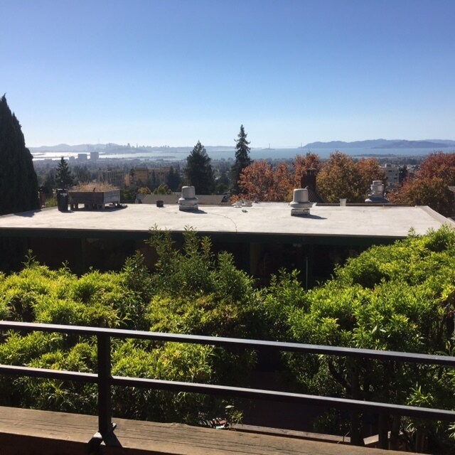
Fabulous bay views
22 Panoramic Way
22 Panoramic Way,
Berkeley,
CA
94704
2 Weeks Ago
Favorites
22 Panoramic Way

Favorites
Check Back Soon for Upcoming Availability
Fees and Policies
The fees below are based on community-supplied data and may exclude additional fees and utilities.
- Parking
-
Surface Lot$100/mo
Details
Lease Options
-
12 Months
About 22 Panoramic Way Berkeley, CA 94704
Near UC Berkeley, in the first block of Panoramic Way, just a few steps down from the sidewalk, step into this fabulous 2bd/2bath VIEW apartment. There is a spacious living area with wood-burning fireplace, open plan kitchen, dining area, two large bedrooms, two full baths, west facing deck and sweeping views. Owner pays trash/sewer and water. Resident pays PGE, cable, internet. 1 year lease. Laundry facilities on-site (coin-op) Parking may be available for an additional fee (please ask about availability)
22 Panoramic Way is an apartment community located in Alameda County and the 94704 ZIP Code.
Apartment Features
- Smoke Free
- Laundry Facilities
Location
Get Directions
The Southside community is located near the University of California, Berkeley. Students and residents can enjoy a variety of fare offered at restaurants that surround this 40,000-student public research campus. Public transportation is abound thanks to the Bay Area Rapid Transit rail station and bus stops near Southside.
You’ll discover numerous coffee shops, two cinemas, and cool museums near the college’s campus buildings and bookstores. Residents and students are close by to the Claremont Canyon Regional Preserve, which is an exceptional hiking destination that overlooks the San Francisco Bay.
Learn more about living in SouthsideBelow are rent ranges for similar nearby apartments
| Beds | Average Size | Lowest | Typical | Premium |
|---|---|---|---|---|
| Studio Studio Studio | 1152 Sq Ft | $1,070 | $1,558 | $1,995 |
| 1 Bed 1 Bed 1 Bed | 443 Sq Ft | $829 | $1,673 | $2,800 |
| 2 Beds 2 Beds 2 Beds | 603-612 Sq Ft | $821 | $2,459 | $3,700 |
| 3 Beds 3 Beds 3 Beds | 849-881 Sq Ft | $1,417 | $4,753 | $6,400 |
| 4 Beds 4 Beds 4 Beds | 2112 Sq Ft | $995 | $4,356 | $11,995 |
Amenities
- Smoke Free
- Laundry Facilities
Expenses
Recurring
Unassigned Surface Lot Parking
$100
Education
| Colleges & Universities | Distance | ||
|---|---|---|---|
| Colleges & Universities | Distance | ||
| Walk: | 14 min | 0.8 mi | |
| Drive: | 5 min | 1.7 mi | |
| Drive: | 12 min | 4.0 mi | |
| Drive: | 13 min | 5.7 mi |
22 Panoramic Way is within 14 minutes or 0.8 mile from UC Berkeley. It is also near Berkeley City College and Samuel Merritt University.
Transportation options available in Berkeley include Downtown Berkeley, located 1.6 miles from 22 Panoramic Way. 22 Panoramic Way is near Metro Oakland International, located 14.8 miles or 24 minutes away, and San Francisco International, located 25.3 miles or 42 minutes away.
| Transit / Subway | Distance | ||
|---|---|---|---|
| Transit / Subway | Distance | ||
|
|
Drive: | 5 min | 1.6 mi |
|
|
Drive: | 5 min | 1.6 mi |
|
|
Drive: | 6 min | 2.1 mi |
|
|
Drive: | 8 min | 2.4 mi |
|
|
Drive: | 7 min | 2.5 mi |
| Commuter Rail | Distance | ||
|---|---|---|---|
| Commuter Rail | Distance | ||
|
|
Drive: | 10 min | 3.3 mi |
|
|
Drive: | 12 min | 3.9 mi |
|
|
Drive: | 13 min | 6.5 mi |
| Drive: | 20 min | 9.8 mi | |
| Drive: | 23 min | 12.8 mi |
| Airports | Distance | ||
|---|---|---|---|
| Airports | Distance | ||
|
Metro Oakland International
|
Drive: | 24 min | 14.8 mi |
|
San Francisco International
|
Drive: | 42 min | 25.3 mi |
Time and distance from 22 Panoramic Way.
| Shopping Centers | Distance | ||
|---|---|---|---|
| Shopping Centers | Distance | ||
| Drive: | 3 min | 1.1 mi | |
| Drive: | 4 min | 1.4 mi | |
| Drive: | 5 min | 1.8 mi |
22 Panoramic Way has 3 shopping centers within 1.8 miles, which is about a 5-minute drive. The miles and minutes will be for the farthest away property.
| Parks and Recreation | Distance | ||
|---|---|---|---|
| Parks and Recreation | Distance | ||
|
People's Park
|
Walk: | 13 min | 0.7 mi |
|
Willard Park
|
Walk: | 19 min | 1.0 mi |
|
University and Jepson Herbaria
|
Drive: | 6 min | 1.6 mi |
|
Essig Museum of Entomology
|
Drive: | 6 min | 1.6 mi |
|
UC Berkeley Museum of Paleontology
|
Drive: | 6 min | 1.6 mi |
22 Panoramic Way has 5 parks within 1.6 miles, including People's Park, University and Jepson Herbaria, and Essig Museum of Entomology.
| Hospitals | Distance | ||
|---|---|---|---|
| Hospitals | Distance | ||
| Drive: | 4 min | 1.4 mi | |
| Drive: | 9 min | 3.0 mi | |
| Drive: | 11 min | 3.6 mi |
22 Panoramic Way has 3 hospitals within 3.6 miles, the nearest is Alta Bates Summit Medical Center - Alta Bates Campus which is 1.4 miles away and a 4 minute drive.
| Military Bases | Distance | ||
|---|---|---|---|
| Military Bases | Distance | ||
| Drive: | 14 min | 4.7 mi | |
| Drive: | 20 min | 8.2 mi |
22 Panoramic Way is 4.7 miles from Military Reservation, and is convenient to other military bases, including Oakland Army Base.
You May Also Like
Similar Rentals Nearby


What Are Walk Score®, Transit Score®, and Bike Score® Ratings?
Walk Score® measures the walkability of any address. Transit Score® measures access to public transit. Bike Score® measures the bikeability of any address.
What is a Sound Score Rating?
A Sound Score Rating aggregates noise caused by vehicle traffic, airplane traffic and local sources