
$1,500 / Month
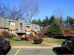
219 High Path Rd
Windsor, CT 06095
2 Weeks Ago
Favorites
219 High Path Rd

Favorites
Check Back Soon for Upcoming Availability
| Beds | Baths | Average SF |
|---|---|---|
| 2 Bedrooms 2 Bedrooms 2 Br | 2 Baths 2 Baths 2 Ba | 1,200 SF |
Fees and Policies
The fees below are based on community-supplied data and may exclude additional fees and utilities.
- Cats Allowed
-
Fees not specified
-
Weight limit--
-
Pet Limit--
- Parking
-
Surface Lot--
Details
Utilities Included
-
Water
-
Heat
-
Trash Removal
-
Sewer
About This Property
Great location two full bath 2nd story. Heat Hot water including in rent.
219 High Path Rd is a condo located in Hartford County and the 06095 ZIP Code.
Condo Features
Dishwasher
Refrigerator
Tub/Shower
Heating
- Heating
- Storage Space
- Tub/Shower
- Dishwasher
- Kitchen
- Range
- Refrigerator
- Instant Hot Water
- Family Room
- Laundry Facilities
Location
Get Directions
The towns of Bloomfield and Windsor border the Connecticut River, with Bloomfield directly north of the University of Hartford. This area is rich with history and provides a fantastic, tree-filled setting dotted with historic architecture. Bloomfield is bordered by Penwood State Park and Talcott Mountain State Park, both of which offer stunning views and terrific places for hiking and nature-watching. As the first English settlement in Connecticut, Windsor was settled in 1633. It still features its colonial charm with fantastic historic sites like the Oliver Ellsworth Homestead, a National Historic Landmark dating to 1781, and the Hezekiah Chaffee House, a historic house museum that was built around 1765.
Bloomfield and Windsor are located on the north side of Hartford, and Interstate 91 divides these two towns for easy commutes to downtown, just six miles away.
Learn more about living in Bloomfield/WindsorBelow are rent ranges for similar nearby apartments
| Beds | Average Size | Lowest | Typical | Premium |
|---|---|---|---|---|
| Studio Studio Studio | 615-623 Sq Ft | $1,755 | $1,888 | $1,920 |
| 1 Bed 1 Bed 1 Bed | 802-804 Sq Ft | $1,550 | $2,244 | $2,949 |
| 2 Beds 2 Beds 2 Beds | 1155-1168 Sq Ft | $1,400 | $2,742 | $4,025 |
| 3 Beds 3 Beds 3 Beds | 1766-1799 Sq Ft | $1,800 | $3,577 | $5,500 |
| 4 Beds 4 Beds 4 Beds | 4065-4154 Sq Ft | $3,577 | $5,919 | $9,490 |
Amenities
- Heating
- Storage Space
- Tub/Shower
- Dishwasher
- Kitchen
- Range
- Refrigerator
- Instant Hot Water
- Family Room
- Laundry Facilities
Expenses
Utilities Included
Water, Heat, Trash Removal, Sewer
Included
Education
| Colleges & Universities | Distance | ||
|---|---|---|---|
| Colleges & Universities | Distance | ||
| Drive: | 16 min | 10.6 mi | |
| Drive: | 19 min | 12.0 mi | |
| Drive: | 21 min | 12.7 mi | |
| Drive: | 20 min | 13.5 mi |
219 High Path Rd is within 16 minutes or 10.6 miles from University of Connecticut. It is also near University of Connecticut and University of Hartford.
You May Also Like
Similar Rentals Nearby


What Are Walk Score®, Transit Score®, and Bike Score® Ratings?
Walk Score® measures the walkability of any address. Transit Score® measures access to public transit. Bike Score® measures the bikeability of any address.
What is a Sound Score Rating?
A Sound Score Rating aggregates noise caused by vehicle traffic, airplane traffic and local sources

219 High Path Rd
Windsor, CT 06095