
$4,450
/ Month
2138 Powhatan St
Falls Church, VA 22043
2 Weeks Ago
Favorites
2138 Powhatan St

Favorites
Check Back Soon for Upcoming Availability
| Beds | Baths | Average SF |
|---|---|---|
| 3 Bedrooms 3 Bedrooms 3 Br | 2 Baths 2 Baths 2 Ba | 2,394 SF |
Fees and Policies
The fees below are based on community-supplied data and may exclude additional fees and utilities.
- Dogs Allowed
-
Fees not specified
- Cats Allowed
-
Fees not specified
About This Property
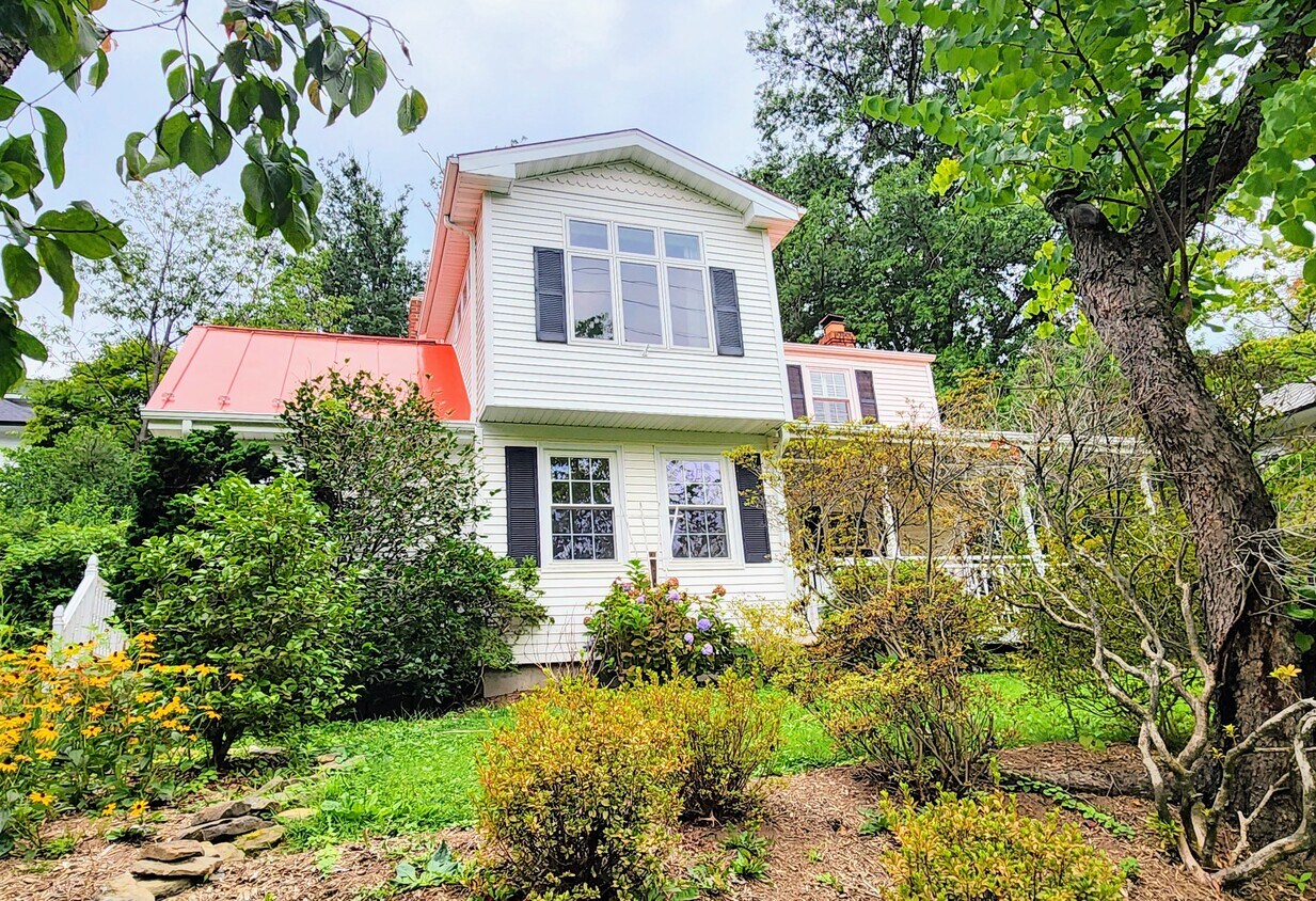
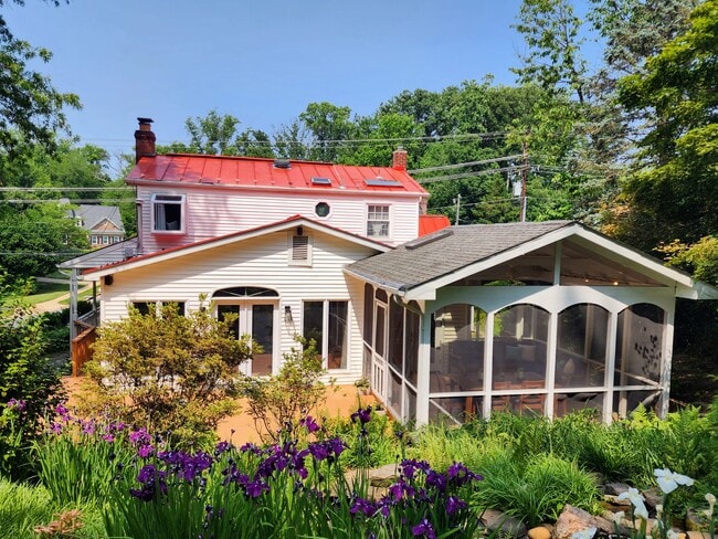
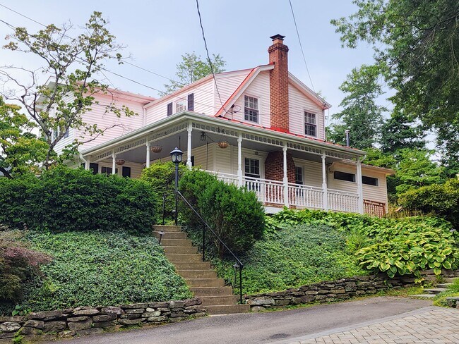
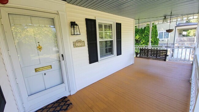
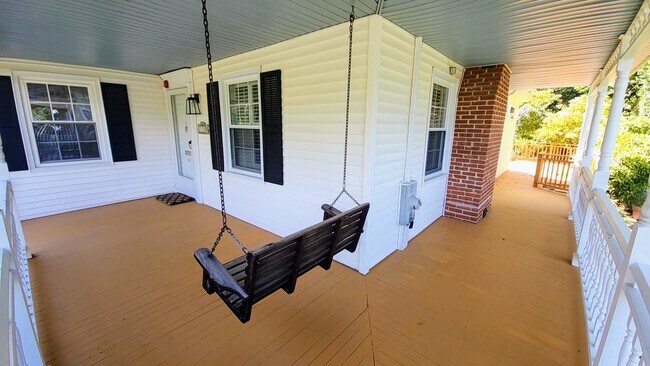
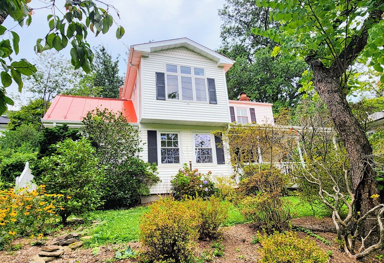
Three level expanded farmhouse centrally located in Falls Church. Flexible floorplan with multiple living and dining spaces including two fireplaces on the main level. Remodeled kitchen with granite counters, eat-in bar and stainless steel/integrated appliances. Side entrance leads into a large mudroom with full sized laundry and home office space. Huge wrap around porch and screened in back patio. Tranquil backyard with mature landscaping including waterfall and pond. All bedrooms and renovated bath located on second floor. Oversized primary bedroom easily accommodates a separate sitting area and the small third bedroom is ideal for a home office or nursery. Finished basement with built-in bar and wine wall. Numerous custom storage solutions throughout and extra large shed. Fantastic location moments from D.C., Tysons, McLean and Arlington with easy access to I-66 and I-495. Walking distance to EFC metro station and multiple bus routes. Haycock Elementary, Longfellow Middle, McLean High School pyramid. Trash/recycling, lawncare and pond maintenance included. Non-smoking property. Pets on a case by case basis. Please note the backyard is not fully enclosed. 12 month minimum w/preference for longer term lease.
2138 Powhatan St is a house located in Fairfax County and the 22043 ZIP Code. This area is served by the Fairfax County Public Schools attendance zone.
House Features
- Washer/Dryer
- Washer/Dryer Hookup
- Dishwasher
Location
Get Directions
With its rolling hills, mature trees, and neat houses on tidy lawns, Idylwood is aptly named: it is both idyllic and wooded. But there's more to this picture-perfect neighborhood than meets the eye. Sure, it has paved bicycle trails, wide sidewalks, and beautiful parks -- but it is also strategically located. Idylwood is on the west side of Falls Church, framed by I-66 and I-495. Washington DC is directly west, roughly 12 miles away. The Metro train's Orange line takes commuters to the city in about 20 minutes, making Idylwood perfect for those who work in the city but want a quieter place to call home.
Learn more about living in IdylwoodBelow are rent ranges for similar nearby apartments
| Beds | Average Size | Lowest | Typical | Premium |
|---|---|---|---|---|
| Studio Studio Studio | 537 Sq Ft | $1,350 | $2,253 | $3,157 |
| 1 Bed 1 Bed 1 Bed | 687 Sq Ft | $1,695 | $2,439 | $3,354 |
| 2 Beds 2 Beds 2 Beds | 1053 Sq Ft | $2,095 | $3,320 | $4,660 |
| 3 Beds 3 Beds 3 Beds | 1200 Sq Ft | $2,600 | $3,840 | $6,750 |
| 4 Beds 4 Beds 4 Beds | 3701 Sq Ft | $4,199 | $5,470 | $8,300 |
Amenities
- Washer/Dryer
- Washer/Dryer Hookup
- Dishwasher
Education
| Colleges & Universities | Distance | ||
|---|---|---|---|
| Colleges & Universities | Distance | ||
| Drive: | 5 min | 2.4 mi | |
| Drive: | 10 min | 4.7 mi | |
| Drive: | 12 min | 5.7 mi | |
| Drive: | 12 min | 6.1 mi |
2138 Powhatan St is within 5 minutes or 2.4 miles from Marymount University. It is also near George Mason Univ., Arlington and GWU, Mount Vernon.
Schools


Public Elementary School
Grades PK-6
872 Students
Attendance Zone
Public Middle School
Grades 7-8
1,225 Students
Attendance Zone
Public High School
Grades 9-12
2,441 Students
Attendance Zone
Private Elementary & Middle School
Grades K-8
138 Students
Nearby
Private Elementary School
Grades PK-K
104 Students
Nearby
Private High School
Grades 9-12
1,193 Students
Nearby
School data provided by
 The GreatSchools Rating helps parents compare schools within a state based on a variety of school quality indicators and provides a helpful picture of how effectively each school serves all of its students. Ratings are on a scale of 1 (below average) to 10 (above average) and can include test scores, college readiness, academic progress, advanced courses, equity, discipline and attendance data. We also advise parents to visit schools, consider other information on school performance and programs, and consider family needs as part of the school selection process.
View GreatSchools Rating Methodology
Data provided by GreatSchools.org © 2025. All rights reserved.
View GreatSchools Rating Methodology
Data provided by GreatSchools.org © 2025. All rights reserved.
Transportation options available in Falls Church include Ballston-Mu, located 3.9 miles from 2138 Powhatan St. 2138 Powhatan St is near Ronald Reagan Washington Ntl, located 11.3 miles or 20 minutes away, and Washington Dulles International, located 20.1 miles or 34 minutes away.
| Transit / Subway | Distance | ||
|---|---|---|---|
| Transit / Subway | Distance | ||
|
|
Drive: | 8 min | 3.9 mi |
|
|
Drive: | 10 min | 4.2 mi |
|
|
Drive: | 9 min | 4.4 mi |
|
|
Drive: | 11 min | 5.9 mi |
|
|
Drive: | 16 min | 8.7 mi |
| Commuter Rail | Distance | ||
|---|---|---|---|
| Commuter Rail | Distance | ||
|
|
Drive: | 21 min | 9.4 mi |
|
|
Drive: | 17 min | 10.0 mi |
|
|
Drive: | 18 min | 10.1 mi |
|
|
Drive: | 18 min | 10.1 mi |
|
|
Drive: | 20 min | 10.9 mi |
| Airports | Distance | ||
|---|---|---|---|
| Airports | Distance | ||
|
Ronald Reagan Washington Ntl
|
Drive: | 20 min | 11.3 mi |
|
Washington Dulles International
|
Drive: | 34 min | 20.1 mi |
Time and distance from 2138 Powhatan St.
| Shopping Centers | Distance | ||
|---|---|---|---|
| Shopping Centers | Distance | ||
| Walk: | 7 min | 0.4 mi | |
| Walk: | 7 min | 0.4 mi | |
| Drive: | 5 min | 1.6 mi |
2138 Powhatan St has 3 shopping centers within 1.6 miles, which is about a 5-minute walk. The miles and minutes will be for the farthest away property.
| Parks and Recreation | Distance | ||
|---|---|---|---|
| Parks and Recreation | Distance | ||
|
W&OD Trail
|
Drive: | 4 min | 1.5 mi |
|
Rock Spring Park
|
Drive: | 3 min | 1.6 mi |
|
Benjamin Banneker Park
|
Drive: | 4 min | 1.7 mi |
|
Parkhurst Park
|
Drive: | 5 min | 1.8 mi |
|
Lacey Woods Park
|
Drive: | 7 min | 2.8 mi |
2138 Powhatan St has 5 parks within 2.8 miles, including Rock Spring Park, W&OD Trail, and Benjamin Banneker Park.
| Hospitals | Distance | ||
|---|---|---|---|
| Hospitals | Distance | ||
| Drive: | 6 min | 2.4 mi | |
| Drive: | 7 min | 2.7 mi | |
| Drive: | 8 min | 3.0 mi |
2138 Powhatan St has 3 hospitals within 3.0 miles, the nearest is Virginia Hospital Center which is 2.4 miles away and a 6 minute drive.
| Military Bases | Distance | ||
|---|---|---|---|
| Military Bases | Distance | ||
| Drive: | 15 min | 6.8 mi |
2138 Powhatan St is 6.8 miles and a 15 minute drive from Fort Myer.
You May Also Like
Similar Rentals Nearby


What Are Walk Score®, Transit Score®, and Bike Score® Ratings?
Walk Score® measures the walkability of any address. Transit Score® measures access to public transit. Bike Score® measures the bikeability of any address.
What is a Sound Score Rating?
A Sound Score Rating aggregates noise caused by vehicle traffic, airplane traffic and local sources
2138 Powhatan St
Falls Church, VA 22043