

$1,100
/ Month
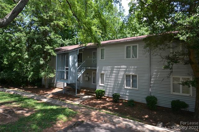
2013 Stoney Point Ln Unit 29
Charlotte, NC 28210
2 Weeks Ago
|
Edit
Favorites
2013 Stoney Point Ln Unit 29

Favorites
Check Back Soon for Upcoming Availability
| Beds | Baths | Average SF |
|---|---|---|
| 1 Bedroom 1 Bedroom 1 Br | 1 Bath 1 Bath 1 Ba | 667 SF |
About This Property
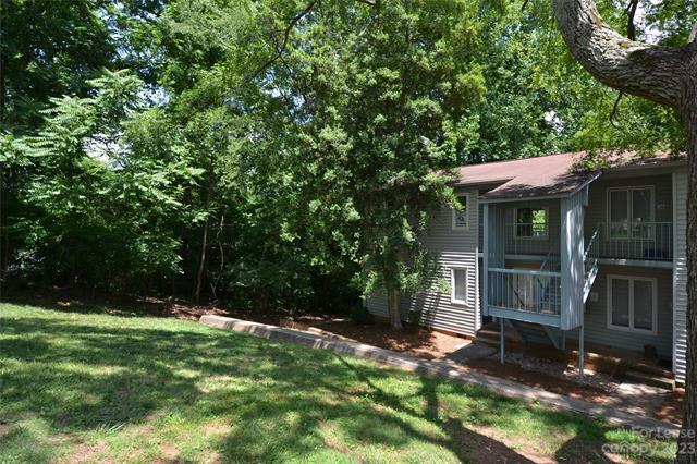
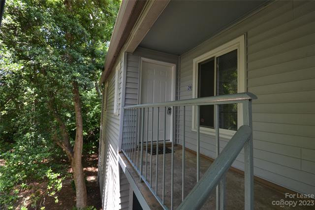
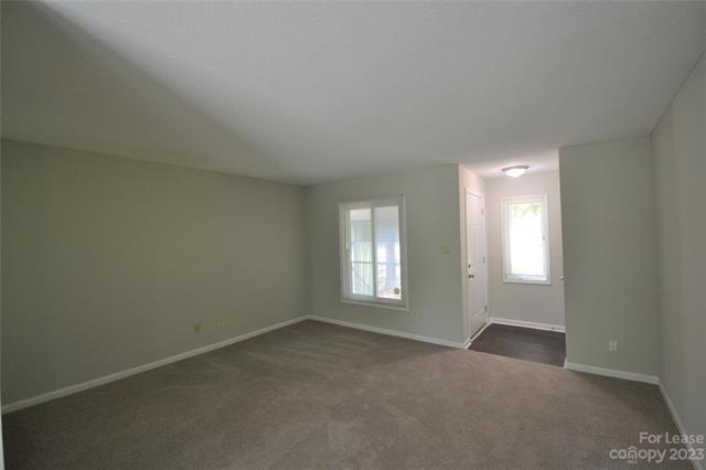
GREAT LOCATION! This second level end unit condo is convenient to the Rail Line and Public transportation, tons of restaurants and shopping. This lovely Condo host open living area with great room, dining area and Kitchen. Kitchen has stainless steel appliances, white cabinets and tile floors, Large bedroom with plenty of closet space. Common bathroom for the unit. Feel like you are in you own private tree house with the cute rear balcony that is surrounded by trees for privacy with the greenway behind the property!
2013 Stoney Point Ln is a condo located in Mecklenburg County and the 28210 ZIP Code. This area is served by the Charlotte-Mecklenburg attendance zone.
Location
Get Directions
Starmount Forest is a diverse suburban neighborhood about 10 miles south of Uptown Charlotte. Starmount Forest residents enjoy access to great schools and amenities not far from home. The 23-acre Huntingtowne Farms Park is nestled on the eastern part of the neighborhood, providing residents with tennis courts, a community garden, creekside trails, and more. Starmount Forest has something for every renter with highly affordable and upscale rental options in a variety of styles available in the neighborhood. Along with being only a few miles from some of the city’s best dining, shopping, and entertainment options in Uptown Charlotte, Starmount Forest is also convenient to the Charlotte Douglas International Airport.
Learn more about living in Starmount ForestBelow are rent ranges for similar nearby apartments
Education
| Colleges & Universities | Distance | ||
|---|---|---|---|
| Colleges & Universities | Distance | ||
| Drive: | 5 min | 2.0 mi | |
| Drive: | 14 min | 6.4 mi | |
| Drive: | 15 min | 8.5 mi | |
| Drive: | 17 min | 9.4 mi |
2013 Stoney Point Ln Unit 29 is within 5 minutes or 2.0 miles from Central Piedmont C.C., Harper. It is also near Queens University of Charlotte and Central Piedmont C.C., Central.
Schools


Public Elementary School
Grades PK-5
695 Students
Attendance Zone
Public Middle School
Grades 6-8
1,144 Students
Attendance Zone
Public High School
Grades 9-12
3,344 Students
Attendance Zone
Private Elementary, Middle & High School
Grades K-12
1,683 Students
Nearby
Private Elementary, Middle & High School
Grades 3-12
53 Students
Nearby
Private Elementary School
Grades PK-6
52 Students
Nearby
School data provided by
 The GreatSchools Rating helps parents compare schools within a state based on a variety of school quality indicators and provides a helpful picture of how effectively each school serves all of its students. Ratings are on a scale of 1 (below average) to 10 (above average) and can include test scores, college readiness, academic progress, advanced courses, equity, discipline and attendance data. We also advise parents to visit schools, consider other information on school performance and programs, and consider family needs as part of the school selection process.
View GreatSchools Rating Methodology
Data provided by GreatSchools.org © 2025. All rights reserved.
View GreatSchools Rating Methodology
Data provided by GreatSchools.org © 2025. All rights reserved.
Transportation options available in Charlotte include Sharon Road West, located 1.4 miles from 2013 Stoney Point Ln Unit 29. 2013 Stoney Point Ln Unit 29 is near Charlotte/Douglas International, located 10.1 miles or 20 minutes away, and Concord-Padgett Regional, located 25.5 miles or 39 minutes away.
| Transit / Subway | Distance | ||
|---|---|---|---|
| Transit / Subway | Distance | ||
|
|
Drive: | 3 min | 1.4 mi |
|
|
Walk: | 27 min | 1.4 mi |
|
|
Drive: | 4 min | 2.1 mi |
|
|
Drive: | 4 min | 2.3 mi |
|
|
Drive: | 6 min | 3.1 mi |
| Commuter Rail | Distance | ||
|---|---|---|---|
| Commuter Rail | Distance | ||
|
|
Drive: | 19 min | 9.7 mi |
|
|
Drive: | 37 min | 27.1 mi |
| Drive: | 51 min | 36.3 mi |
| Airports | Distance | ||
|---|---|---|---|
| Airports | Distance | ||
|
Charlotte/Douglas International
|
Drive: | 20 min | 10.1 mi |
|
Concord-Padgett Regional
|
Drive: | 39 min | 25.5 mi |
Time and distance from 2013 Stoney Point Ln Unit 29.
| Shopping Centers | Distance | ||
|---|---|---|---|
| Shopping Centers | Distance | ||
| Walk: | 10 min | 0.5 mi | |
| Drive: | 2 min | 1.1 mi | |
| Drive: | 3 min | 1.4 mi |
2013 Stoney Point Ln Unit 29 has 3 shopping centers within 1.4 miles, which is about a 3-minute drive. The miles and minutes will be for the farthest away property.
| Parks and Recreation | Distance | ||
|---|---|---|---|
| Parks and Recreation | Distance | ||
|
Briar Creek Greenway
|
Drive: | 10 min | 5.3 mi |
|
Wing Haven Gardens & Bird Sanctuary
|
Drive: | 12 min | 5.8 mi |
|
Ballantyne's Backyard
|
Drive: | 12 min | 6.0 mi |
|
Charlotte Nature Museum
|
Drive: | 13 min | 6.9 mi |
|
Brixham Park
|
Drive: | 12 min | 7.2 mi |
2013 Stoney Point Ln Unit 29 has 5 parks within 7.2 miles, including Briar Creek Greenway, Wing Haven Gardens & Bird Sanctuary, and Ballantyne's Backyard.
| Hospitals | Distance | ||
|---|---|---|---|
| Hospitals | Distance | ||
| Walk: | 12 min | 0.6 mi | |
| Drive: | 6 min | 3.5 mi | |
| Drive: | 14 min | 7.7 mi |
2013 Stoney Point Ln Unit 29 has 3 hospitals within 7.7 miles, the nearest is Strategic Behavioral Center - Charlotte which is 0.6 mile away and a 12 minute walk.
| Military Bases | Distance | ||
|---|---|---|---|
| Military Bases | Distance | ||
| Drive: | 124 min | 91.1 mi |
2013 Stoney Point Ln Unit 29 is 91.1 miles and a 124 minute drive from Fort Jackson.
You May Also Like
Similar Rentals Nearby


What Are Walk Score®, Transit Score®, and Bike Score® Ratings?
Walk Score® measures the walkability of any address. Transit Score® measures access to public transit. Bike Score® measures the bikeability of any address.
What is a Sound Score Rating?
A Sound Score Rating aggregates noise caused by vehicle traffic, airplane traffic and local sources

2013 Stoney Point Ln
Charlotte, NC 28210