
$4,500
/ Month
2013 N Oakland St
Arlington, VA 22207
Today
Favorites
703-939-7523
-
Bedrooms
3
-
Bathrooms
2.5
-
Square Feet
2,776 sq ft
-
Available
Available Now
Highlights
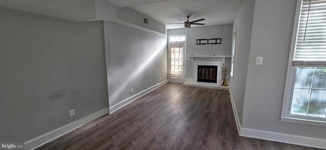
- Craftsman Architecture
- 1 Fireplace
- Luxury Vinyl Plank Tile Flooring
- Central Heating and Cooling System
- Partially Carpeted
- ENERGY STAR Qualified Washer
2013 N Oakland St

Favorites
About This Home
Available Now
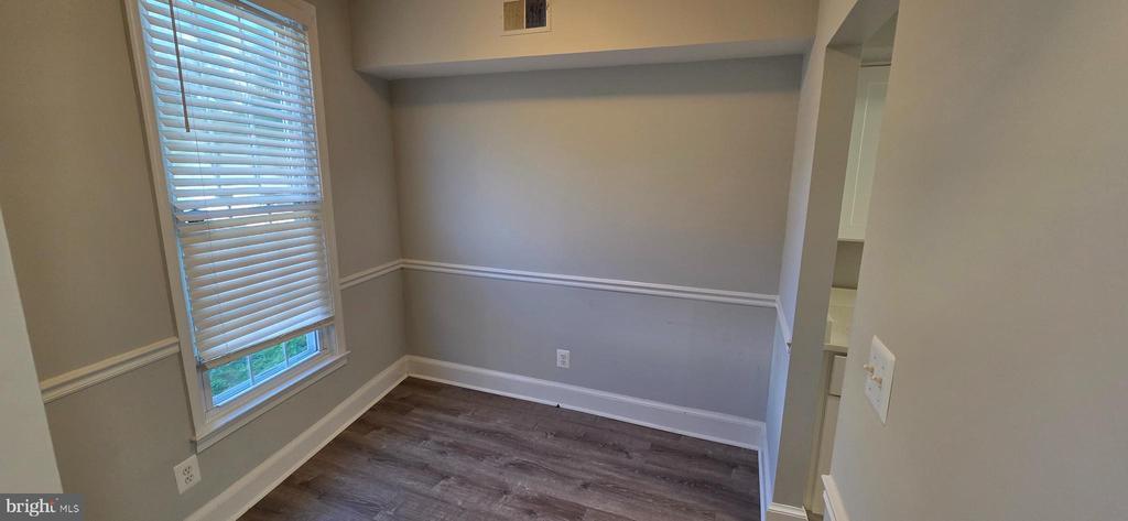
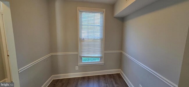
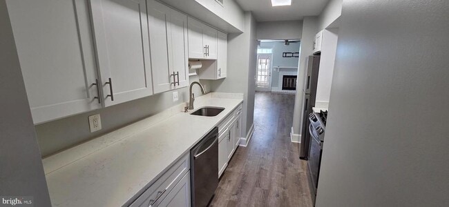
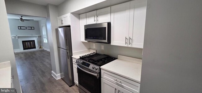
A 3-bed / 2.5 bath duplex available in Cherrydale, Arlington! Newly renovated throughout with brand new appliances and countertops in the kitchen, brand new LVP flooring and light fixtures on the main floor, and fresh paint throughout. Features a newly landscaped yard and driveway. Fantastic location: 1.5 miles from Clarendon Metro, 2 blocks from the shopping center, and near I-66. Just 2 short blocks from Hidden Pond and Cherry Valley Park. Don't miss out on this one!
2013 N Oakland St is a house located in Arlington County and the 22207 ZIP Code. This area is served by the Arlington County Public Schools attendance zone.
* Price shown is base rent. Excludes user-selected optional fees and variable or usage-based fees and required charges due at or prior to move-in or at move-out. Price, availability, fees, and any applicable rent special are subject to change without notice.
* Square footage definitions vary. Displayed square footage is approximate.
Home Details
Home Type
Semi-Detached or Twin Home
Year Built
Built in 1900 | Remodeled in 2022
Basement
Laundry in Basement
Bedrooms and Bathrooms
2.5 Bathrooms
3 Bedrooms
Flooring
Luxury Vinyl Plank Tile
Partially Carpeted
Home Design
Craftsman Architecture
Brick Exterior Construction
Vinyl Siding
Permanent Foundation
Interior Spaces
1 Fireplace
2,776 Sq Ft Home
Property has 3.5 Levels
Kitchen
Six Burner Stove
ENERGY STAR Qualified Refrigerator
Built-In Microwave
Dishwasher
Self-Cleaning Oven
Disposal
Laundry
Dryer
ENERGY STAR Qualified Washer
Listing and Financial Details
Security Deposit $4,500
12-Month Min and 24-Month Max Lease Term
Available 10/2/25
$55 Application Fee
Assessor Parcel Number 06-027-014
Residential Lease
Lot Details
6,142 Sq Ft Lot
Parking
Gravel Driveway
Schools
Washington-Liberty High School
Utilities
Central Heating and Cooling System
Natural Gas Water Heater
Community Details
Overview
No Home Owners Association
Property Manager
Cherrydale Subdivision
Pet Policy
Pets allowed on a case-by-case basis
Pet Deposit $250
Contact
- Listed by John V Malatesta III | Fairfax Realty
- Phone Number
- Contact
-
Source
 Bright MLS, Inc.
Copyright © 2025 Bright MLS, Inc.
Location
Get Directions
Amenities
- Fireplace
- Dishwasher
- Basement
Located less than two miles north of Arlington, Cherrydale is a picturesque neighborhood centered on the Five Points intersection, where Old Dominion Drive, Lee Highway, Military Road, and Quincy Street meet. Cherrydale’s past dates back to its founding in 1893, and the neighborhood still contains an array of historic homes that have since been luxuriously renovated.
Cherrydale boasts a variety of rental offerings, from elegant houses to modern apartments, on tranquil tree-lined streets. Although the neighborhood is largely residential, the Cherrydale community enjoys access to a host of shops and restaurants on Old Dominion Drive. Several popular parks are convenient to the neighborhood, including Hayes Park, Quincy Park, and Potomac Overlook Regional Park. Commuting from Cherrydale is a breeze with access to Interstate 66 and several nearby Metro stations.
Learn more about living in Cherrydale
Education
| Colleges & Universities | Distance | ||
|---|---|---|---|
| Colleges & Universities | Distance | ||
| Walk: | 20 min | 1.1 mi | |
| Drive: | 4 min | 1.7 mi | |
| Drive: | 8 min | 3.7 mi | |
| Drive: | 9 min | 4.6 mi |
2013 N Oakland St is within 20 minutes or 1.1 miles from George Mason Univ., Arlington. It is also near Marymount University and Georgetown University.
Schools


Public Elementary School
Grades PK-5
470 Students
Nearby
Public Middle School
Grades 6-8
1,053 Students
Nearby
Public High School
Grades 9-12
2,715 Students
Attendance Zone
Private Elementary & Middle School
Grades PK-8
467 Students
Nearby
Private Elementary, Middle & High School
Grades 1-12
378 Students
Nearby
School data provided by
 The GreatSchools Rating helps parents compare schools within a state based on a variety of school quality indicators and provides a helpful picture of how effectively each school serves all of its students. Ratings are on a scale of 1 (below average) to 10 (above average) and can include test scores, college readiness, academic progress, advanced courses, equity, discipline and attendance data. We also advise parents to visit schools, consider other information on school performance and programs, and consider family needs as part of the school selection process.
View GreatSchools Rating Methodology
Data provided by GreatSchools.org © 2025. All rights reserved.
View GreatSchools Rating Methodology
Data provided by GreatSchools.org © 2025. All rights reserved.
Transportation options available in Arlington include Virginia Square-Gmu, located 1.1 miles from 2013 N Oakland St. 2013 N Oakland St is near Ronald Reagan Washington Ntl, located 6.9 miles or 14 minutes away, and Washington Dulles International, located 23.6 miles or 37 minutes away.
| Transit / Subway | Distance | ||
|---|---|---|---|
| Transit / Subway | Distance | ||
|
|
Drive: | 3 min | 1.1 mi |
|
|
Drive: | 4 min | 1.2 mi |
|
|
Drive: | 4 min | 1.2 mi |
| Drive: | 5 min | 1.6 mi | |
|
|
Drive: | 5 min | 2.3 mi |
| Commuter Rail | Distance | ||
|---|---|---|---|
| Commuter Rail | Distance | ||
|
|
Drive: | 11 min | 5.6 mi |
|
|
Drive: | 12 min | 6.5 mi |
|
|
Drive: | 12 min | 6.5 mi |
|
|
Drive: | 12 min | 6.5 mi |
|
|
Drive: | 13 min | 6.7 mi |
| Airports | Distance | ||
|---|---|---|---|
| Airports | Distance | ||
|
Ronald Reagan Washington Ntl
|
Drive: | 14 min | 6.9 mi |
|
Washington Dulles International
|
Drive: | 37 min | 23.6 mi |
Time and distance from 2013 N Oakland St.
| Shopping Centers | Distance | ||
|---|---|---|---|
| Shopping Centers | Distance | ||
| Walk: | 3 min | 0.2 mi | |
| Walk: | 7 min | 0.4 mi | |
| Walk: | 13 min | 0.7 mi |
2013 N Oakland St has 3 shopping centers within 0.7 mile, which is about a 13-minute walk. The miles and minutes will be for the farthest away property.
| Parks and Recreation | Distance | ||
|---|---|---|---|
| Parks and Recreation | Distance | ||
|
Cherry Valley Park
|
Walk: | 4 min | 0.2 mi |
|
David M. Brown Planetarium
|
Walk: | 10 min | 0.5 mi |
|
Donaldson Run Park
|
Drive: | 4 min | 1.4 mi |
|
Potomac Overlook Regional Park
|
Drive: | 4 min | 1.4 mi |
|
Fort C.F. Smith Park & Historic Site
|
Drive: | 4 min | 1.6 mi |
2013 N Oakland St has 5 parks within 1.6 miles, including Cherry Valley Park, David M. Brown Planetarium, and Fort C.F. Smith Park & Historic Site.
| Hospitals | Distance | ||
|---|---|---|---|
| Hospitals | Distance | ||
| Drive: | 4 min | 1.3 mi | |
| Drive: | 5 min | 1.7 mi | |
| Drive: | 9 min | 3.9 mi |
2013 N Oakland St has 3 hospitals within 3.9 miles, the nearest is Capital Hospice which is 1.3 miles away and a 4 minute drive.
| Military Bases | Distance | ||
|---|---|---|---|
| Military Bases | Distance | ||
| Drive: | 9 min | 3.9 mi |
2013 N Oakland St is 3.9 miles and a 9 minute drive from Fort Myer.
You May Also Like
Similar Rentals Nearby


What Are Walk Score®, Transit Score®, and Bike Score® Ratings?
Walk Score® measures the walkability of any address. Transit Score® measures access to public transit. Bike Score® measures the bikeability of any address.
What is a Sound Score Rating?
A Sound Score Rating aggregates noise caused by vehicle traffic, airplane traffic and local sources

2013 N Oakland St
Arlington, VA 22207