
$1,195
/ Month
2011 Stenton Ave Unit A
Philadelphia, PA 19138
Today
|
Edit
Favorites
215-327-1234
-
Bedrooms
2
-
Bathrooms
1
-
Square Feet
2,132 sq ft
-
Available
Available Now
Highlights
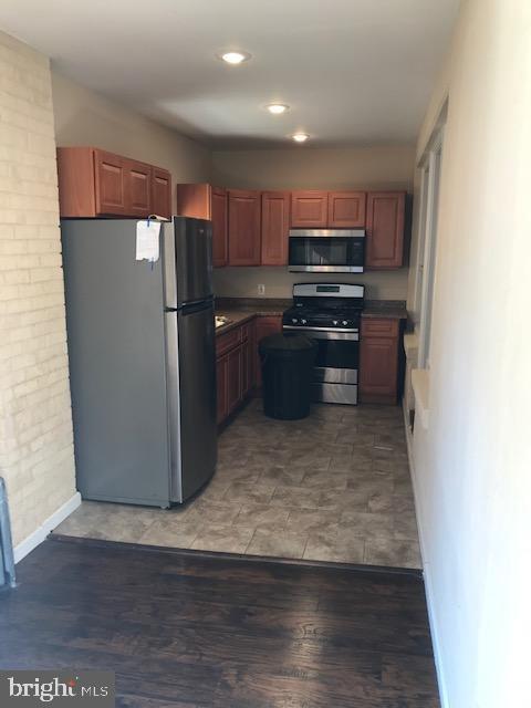
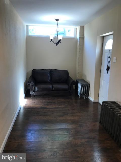
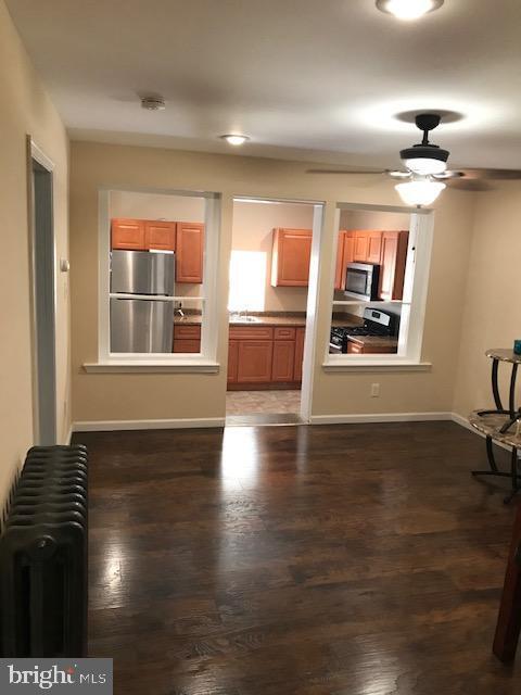
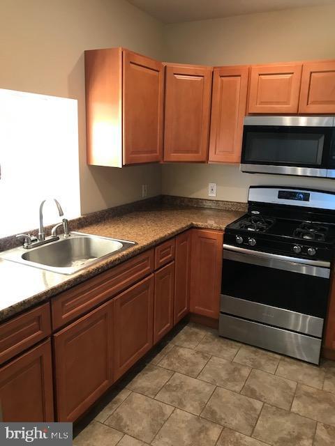
- Wood Flooring
- Mediterranean Architecture
- Stainless Steel Appliances
- Living Room
- Dining Room
- Hot Water Heating System
2011 Stenton Ave Unit A

Favorites
About This Home
Available Now
2BR apartment - Welcome home to this 1st floor unit. Enter this unit through your very own private entry. Hardwood floors throughout, open kitchen with beautiful widow view just waiting for your new kitchen set. Oak cabinets, and all stainless steel appliances. The living room area is spacious and ready to be decorated with your personal touch. Two nice size bedroom and ample closet space. The 3 piece bathroom offers a tub/shower with plenty of room. This unit leads out to the rear yard just great for winter BBQ's or a fire pit. Nearby Cheltenham & Cedarbrook Malls, Walmart, Ross & KG. Acme, Shoprite and Fresh Grocer. SEPTA transportation is just steps away.
2011 Stenton Ave is an apartment community located in Philadelphia County and the 19138 ZIP Code.
* Price shown is base rent. Excludes user-selected optional fees and variable or usage-based fees and required charges due at or prior to move-in or at move-out. Price, availability, fees, and any applicable rent special are subject to change without notice.
* Square footage definitions vary. Displayed square footage is approximate.
Home Details
Home Type
Condominium
Year Built
Built in 1915
Bedrooms and Bathrooms
2 Main Level Bedrooms
1 Full Bathroom
Home Design
Mediterranean Architecture
Brick Exterior Construction
Masonry
Entry on the 1st floor
Interior Spaces
Wood Flooring
Living Room
Dining Room
2,132 Sq Ft Home
Property has 2 Levels
Kitchen
Stainless Steel Appliances
Stove
Self-Cleaning Oven
Range Hood
Listing and Financial Details
Security Deposit $1,200
$1,200 Move-In Fee
Requires 2 Months of Rent Paid Up Front
12-Month Min and 24-Month Max Lease Term
Available 11/6/25
$50 Application Fee
Assessor Parcel Number 102335600
Tenant pays for cable TV, common area maintenance, cooking fuel, electricity, gas, heat, hot water, insurance, light bulbs/filters/fuses/alarm care, sewer, snow removal, trash removal, all utilities
The owner pays for sewer, real estate taxes, water, lawn/shrub care
Rent includes water, taxes, pest control
$200 Repair Deductible
Residential Lease
Lot Details
3,893 Sq Ft Lot
Property is in very good condition
1 Common Wall
Lot Dimensions are 51.70 x 75.30
Parking
On-Street Parking
Off-Street Parking
Schools
Edmunds Henry Elementary School
Amy Northwest Middle School
Central High School
Utilities
Hot Water Heating System
Community Details
Overview
3 Units
No Home Owners Association
Low-Rise Condominium
Property Manager
West Oak Lane Subdivision
Pet Policy
No Pets Allowed
Contact
- Listed by Robert O Merritt | Gold Keys Real Estate Specialists
- Phone Number
- Contact
-
Source
 Bright MLS, Inc.
Copyright © 2025 Bright MLS, Inc.
Location
Get Directions
Philadelphia’s West Oak Lane community is a vibrant and historic neighborhood on the north end of the city. Vintage townhomes line many of the neighborhood’s streets, but the local rental market features a diverse selection of apartments, condos, and single-family homes as well. Most of the neighborhood is residential, with a few cafes and small storefront businesses scattered throughout: low-key favorites like June’s Restaurant and Moonlight Cuisine keep the locals well-fed, day and night.
Just up Ogontz Avenue, you’ll find a much larger shopping district anchored by Cheltenham Mall as well as a diverse selection of dining options ranging from seafood to barbecue. Several public schools are positioned within walking distance of West Oak Lane, and both La Salle University and Gratz College are conveniently located nearby, making this neighborhood a great option for students, faculty, and staff members.
Learn more about living in West Oak Lane
Education
| Colleges & Universities | Distance | ||
|---|---|---|---|
| Colleges & Universities | Distance | ||
| Walk: | 15 min | 0.8 mi | |
| Drive: | 4 min | 1.3 mi | |
| Drive: | 9 min | 3.2 mi | |
| Drive: | 7 min | 3.7 mi |
2011 Stenton Ave Unit A is within 15 minutes or 0.8 mile from C.C. of Philadelphia, NW Ctr. It is also near La Salle University and Drexel Univ., Queen Lane.
Transportation options available in Philadelphia include Olney, located 1.1 miles from 2011 Stenton Ave Unit A. 2011 Stenton Ave Unit A is near Philadelphia International, located 18.8 miles or 34 minutes away, and Trenton Mercer, located 28.6 miles or 47 minutes away.
| Transit / Subway | Distance | ||
|---|---|---|---|
| Transit / Subway | Distance | ||
|
|
Drive: | 2 min | 1.1 mi |
|
|
Drive: | 3 min | 1.4 mi |
|
|
Drive: | 4 min | 1.8 mi |
|
|
Drive: | 4 min | 2.3 mi |
|
|
Drive: | 5 min | 2.7 mi |
| Commuter Rail | Distance | ||
|---|---|---|---|
| Commuter Rail | Distance | ||
|
|
Drive: | 3 min | 1.6 mi |
|
|
Drive: | 4 min | 1.7 mi |
|
|
Drive: | 5 min | 1.7 mi |
|
|
Drive: | 4 min | 2.1 mi |
|
|
Drive: | 5 min | 2.1 mi |
| Airports | Distance | ||
|---|---|---|---|
| Airports | Distance | ||
|
Philadelphia International
|
Drive: | 34 min | 18.8 mi |
|
Trenton Mercer
|
Drive: | 47 min | 28.6 mi |
Time and distance from 2011 Stenton Ave Unit A.
| Shopping Centers | Distance | ||
|---|---|---|---|
| Shopping Centers | Distance | ||
| Walk: | 14 min | 0.8 mi | |
| Walk: | 16 min | 0.8 mi | |
| Walk: | 17 min | 0.9 mi |
2011 Stenton Ave Unit A has 3 shopping centers within 0.9 mile, which is about a 17-minute walk. The miles and minutes will be for the farthest away property.
| Parks and Recreation | Distance | ||
|---|---|---|---|
| Parks and Recreation | Distance | ||
|
Awbury Arboretum
|
Drive: | 3 min | 1.4 mi |
|
Tacony Creek Park
|
Drive: | 8 min | 4.5 mi |
|
The Morris Arboretum
|
Drive: | 12 min | 5.2 mi |
|
Wissahickon Environmental Center
|
Drive: | 11 min | 5.5 mi |
|
Schuylkill Center for Environmental Education
|
Drive: | 18 min | 7.7 mi |
2011 Stenton Ave Unit A has 5 parks within 7.7 miles, including Awbury Arboretum, Tacony Creek Park, and The Morris Arboretum.
| Hospitals | Distance | ||
|---|---|---|---|
| Hospitals | Distance | ||
| Drive: | 3 min | 1.3 mi | |
| Drive: | 7 min | 3.4 mi | |
| Drive: | 8 min | 3.6 mi |
2011 Stenton Ave Unit A has 3 hospitals within 3.6 miles, the nearest is Albert Einstein Medical Center which is 1.3 miles away and a 3 minute drive.
| Military Bases | Distance | ||
|---|---|---|---|
| Military Bases | Distance | ||
| Drive: | 26 min | 12.6 mi |
2011 Stenton Ave Unit A is 12.6 miles and a 26 minute drive from Willow Grove Naval Air Station.
You May Also Like
Similar Rentals Nearby


What Are Walk Score®, Transit Score®, and Bike Score® Ratings?
Walk Score® measures the walkability of any address. Transit Score® measures access to public transit. Bike Score® measures the bikeability of any address.
What is a Sound Score Rating?
A Sound Score Rating aggregates noise caused by vehicle traffic, airplane traffic and local sources

2011 Stenton Ave
Philadelphia, PA 19138