$1,995 / Month
2 Deering Ct Unit 2
Oakland, CA 94601
2 Weeks Ago
Favorites
2 Deering Ct Unit 2

Favorites
Check Back Soon for Upcoming Availability
| Beds | Baths | Average SF |
|---|---|---|
| 2 Bedrooms 2 Bedrooms 2 Br | 1 Bath 1 Bath 1 Ba | 775 SF |
Fees and Policies
The fees below are based on community-supplied data and may exclude additional fees and utilities.
- Dogs Allowed
-
Fees not specified
- Cats Allowed
-
Fees not specified
About This Property
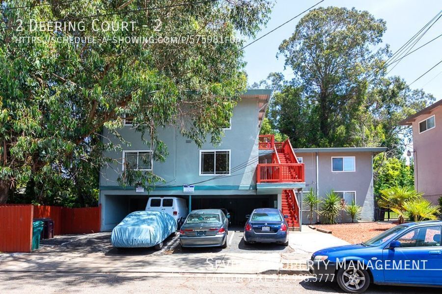
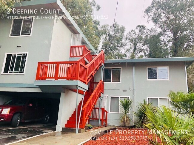
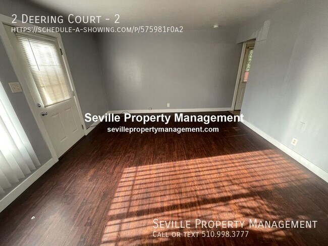
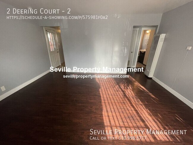
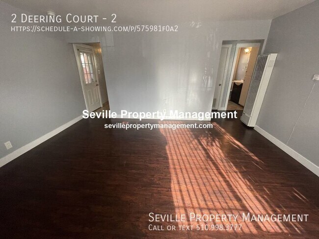
---- SCHEDULE A SHOWING ONLINE AT: ---- REDUCED $1995/mo Freshly painted 1st floor, 2 bedrooms/1 bathroom Apartment Located in 4 unit building near Coolidge & 580 Fwy. Unit has newer kitchen and bathroom updates. In-Unit Washer/Dryer hookups. 2-Car tandem parking, Assigned Storage, Large shared backyard. Lease Length: 12-18 months Income Requirement: Must be at least 2.5x rent in total household gross income (before taxes) Application Fee: $45 per applicant/occupant over 18 years old $1995 Rent + Deposit: $1995* (may be higher - review Rental Criteria before applying) Renter responsible for PGE & EBMUD, and must carry Renter's Insurance Owner responsible for yard & garbage *PROPERTY MANAGER: Seville Property Management Move-In Ready, 1st floor unit previously updated and has been freshly painted thru-out. Laminate flooring in kitchen, bedroom, and living room. Located in a 4-unit building with off-street 1-car tandem parking, and in unit laundry. Conveniently located with easy access to freeways, shopping, and public transportation. Come see today! *All information is deemed reliable but not guaranteed and is subject to change.* 2 Car Off Street Parking Garbage Shared Backyard
2 Deering Ct is an apartment community located in Alameda County and the 94601 ZIP Code.
Location
Get Directions
Upper Peralta Creek is a residential neighborhood comprised of colorful California bungalows, churches, and markets. Curtis Flood Field and Nicol Park rest just outside of Upper Peralta Creek. Farther down the Peralta Creek, the nearby Peralta Hacienda Historical Park pays homage to Native and Mexican American culture and history.
Peralta Creek and multiple bus routes are accessible from Upper Peralta Creek. About five miles from Downtown Oakland and all of its amenities, commuting from Upper Peralta Creek is simple with convenient access to I-580. Oakland International Airport is a mere eight miles south of the neighborhood, allowing for easy travels.
Learn more about living in Upper Peralta CreekBelow are rent ranges for similar nearby apartments
Education
| Colleges & Universities | Distance | ||
|---|---|---|---|
| Colleges & Universities | Distance | ||
| Drive: | 8 min | 2.7 mi | |
| Drive: | 7 min | 3.3 mi | |
| Drive: | 9 min | 4.1 mi | |
| Drive: | 9 min | 4.4 mi |
2 Deering Ct Unit 2 is within 8 minutes or 2.7 miles from Mills College. It is also near Laney College and Lincoln University, Oakland.
Transportation options available in Oakland include Fruitvale Station, located 1.5 miles from 2 Deering Ct Unit 2. 2 Deering Ct Unit 2 is near Metro Oakland International, located 7.3 miles or 13 minutes away, and San Francisco International, located 26.0 miles or 39 minutes away.
| Transit / Subway | Distance | ||
|---|---|---|---|
| Transit / Subway | Distance | ||
|
|
Drive: | 3 min | 1.5 mi |
|
|
Drive: | 8 min | 3.7 mi |
|
|
Drive: | 8 min | 3.8 mi |
|
|
Drive: | 8 min | 4.1 mi |
|
|
Drive: | 9 min | 4.5 mi |
| Commuter Rail | Distance | ||
|---|---|---|---|
| Commuter Rail | Distance | ||
|
|
Drive: | 9 min | 4.6 mi |
|
|
Drive: | 11 min | 7.0 mi |
|
|
Drive: | 14 min | 9.1 mi |
| Drive: | 21 min | 13.6 mi | |
| Drive: | 22 min | 14.8 mi |
| Airports | Distance | ||
|---|---|---|---|
| Airports | Distance | ||
|
Metro Oakland International
|
Drive: | 13 min | 7.3 mi |
|
San Francisco International
|
Drive: | 39 min | 26.0 mi |
Time and distance from 2 Deering Ct Unit 2.
| Shopping Centers | Distance | ||
|---|---|---|---|
| Shopping Centers | Distance | ||
| Walk: | 20 min | 1.1 mi | |
| Drive: | 3 min | 1.5 mi | |
| Drive: | 3 min | 1.5 mi |
2 Deering Ct Unit 2 has 3 shopping centers within 1.5 miles, which is about a 3-minute walk. The miles and minutes will be for the farthest away property.
| Parks and Recreation | Distance | ||
|---|---|---|---|
| Parks and Recreation | Distance | ||
|
Lakeside Park
|
Drive: | 6 min | 3.4 mi |
|
Rotary Nature Center
|
Drive: | 7 min | 3.7 mi |
|
Roberts Regional Recreation Area
|
Drive: | 11 min | 4.5 mi |
|
Chabot Space & Science Center
|
Drive: | 13 min | 5.1 mi |
|
Joaquin Miller Park
|
Drive: | 13 min | 5.2 mi |
2 Deering Ct Unit 2 has 5 parks within 5.2 miles, including Lakeside Park, Joaquin Miller Park, and Rotary Nature Center.
| Hospitals | Distance | ||
|---|---|---|---|
| Hospitals | Distance | ||
| Walk: | 11 min | 0.6 mi | |
| Drive: | 5 min | 1.8 mi | |
| Drive: | 9 min | 3.6 mi |
2 Deering Ct Unit 2 has 3 hospitals within 3.6 miles, the nearest is Telecare Heritage Psychiatric Health Facility which is 0.6 mile away and a 11 minute walk.
| Military Bases | Distance | ||
|---|---|---|---|
| Military Bases | Distance | ||
| Drive: | 17 min | 7.2 mi | |
| Drive: | 17 min | 8.2 mi |
2 Deering Ct Unit 2 is 7.2 miles from Alameda/US Naval Air Station Alameda, and is convenient to other military bases, including Oakland Army Base.
You May Also Like
Similar Rentals Nearby


What Are Walk Score®, Transit Score®, and Bike Score® Ratings?
Walk Score® measures the walkability of any address. Transit Score® measures access to public transit. Bike Score® measures the bikeability of any address.
What is a Sound Score Rating?
A Sound Score Rating aggregates noise caused by vehicle traffic, airplane traffic and local sources

2 Deering Ct
Oakland, CA 94601