
$3,870
/ Month
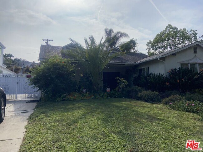
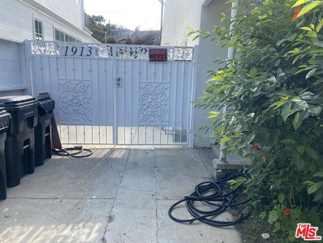
1913 Hillsboro Ave
Los Angeles, CA 90035
2 Weeks Ago
|
Edit
Favorites
1913 Hillsboro Ave

Favorites
Check Back Soon for Upcoming Availability
| Beds | Baths | Average SF |
|---|---|---|
| 2 Bedrooms 2 Bedrooms 2 Br | 2 Baths 2 Baths 2 Ba | 1,000 SF |
About This Property
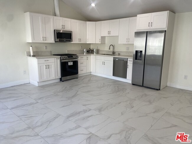
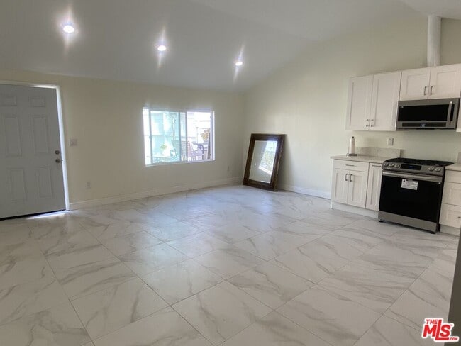
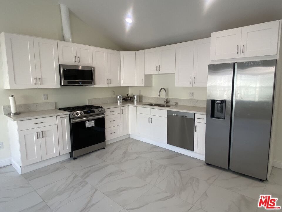
Brand New ADU / Guesthouse in prime Beverlywood. This 2 bedroom 2 bathroom back house has beautiful marble tile throughout. High ceilings. Central air conditioning AC and heat. Kitchen with quartz countertops, stainless steel brand new stove, dishwasher, refrigerator and microwave. Washer/dryer, laundry included. Recessed lighting. Street parking is very easy in this residential neighborhood. Shared outdoor patio. Close to 10 freeway, 405 freeway, Beverly Hills, Cheviot Hills, Pico Blvd, west of Robertson Blvd
1913 Hillsboro Ave is an apartment community located in Los Angeles County and the 90035 ZIP Code.
Features
Washer/Dryer
Air Conditioning
Dishwasher
Washer/Dryer Hookup
- Washer/Dryer
- Washer/Dryer Hookup
- Air Conditioning
- Dishwasher
- Disposal
- Microwave
- Refrigerator
Location
Get Directions
Beverlywood is a welcoming neighborhood located directly south of Beverly Hills in Los Angeles. The community feels very homey, with many residents having lived in the area for years or even decades. Much of Beverlywood is an incorporated community, so residents enjoy access to private parks and a high standard of living. Well-maintained streets, picturesque landscaping, and charming homes define this neighborhood. Residents enjoy proximity to the Hillcrest Country Club, the Rancho Park Golf Club, the Museum of Jurassic Technology, and Rodeo Drive. Those renting upscale apartments in Beverlywood have easy access to the entire west side of Los Angeles, with its great shopping, dining, and entertainment options.
Learn more about living in BeverlywoodBelow are rent ranges for similar nearby apartments
Amenities
- Washer/Dryer
- Washer/Dryer Hookup
- Air Conditioning
- Dishwasher
- Disposal
- Microwave
- Refrigerator
Education
| Colleges & Universities | Distance | ||
|---|---|---|---|
| Colleges & Universities | Distance | ||
| Drive: | 10 min | 3.7 mi | |
| Drive: | 12 min | 5.2 mi | |
| Drive: | 11 min | 5.8 mi | |
| Drive: | 10 min | 5.9 mi |
1913 Hillsboro Ave is within 10 minutes or 3.7 miles from West Los Angeles College. It is also near Santa Monica Coll., Bundy and UCLA.
Transportation options available in Los Angeles include Culver City, located 1.5 miles from 1913 Hillsboro Ave. 1913 Hillsboro Ave is near Los Angeles International, located 8.9 miles or 18 minutes away, and Bob Hope, located 15.4 miles or 29 minutes away.
| Transit / Subway | Distance | ||
|---|---|---|---|
| Transit / Subway | Distance | ||
|
|
Drive: | 4 min | 1.5 mi |
|
|
Drive: | 5 min | 2.0 mi |
|
|
Drive: | 4 min | 2.0 mi |
|
|
Drive: | 7 min | 3.6 mi |
|
|
Drive: | 7 min | 3.6 mi |
| Commuter Rail | Distance | ||
|---|---|---|---|
| Commuter Rail | Distance | ||
|
|
Drive: | 17 min | 10.6 mi |
|
|
Drive: | 19 min | 10.7 mi |
|
|
Drive: | 23 min | 12.7 mi |
|
|
Drive: | 26 min | 13.3 mi |
|
|
Drive: | 28 min | 14.2 mi |
| Airports | Distance | ||
|---|---|---|---|
| Airports | Distance | ||
|
Los Angeles International
|
Drive: | 18 min | 8.9 mi |
|
Bob Hope
|
Drive: | 29 min | 15.4 mi |
Time and distance from 1913 Hillsboro Ave.
| Shopping Centers | Distance | ||
|---|---|---|---|
| Shopping Centers | Distance | ||
| Walk: | 7 min | 0.4 mi | |
| Walk: | 13 min | 0.7 mi | |
| Walk: | 13 min | 0.7 mi |
1913 Hillsboro Ave has 3 shopping centers within 0.7 mile, which is about a 13-minute walk. The miles and minutes will be for the farthest away property.
| Parks and Recreation | Distance | ||
|---|---|---|---|
| Parks and Recreation | Distance | ||
|
Zimmer Children's Museum
|
Drive: | 6 min | 2.8 mi |
|
La Brea Tar Pits
|
Drive: | 7 min | 3.2 mi |
|
Virginia Robinson Gardens
|
Drive: | 9 min | 3.6 mi |
|
Kenneth Hahn State Recreation Area
|
Drive: | 11 min | 4.1 mi |
|
Mathias Botanical Garden
|
Drive: | 11 min | 4.8 mi |
1913 Hillsboro Ave has 5 parks within 4.8 miles, including Zimmer Children's Museum, La Brea Tar Pits, and Virginia Robinson Gardens.
| Hospitals | Distance | ||
|---|---|---|---|
| Hospitals | Distance | ||
| Walk: | 20 min | 1.1 mi | |
| Drive: | 6 min | 2.6 mi | |
| Drive: | 5 min | 2.6 mi |
1913 Hillsboro Ave has 3 hospitals within 2.6 miles, the nearest is Kaiser Foundation Hospital - West LA which is 1.1 miles away and a 20 minute walk.
| Military Bases | Distance | ||
|---|---|---|---|
| Military Bases | Distance | ||
| Drive: | 18 min | 10.7 mi |
1913 Hillsboro Ave is 10.7 miles and a 18 minute drive from Los Angeles Air Force Base.
You May Also Like
Similar Rentals Nearby


What Are Walk Score®, Transit Score®, and Bike Score® Ratings?
Walk Score® measures the walkability of any address. Transit Score® measures access to public transit. Bike Score® measures the bikeability of any address.
What is a Sound Score Rating?
A Sound Score Rating aggregates noise caused by vehicle traffic, airplane traffic and local sources
1913 Hillsboro Ave
Los Angeles, CA 90035