
Presidential Towers
555 W Madison St,
Chicago, IL 60661
$1,760 - $9,575
Studio - 2 Beds
Bedrooms
1 bd
Bathrooms
1 ba
Square Feet
750 sq ft
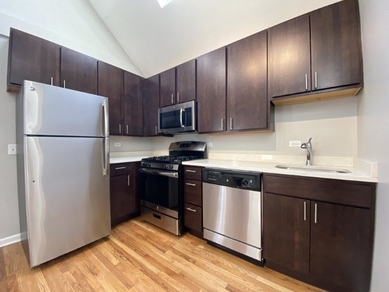
Enjoy all the comforts you crave-and everything that buzzes in Bucktown-at 1835 N. Paulina. Located on a quiet tree-lined street, 1835 N. Paulina is a pet-friendly building that features large, updated baths and kitchens with stainless steel appliances, granite countertops and dishwashers, spacious closets, in-home laundry and hardwood floors throughout. Home to more artists than any other area in the Midwest, the Bucktown/Wicker Park neighborhood is known for its thriving community of cafes, restaurants and nightlife. 1835 N. Paulina is steps from Damen Avenue shopping and entertainment, right off the Kennedy Expressway, a 4-minute walk to the Clybourn Metra and a 10-minute walk to Mariano's.
1835 N Paulina is an apartment community located in Cook County and the 60622 ZIP Code. This area is served by the Chicago Public Schools attendance zone.
Dishwasher
Hardwood Floors
Microwave
Refrigerator
Bucktown is one of Chicago’s trendiest neighborhoods, and it’s more affordable than nearby neighborhoods. It’s just a few miles northwest of downtown Chicago and is bordered by the Chicago River on the east. Kennedy Expressway (I-94) runs right through the neighborhood, giving residents easy access to the Chicago area and beyond. Public transportation is extensive, and the neighborhood is walkable and filled with shopping, dining, and artsy entertainment. There’s a great selection of live music, art exhibits, live theater, and themed bars. A ton of restaurants offer a variety of food from different cultures.
If you’re looking for family fun in Bucktown, there are plenty of public parks available for the community, such as Holstein Park, Churchill Park, and Ehrler Park. Amenities include open green space, swimming pools, ball fields, and more.
Learn more about living in Bucktown| Colleges & Universities | Distance | ||
|---|---|---|---|
| Colleges & Universities | Distance | ||
| Drive: | 3 min | 1.6 mi | |
| Drive: | 5 min | 2.3 mi | |
| Drive: | 6 min | 2.6 mi | |
| Drive: | 5 min | 2.7 mi |


Transportation options available in Chicago include Damen Station (Blue Line), located 0.8 mile from 1835 N Paulina. 1835 N Paulina is near Chicago Midway International, located 11.7 miles or 21 minutes away, and Chicago O'Hare International, located 14.5 miles or 22 minutes away.
| Transit / Subway | Distance | ||
|---|---|---|---|
| Transit / Subway | Distance | ||
|
|
Walk: | 14 min | 0.8 mi |
|
|
Walk: | 16 min | 0.9 mi |
|
|
Walk: | 19 min | 1.0 mi |
|
|
Drive: | 2 min | 1.4 mi |
|
|
Drive: | 3 min | 1.4 mi |
| Commuter Rail | Distance | ||
|---|---|---|---|
| Commuter Rail | Distance | ||
|
|
Walk: | 4 min | 0.2 mi |
|
|
Drive: | 6 min | 2.8 mi |
|
|
Drive: | 6 min | 3.1 mi |
|
|
Drive: | 7 min | 3.4 mi |
|
|
Drive: | 7 min | 3.7 mi |
| Airports | Distance | ||
|---|---|---|---|
| Airports | Distance | ||
|
Chicago Midway International
|
Drive: | 21 min | 11.7 mi |
|
Chicago O'Hare International
|
Drive: | 22 min | 14.5 mi |
Time and distance from 1835 N Paulina.
| Shopping Centers | Distance | ||
|---|---|---|---|
| Shopping Centers | Distance | ||
| Walk: | 6 min | 0.3 mi | |
| Walk: | 15 min | 0.8 mi | |
| Walk: | 15 min | 0.8 mi |
| Parks and Recreation | Distance | ||
|---|---|---|---|
| Parks and Recreation | Distance | ||
|
Wrightwood Park
|
Drive: | 3 min | 1.1 mi |
|
Oz Park
|
Drive: | 4 min | 2.0 mi |
|
Humboldt Park
|
Drive: | 4 min | 2.3 mi |
|
Lincoln Park Zoo
|
Drive: | 5 min | 2.8 mi |
|
Lincoln Park
|
Drive: | 5 min | 2.8 mi |
| Hospitals | Distance | ||
|---|---|---|---|
| Hospitals | Distance | ||
| Drive: | 3 min | 1.5 mi | |
| Drive: | 6 min | 2.4 mi | |
| Drive: | 5 min | 2.5 mi |
| Military Bases | Distance | ||
|---|---|---|---|
| Military Bases | Distance | ||
| Drive: | 31 min | 22.1 mi |
What Are Walk Score®, Transit Score®, and Bike Score® Ratings?
Walk Score® measures the walkability of any address. Transit Score® measures access to public transit. Bike Score® measures the bikeability of any address.
What is a Sound Score Rating?
A Sound Score Rating aggregates noise caused by vehicle traffic, airplane traffic and local sources

1835 N Paulina St
Chicago, IL 60622


