$2,400
/ Month
16655 Gazeley St Unit B
Canyon Country, CA 91351
Favorites
661-250-6822
-
Bedrooms
2
-
Bathrooms
1
-
Square Feet
700 sq ft
-
Available
Available Now
16655 Gazeley St Unit B

Favorites
About This Home
Available Now
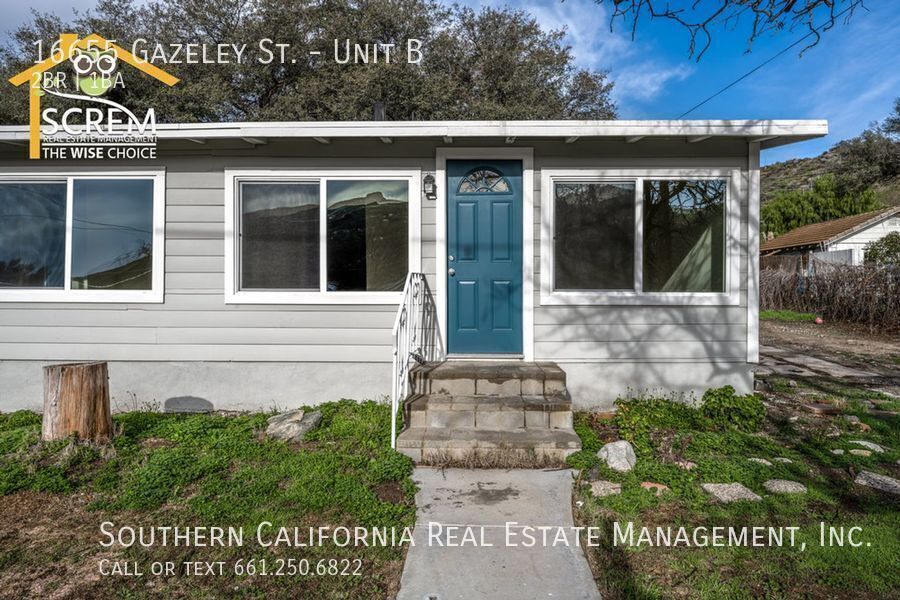
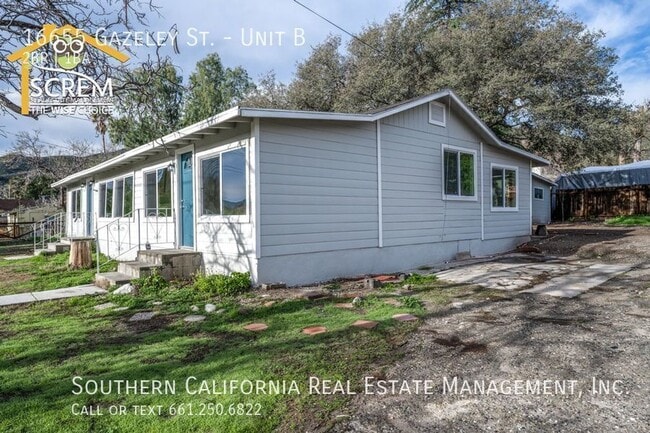
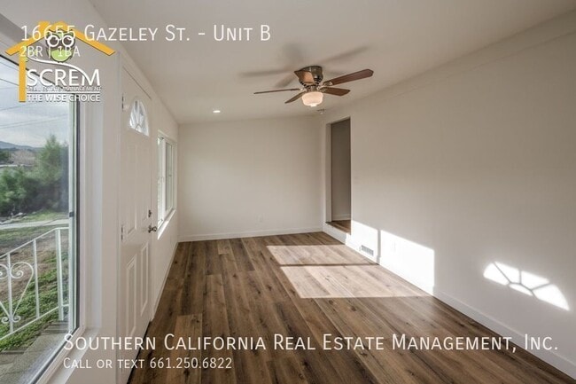
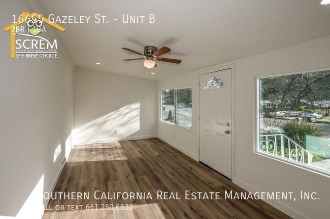
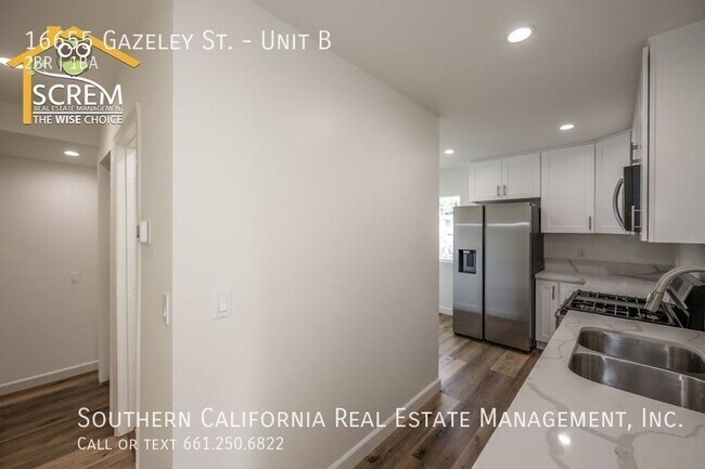
This updated duplex features two bedrooms and one bathroom, located in Canyon Country. Upon entering, you will be greeted by a bright living room with a ceiling fan and ample windows that let natural light fill the space. Adjacent to the living room is a beautifully updated kitchen with quartz countertops, white cabinets with brushed-silver hardware, recessed lighting, and a dining area. The kitchen is furnished with essential stainless steel appliances, including a gas stove, single oven, microwave, dishwasher, and refrigerator. Both bedrooms feature ceiling fans and mirrored closet doors. The bathroom has been tastefully renovated with a walk-in shower, a stylish vanity, and decorative tile flooring. For added convenience, a stackable washer and dryer is located in the hallway closet, and luxury vinyl plank flooring runs throughout the unit. You can also enjoy a spacious backyard, a storage shed, and stunning mountain views. The rent includes electricity, water, trash, and gas. *Owner may consider a small pet. For inquiries about this property, please email . To schedule a viewing appointment, visit
16655 Gazeley St is an apartment community located in Los Angeles County and the 91351 ZIP Code.
* Price shown is base rent. Excludes user-selected optional fees and variable or usage-based fees and required charges due at or prior to move-in or at move-out. Price, availability, fees, and any applicable rent special are subject to change without notice.
* Square footage definitions vary. Displayed square footage is approximate.
Contact
- Listed by Laurie | Southern California Real Estate Management, Inc.
- Phone Number
- Contact
Location
Get Directions
Situated in Southern California, Santa Clarita Valley is an opulent suburb surrounded by nature preserves. The northern section of the region encompasses Castaic Lake State Recreation Park, while the eastern and western sides of the area are bordered by the Santa Clarita Woodlands Park and the Golden Valley Ranch Open Space. Also located in the valley are meandering trails that follow along the river and connect to scenic community parks. Located just 35 miles north of Los Angeles, Santa Clarita offers more than the great outdoors. Places like Six Flags Magic Mountain, sprawling golf courses, and premier shopping at plazas like Westfield Valencia Town Center are all located within Santa Clarita Valley. More shopping and retail centers can be found off Lyons Avenue and Soledad Canyon Road, while Main Street’s locally owned cafes, specialty shops, and restaurants provide a nice contrast to large commercial plazas.
Learn more about living in Santa Clarita Valley
Education
| Colleges & Universities | Distance | ||
|---|---|---|---|
| Colleges & Universities | Distance | ||
| Drive: | 21 min | 11.1 mi | |
| Drive: | 23 min | 17.5 mi | |
| Drive: | 30 min | 18.8 mi | |
| Drive: | 32 min | 24.8 mi |
16655 Gazeley St Unit B is within 21 minutes or 11.1 miles from College of the Canyons. It is also near Mission College and Cal State Northridge.
Getting Around
 What do Walkability, Transit, Drivability, and Bikeability mean?
Walkability measures the walking distance to day-to-day needs.
Transit measures access to public transportation.
Drivability measures congestion, parking availability, and access to major roads.
Bikeability measures the suitability for cycling.
How It Works
What do Walkability, Transit, Drivability, and Bikeability mean?
Walkability measures the walking distance to day-to-day needs.
Transit measures access to public transportation.
Drivability measures congestion, parking availability, and access to major roads.
Bikeability measures the suitability for cycling.
How It Works
Somewhat Walkable
Walkability
20
/ 100
Limited Public Transit
Transit
30
/ 100
Exceptionally Drivable
Drivability
100
/ 100
Somewhat Bikeable
Bikeability
30
/ 100
Scores provided by
Active
Soundscore™
78
/ 100
Traffic
ActiveAirport
CalmBusinesses
CalmScores provided by
HowLoud What is a Sound Score Rating? A Sound Score Rating aggregates noise caused by vehicle traffic, airplane traffic and local sources. How It WorksYou May Also Like
Similar Rentals Nearby
-
-
-
-
-
-
2 Beds$3,644+Total Monthly PriceTotal Monthly Price NewPrices include base rent and required monthly fees of $11. Variable costs based on usage may apply.Base Rent:2 Beds$3,632+Specials
Pets Allowed Pool
-
-
-
2 Beds$2,992+3 Beds$3,524Total Monthly PriceTotal Monthly Price NewPrices include base rent and required monthly fees. Variable costs based on usage may apply.Specials
Pets Allowed Fitness Center Pool Dishwasher Refrigerator Kitchen
-
2 Beds$3,114+3 Beds$3,814+Total Monthly Price12 Month LeaseTotal Monthly Price NewPrices include base rent and required monthly fees of $8. Variable costs based on usage may apply.Base Rent:2 Beds$3,005+3 Beds$3,805+Specials
Pets Allowed Fitness Center Pool Dishwasher Refrigerator In Unit Washer & Dryer


16655 Gazeley St
Canyon Country, CA 91351