
$3,000 / Month
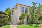
1660 Manning Ave
Los Angeles, CA 90024
Today
Favorites
310-579-2200
-
Bedrooms
1
-
Bathrooms
1
-
Square Feet
--
-
Available
Available Now
Highlights
- Hardwood Floors
- Den
1660 Manning Ave

Favorites
About This Home
$3,250 deposit,
Available Now
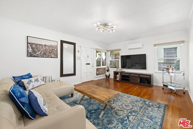
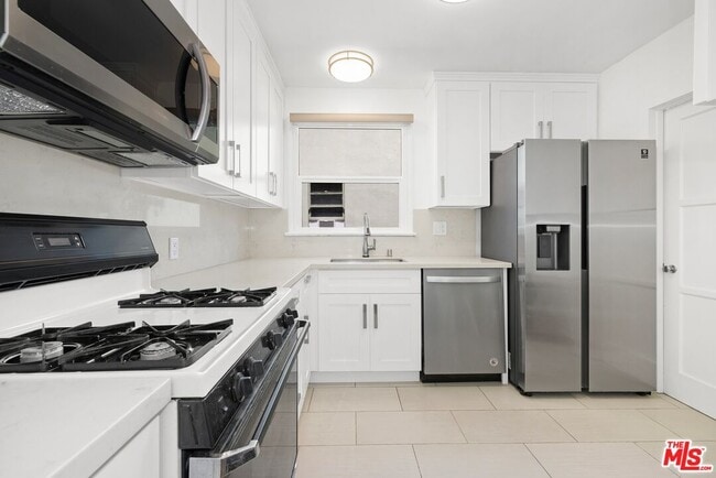
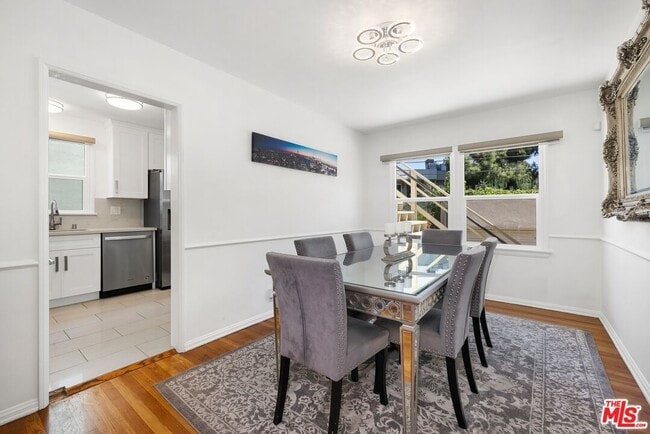
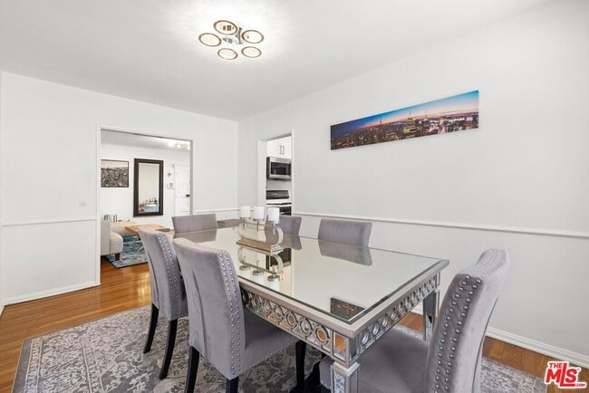
Presenting a well-maintained and updated unit in a desirable fourplex with a large grassy front lawn. Set back from the street at the rear of the building, this first-floor home is full of charm with gleaming hardwood floors, a remodeled kitchen with bright white cabinetry and stainless-steel appliances, and light-filled dining room. The spacious bedroom is adjacent to a bathroom with separate tub and glass-enclosed shower. Washer/dryer in unit. Welcome to your new lifestyle in a central location just moments to Westwood Village, Century City, Beverly Hills, freeways, and the numerous offerings of the Westside. MLS# 25518615
1660 Manning Ave is a condo located in Los Angeles County and the 90024 ZIP Code.
* Price shown is base rent and may not include non-optional fees and utilities.
Price, availability, fees, and any applicable rent special are subject to change without notice.
* Square footage definitions vary. Displayed square footage is approximate.
Condo Features
Washer/Dryer
Dishwasher
Hardwood Floors
Refrigerator
- Washer/Dryer
- Dishwasher
- Refrigerator
- Hardwood Floors
- Den
- Views
Fees and Policies
The fees below are based on community-supplied data and may exclude additional fees and utilities.
Contact
- Listed by Sally Forster Jones | Compass
- Phone Number
- Contact
-
Source
 MLS(TM)/CLAW
Copyright 2025 TheMLS/CLAW. All rights reserved. Information is deemed reliable but not guaranteed.
Location
Get Directions
Amenities
- Washer/Dryer
- Dishwasher
- Refrigerator
- Hardwood Floors
- Den
- Views
Home to UCLA, Westwood lies on the west side of the city and is considered to be one of Los Angeles’ premier neighborhoods. Bordered by Beverly Hills, Bel Air, Brentwood, and Century City, multimillion dollar homes populate the landscape and students pay a premium to rent near campus.
The university itself serves as a major cultural center for the community, including on-campus attractions (such as the Fowler Museum and the Franklin D. Murphy Sculpture Garden) and university-affiliated venues off-campus (The Hammer Museum, the Geffen Playhouse), as well as the presence of thousands of students and faculty members throughout the neighborhood.
Directly south of campus, Westwood Village is a historic shopping district that features blocks of restaurants and businesses catering to both students and the neighborhood’s larger workforce. Many prominent corporations and law offices are found along Wilshire Boulevard, one of the busiest east-west transit corridors across the city.
Learn more about living in Westwood
Education
| Colleges & Universities | Distance | ||
|---|---|---|---|
| Colleges & Universities | Distance | ||
| Drive: | 5 min | 1.6 mi | |
| Drive: | 8 min | 3.1 mi | |
| Drive: | 9 min | 3.8 mi | |
| Drive: | 9 min | 3.8 mi |
1660 Manning Ave is within 5 minutes or 1.6 miles from UCLA. It is also near Santa Monica Coll., Academy and The Art Inst., Los Angeles.
Transportation options available in Los Angeles include Westwood / Rancho Park Station, located 1.7 miles from 1660 Manning Ave. 1660 Manning Ave is near Los Angeles International, located 10.2 miles or 17 minutes away, and Bob Hope, located 18.7 miles or 28 minutes away.
| Transit / Subway | Distance | ||
|---|---|---|---|
| Transit / Subway | Distance | ||
| Drive: | 4 min | 1.7 mi | |
| Drive: | 4 min | 1.8 mi | |
| Drive: | 6 min | 2.6 mi | |
| Drive: | 7 min | 2.7 mi | |
| Drive: | 8 min | 4.6 mi |
| Commuter Rail | Distance | ||
|---|---|---|---|
| Commuter Rail | Distance | ||
| Drive: | 26 min | 13.2 mi | |
|
|
Drive: | 27 min | 13.5 mi |
|
|
Drive: | 22 min | 13.6 mi |
| Drive: | 21 min | 15.0 mi | |
| Drive: | 28 min | 18.6 mi |
| Airports | Distance | ||
|---|---|---|---|
| Airports | Distance | ||
|
Los Angeles International
|
Drive: | 17 min | 10.2 mi |
|
Bob Hope
|
Drive: | 28 min | 18.7 mi |
Time and distance from 1660 Manning Ave.
| Shopping Centers | Distance | ||
|---|---|---|---|
| Shopping Centers | Distance | ||
| Walk: | 11 min | 0.6 mi | |
| Walk: | 11 min | 0.6 mi | |
| Walk: | 14 min | 0.7 mi |
1660 Manning Ave has 3 shopping centers within 0.7 mile, which is about a 14-minute walk. The miles and minutes will be for the farthest away property.
| Parks and Recreation | Distance | ||
|---|---|---|---|
| Parks and Recreation | Distance | ||
|
Mathias Botanical Garden
|
Drive: | 4 min | 1.2 mi |
|
Hannah Carter Japanese Garden
|
Drive: | 7 min | 2.5 mi |
|
Virginia Robinson Gardens
|
Drive: | 9 min | 3.5 mi |
|
Zimmer Children's Museum
|
Drive: | 9 min | 4.3 mi |
|
Franklin Canyon Park
|
Drive: | 17 min | 5.9 mi |
1660 Manning Ave has 5 parks within 5.9 miles, including Mathias Botanical Garden, Hannah Carter Japanese Garden, and Virginia Robinson Gardens.
| Hospitals | Distance | ||
|---|---|---|---|
| Hospitals | Distance | ||
| Drive: | 5 min | 1.5 mi | |
| Drive: | 5 min | 1.6 mi | |
| Drive: | 8 min | 3.3 mi |
1660 Manning Ave has 3 hospitals within 3.3 miles, the nearest is Ronald Reagan UCLA Medical Center which is 1.5 miles away and a 5 minute drive.
| Military Bases | Distance | ||
|---|---|---|---|
| Military Bases | Distance | ||
| Drive: | 18 min | 12.8 mi |
1660 Manning Ave is 12.8 miles and a 18 minute drive from Los Angeles Air Force Base.
You May Also Like
Similar Rentals Nearby
-
-

-

-

-

-
-
-
1 / 33

-
-


What Are Walk Score®, Transit Score®, and Bike Score® Ratings?
Walk Score® measures the walkability of any address. Transit Score® measures access to public transit. Bike Score® measures the bikeability of any address.
What is a Sound Score Rating?
A Sound Score Rating aggregates noise caused by vehicle traffic, airplane traffic and local sources

1660 Manning Ave
Los Angeles, CA 90024