
$2,600 / Month
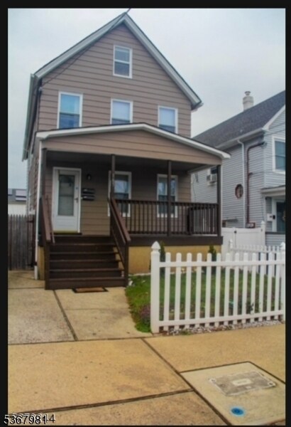
165 Emerson St
Carteret, NJ 07008
Today
Favorites
973-661-1719
-
Bedrooms
3
-
Bathrooms
1
-
Square Feet
--
-
Available
Available Now
165 Emerson St

Favorites
About This Home
Available Now
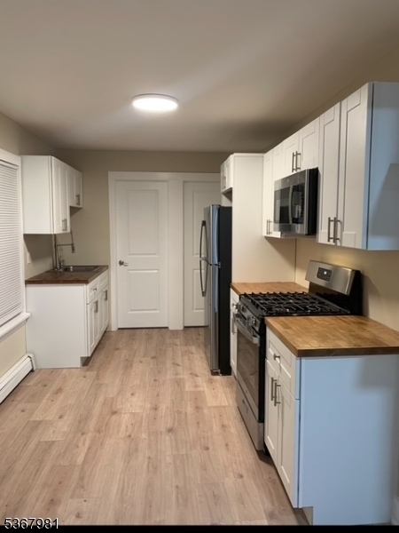
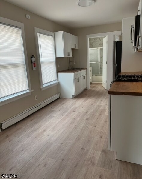
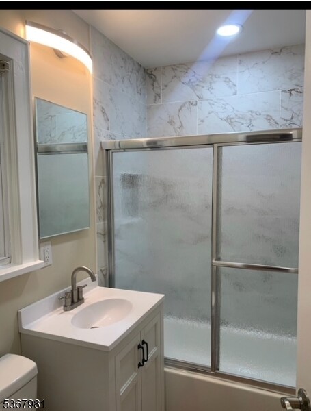
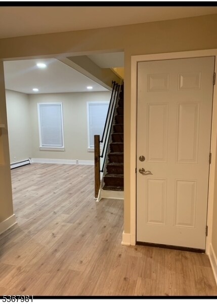
Available Now! Updated 3 Bedroom / 1 Bath, nestled on the second floor of a charming multifamily home located in a desirable location in Carteret. Close to local shops, gyms, public transportation! Location, Location, Location! Each apartment has their own washer and dryer located in the basement. They also have access to their own small storage unit. You can take advantage of the backyard space for entertaining! Apartment is available for immediate showings; however, tenant consideration is subject to the completion of necessary requirements. Prospective tenants must submit a rental application and undergo an NTN check and credit check.
165 Emerson St is a house located in Middlesex County and the 07008 ZIP Code. This area is served by the Carteret Public attendance zone.
* Price shown is base rent and may not include non-optional fees and utilities.
Price, availability, fees, and any applicable rent special are subject to change without notice.
* Square footage definitions vary. Displayed square footage is approximate.
House Features
- Air Conditioning
Fees and Policies
The fees below are based on community-supplied data and may exclude additional fees and utilities.
- Parking
-
Street--
Contact
- Listed by JASMINE PAGAN | GardenStateMLS#NJ
- Phone Number
-
Source
Garden State Multiple Listing Service, LLC
Copyright © 2025 Garden State MLS, LLC. All rights reserved. All information provided by the listing agent/broker is deemed reliable but is not guaranteed and should be independently verified.
Location
Get Directions
Amenities
- Air Conditioning
Located directly across the Arthur Kill from Staten Island, Carteret was once part of the Woodbridge Township. It became the borough of Roosevelt in 1906 and was renamed Carteret in 1922. This popular community is bordered by the Rahway River to the north, Arthur Kill to the east, and the Ernest L. Oros Wildlife Preserve to the west. Due to its central location, the borough bills itself as the "Center of it All."
Residents enjoy a fantastic location and beautiful parks. Carteret Waterfront Park has a fishing pier and access to two hiking trails: Danielle's Garden Trail and the Waterfront Fitness Trail. Shopping in Carteret is plentiful -- the brick-paved sidewalks and outdoor cafes along Washington Avenue provide historic charm and locally-owned businesses, while the shops and restaurants along Roosevelt Avenue have a more modern feel. With just 22 miles to Manhattan, 10 miles to Newark, and 70 miles to Philadelphia, residents can easily commute to nearby cities.
Learn more about living in Carteret
Education
| Colleges & Universities | Distance | ||
|---|---|---|---|
| Colleges & Universities | Distance | ||
| Drive: | 15 min | 7.4 mi | |
| Drive: | 18 min | 9.0 mi | |
| Drive: | 19 min | 10.3 mi | |
| Drive: | 24 min | 13.2 mi |
165 Emerson St is within 15 minutes or 7.4 miles from Union County Coll., Elizabeth. It is also near Kean University and Coll. of Staten Island, CUNY.
Schools


Public Elementary School
Grades PK-4
438 Students
Attendance Zone
Public Elementary School
Grades 5-6
553 Students
Attendance Zone
Public High School
Grades 9-12
1,089 Students
Attendance Zone
Private Elementary School
Grades PK-5
Nearby
Private Elementary, Middle & High School
40 Students
Nearby
School data provided by
 The GreatSchools Rating helps parents compare schools within a state based on a variety of school quality indicators and provides a helpful picture of how effectively each school serves all of its students. Ratings are on a scale of 1 (below average) to 10 (above average) and can include test scores, college readiness, academic progress, advanced courses, equity, discipline and attendance data. We also advise parents to visit schools, consider other information on school performance and programs, and consider family needs as part of the school selection process.
View GreatSchools Rating Methodology
Data provided by GreatSchools.org © 2025. All rights reserved.
View GreatSchools Rating Methodology
Data provided by GreatSchools.org © 2025. All rights reserved.
Transportation options available in Carteret include 8Th Street Light Rail Station, located 11.9 miles from 165 Emerson St. 165 Emerson St is near Newark Liberty International, located 13.5 miles or 22 minutes away, and LaGuardia, located 30.9 miles or 51 minutes away.
| Transit / Subway | Distance | ||
|---|---|---|---|
| Transit / Subway | Distance | ||
| Drive: | 21 min | 11.9 mi | |
|
|
Drive: | 23 min | 13.1 mi |
|
|
Drive: | 22 min | 14.8 mi |
|
|
Drive: | 21 min | 14.8 mi |
| Commuter Rail | Distance | ||
|---|---|---|---|
| Commuter Rail | Distance | ||
|
|
Drive: | 9 min | 4.0 mi |
|
|
Drive: | 10 min | 4.4 mi |
|
|
Drive: | 11 min | 5.3 mi |
|
|
Drive: | 21 min | 10.5 mi |
|
|
Drive: | 23 min | 11.9 mi |
| Airports | Distance | ||
|---|---|---|---|
| Airports | Distance | ||
|
Newark Liberty International
|
Drive: | 22 min | 13.5 mi |
|
LaGuardia
|
Drive: | 51 min | 30.9 mi |
Time and distance from 165 Emerson St.
| Shopping Centers | Distance | ||
|---|---|---|---|
| Shopping Centers | Distance | ||
| Walk: | 17 min | 0.9 mi | |
| Drive: | 4 min | 1.2 mi | |
| Drive: | 17 min | 10.5 mi |
165 Emerson St has 3 shopping centers within 10.5 miles, which is about a 17-minute walk. The miles and minutes will be for the farthest away property.
| Parks and Recreation | Distance | ||
|---|---|---|---|
| Parks and Recreation | Distance | ||
|
Liberty State Park
|
Drive: | 5 min | 2.0 mi |
|
Hawk Rise Sanctuary
|
Drive: | 12 min | 5.3 mi |
|
Clay Pit Ponds State Park Preserve
|
Drive: | 22 min | 10.0 mi |
|
William T. Davis Wildlife Refuge
|
Drive: | 18 min | 10.5 mi |
|
Freshkills Park
|
Drive: | 24 min | 13.4 mi |
165 Emerson St has 5 parks within 13.4 miles, including Liberty State Park, Hawk Rise Sanctuary, and Clay Pit Ponds State Park Preserve.
| Hospitals | Distance | ||
|---|---|---|---|
| Hospitals | Distance | ||
| Drive: | 12 min | 5.3 mi | |
| Drive: | 15 min | 7.0 mi | |
| Drive: | 18 min | 9.6 mi |
165 Emerson St has 3 hospitals within 9.6 miles, the nearest is Robert Wood Johnson University Hospital at Rahway which is 5.3 miles away and a 12 minute drive.
| Military Bases | Distance | ||
|---|---|---|---|
| Military Bases | Distance | ||
| Drive: | 20 min | 8.3 mi | |
| Drive: | 23 min | 9.1 mi | |
| Drive: | 28 min | 14.9 mi |
165 Emerson St has 3 military bases within 14.9 miles, the nearest is Ash Brook Reservation which is 8.3 miles away and a 20 minute drive.
You May Also Like
Similar Rentals Nearby
-
-

-
-

-

-

-

-
 $3,5003 Beds, 3.5 Baths, 2,000 sq ftHouse for Rent
 -

-


What Are Walk Score®, Transit Score®, and Bike Score® Ratings?
Walk Score® measures the walkability of any address. Transit Score® measures access to public transit. Bike Score® measures the bikeability of any address.
What is a Sound Score Rating?
A Sound Score Rating aggregates noise caused by vehicle traffic, airplane traffic and local sources

165 Emerson St
Carteret, NJ 07008