$2,400 / Month
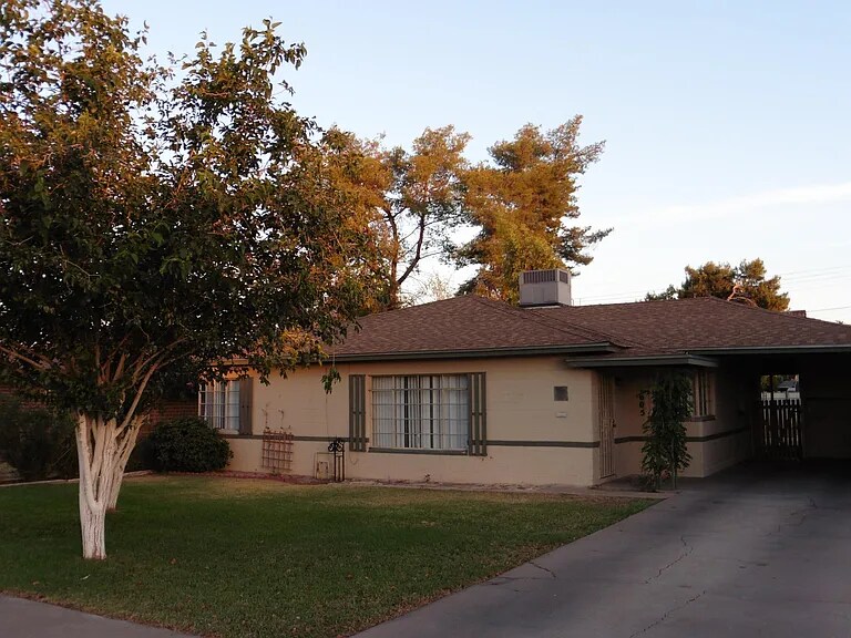
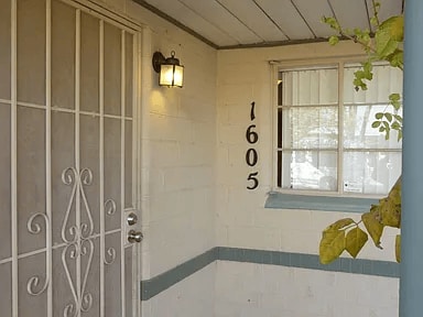
1605 W Fairmount Ave
Phoenix, AZ 85015
1 Day Ago
Favorites
602-341-3002
-
Bedrooms
3
-
Bathrooms
2
-
Square Feet
1,400 sq ft
-
Available
Available Now
1605 W Fairmount Ave

Favorites
About This Home
$3,000 deposit,
Available Now
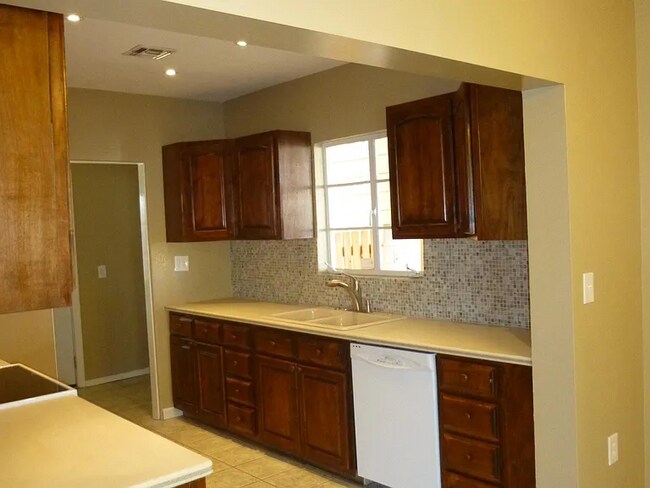
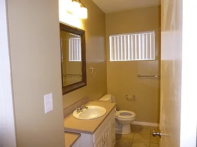
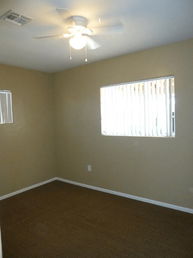
Welcome to 1605 W Fairmount Ave, a bright and well-maintained 3-bedroom, 2-bathroom home located in the peaceful and established St. Gregory neighborhood. With approximately 1,400 square feet of living space, this home offers a clean, comfortable environment in a central Phoenix location. Interior Features: Freshly painted throughout with neutral tile flooring in living areas Carpeted bedrooms for added comfort Spacious kitchen with ample counter space and included appliances Indoor laundry hookups for convenience Open layout with abundant natural light Outdoor Amenities: Large, fully fenced backyard with block wall Two outdoor storage sheds for tools or gear Expansive covered patio perfect for relaxing or entertaining Covered carport for protected parking Prime Location: Minutes to St. Joseph’s Hospital, Phoenix College, and Encanto Park Quick access to I-10 and I-17 freeways Close to Grand Avenue Arts District, downtown Phoenix, and top-rated schools like St. Gregory’s and Phoenix Christian Prep Whether you're commuting downtown, working at a nearby medical center, or looking for a peaceful spot in a connected neighborhood, this home offers the perfect balance of space, location, and livability. Schedule your showing today and see why 1605 W Fairmount is the ideal place to call home. Visit or contact for more information!
1605 W Fairmount Ave is a house located in Maricopa County and the 85015 ZIP Code. This area is served by the Osborn Elementary District attendance zone.
* Price shown is base rent and may not include non-optional fees and utilities.
Price, availability, fees, and any applicable rent special are subject to change without notice.
* Square footage definitions vary. Displayed square footage is approximate.
House Features
- Washer/Dryer
- Washer/Dryer Hookup
- Dishwasher
- Patio
Fees and Policies
The fees below are based on community-supplied data and may exclude additional fees and utilities.
- Dogs Allowed
-
Fees not specified
-
Weight limit--
-
Pet Limit--
Contact
- Listed by AZ Home For Us
- Phone Number
- Contact
Location
Get Directions
Amenities
- Washer/Dryer
- Washer/Dryer Hookup
- Dishwasher
- Patio
North Phoenix refers to the vast swath of land that stretches from Bethany Home Road up towards the Phoenix mountains. Bounded to the east by State Route 51 and to the west by 51st Avenue, North Phoenix is home a slew of diverse communities and neighborhoods all offering a variety of rentals ranging from the upscale to the more affordable. There are numerous golf courses and of course the mountains that offer residents a number of outdoor activities to engage in. For shopping and dining, residents head to Desert Ridge Marketplace on High Street, which is filled with upscale boutiques, nightlife hotspots, restaurants, and more. Interstate 17 and Route 101 make commuting around this desirable area simple.
Learn more about living in North Phoenix
Education
| Colleges & Universities | Distance | ||
|---|---|---|---|
| Colleges & Universities | Distance | ||
| Walk: | 17 min | 0.9 mi | |
| Drive: | 11 min | 4.0 mi | |
| Drive: | 10 min | 4.1 mi | |
| Drive: | 10 min | 4.5 mi |
1605 W Fairmount Ave is within 17 minutes or 0.9 mile from Phoenix College. It is also near Grand Canyon University and Arizona State Univ., Downtown.
Schools


Public Elementary & Middle School
Grades PK-8
420 Students
Attendance Zone
Public Elementary & Middle School
Grades PK-8
665 Students
Attendance Zone
Public Middle School
Grades 7-8
504 Students
Attendance Zone
Public High School
Grades 9-12
1,901 Students
Attendance Zone
Private Elementary, Middle & High School
Grades PK-12
473 Students
Nearby
School data provided by
 The GreatSchools Rating helps parents compare schools within a state based on a variety of school quality indicators and provides a helpful picture of how effectively each school serves all of its students. Ratings are on a scale of 1 (below average) to 10 (above average) and can include test scores, college readiness, academic progress, advanced courses, equity, discipline and attendance data. We also advise parents to visit schools, consider other information on school performance and programs, and consider family needs as part of the school selection process.
View GreatSchools Rating Methodology
Data provided by GreatSchools.org © 2025. All rights reserved.
View GreatSchools Rating Methodology
Data provided by GreatSchools.org © 2025. All rights reserved.
Transportation options available in Phoenix include Indian School/Central Ave, located 1.5 miles from 1605 W Fairmount Ave. 1605 W Fairmount Ave is near Phoenix Sky Harbor International, located 9.5 miles or 18 minutes away, and Phoenix-Mesa Gateway, located 36.3 miles or 50 minutes away.
| Transit / Subway | Distance | ||
|---|---|---|---|
| Transit / Subway | Distance | ||
|
|
Drive: | 4 min | 1.5 mi |
|
|
Drive: | 4 min | 1.7 mi |
|
|
Drive: | 4 min | 1.8 mi |
|
|
Drive: | 4 min | 1.8 mi |
|
|
Drive: | 5 min | 2.0 mi |
| Commuter Rail | Distance | ||
|---|---|---|---|
| Commuter Rail | Distance | ||
|
|
Drive: | 50 min | 37.4 mi |
| Airports | Distance | ||
|---|---|---|---|
| Airports | Distance | ||
|
Phoenix Sky Harbor International
|
Drive: | 18 min | 9.5 mi |
|
Phoenix-Mesa Gateway
|
Drive: | 50 min | 36.3 mi |
Time and distance from 1605 W Fairmount Ave.
| Shopping Centers | Distance | ||
|---|---|---|---|
| Shopping Centers | Distance | ||
| Walk: | 9 min | 0.5 mi | |
| Walk: | 12 min | 0.6 mi | |
| Walk: | 13 min | 0.7 mi |
1605 W Fairmount Ave has 3 shopping centers within 0.7 mile, which is about a 13-minute walk. The miles and minutes will be for the farthest away property.
| Parks and Recreation | Distance | ||
|---|---|---|---|
| Parks and Recreation | Distance | ||
|
Steele Indian School Park
|
Drive: | 4 min | 1.6 mi |
|
Japanese Friendship Garden
|
Drive: | 8 min | 3.2 mi |
|
Civic Space Park
|
Drive: | 9 min | 3.9 mi |
|
Margaret T. Hance Park
|
Drive: | 9 min | 4.4 mi |
|
Desert Storm Park
|
Drive: | 12 min | 5.7 mi |
1605 W Fairmount Ave has 5 parks within 5.7 miles, including Steele Indian School Park, Margaret T. Hance Park, and Japanese Friendship Garden.
| Hospitals | Distance | ||
|---|---|---|---|
| Hospitals | Distance | ||
| Drive: | 4 min | 1.7 mi | |
| Drive: | 6 min | 2.7 mi | |
| Drive: | 7 min | 3.0 mi |
1605 W Fairmount Ave has 3 hospitals within 3.0 miles, the nearest is St. Joseph's Hospital and Medical Center which is 1.7 miles away and a 4 minute drive.
| Military Bases | Distance | ||
|---|---|---|---|
| Military Bases | Distance | ||
| Drive: | 18 min | 9.4 mi | |
| Drive: | 32 min | 17.6 mi | |
| Drive: | 100 min | 75.1 mi |
1605 W Fairmount Ave has 3 military bases within 75.1 miles, the nearest is Phoenix Sky Harbor Airport Air Guard Station which is 9.4 miles away and a 18 minute drive.
You May Also Like
Similar Rentals Nearby
-
-
-
-
-
-
-
-
1 / 51

-
-


What Are Walk Score®, Transit Score®, and Bike Score® Ratings?
Walk Score® measures the walkability of any address. Transit Score® measures access to public transit. Bike Score® measures the bikeability of any address.
What is a Sound Score Rating?
A Sound Score Rating aggregates noise caused by vehicle traffic, airplane traffic and local sources

1605 W Fairmount Ave
Phoenix, AZ 85015