
1213 Walnut
1213 Walnut St,
Philadelphia, PA 19107
$2,540 - $5,400
Studio - 2 Beds
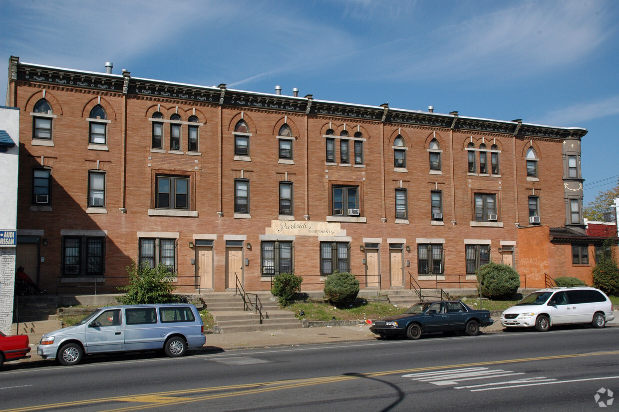
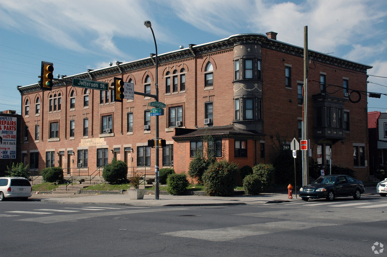

Thank you for visiting 1586-1598 N 52nd St in Philadelphia, PA. This community is located at 1586-1598 N. 52nd St. in Philadelphia. The team of leasing professionals is ready to help match you with your perfect new place. Be sure to check out the current floorplan options. At 1586-1598 N 52nd St you'll feel right at home. Stop by the community today.
1586-1598 N 52nd St is an apartment community located in Philadelphia County and the 19131 ZIP Code. This area is served by the The School District of Philadelphia attendance zone.
Though considered an urban community, the neighborhood of Wynnefield offers a great in-between of city living and suburban charm in West Philadelphia. Friendly neighbors and up-and-coming streets are immense perks of renting in this Philly neighborhood.
For its premier location approximately six miles northwest of Philadelphia’s bustling Center City, Wynnefield boasts affordable rental rates for apartments, condos, and houses. It doesn’t get much better than reasonably priced, family-friendly living just outside of Philly’s vibrant downtown district! In just minutes, you can admire the Liberty Bell, explore Philadelphia’s Magic Gardens, and have family-friendly adventures at Spruce Street Harbor Park!
Wynnefield houses the large Bala Golf Course, Wynnefield train station, and borders one of West Philly’s greatest natural treasures.
Learn more about living in WynnefieldCompare neighborhood and city base rent averages by bedroom.
| Wynnefield | Philadelphia, PA | |
|---|---|---|
| Studio | $1,139 | $1,410 |
| 1 Bedroom | $1,508 | $1,765 |
| 2 Bedrooms | $1,881 | $2,207 |
| 3 Bedrooms | $2,103 | $2,949 |
| Colleges & Universities | Distance | ||
|---|---|---|---|
| Colleges & Universities | Distance | ||
| Drive: | 5 min | 1.8 mi | |
| Drive: | 6 min | 1.9 mi | |
| Drive: | 5 min | 2.2 mi | |
| Drive: | 8 min | 2.8 mi |


Transportation options available in Philadelphia include Lancaster Avenue And 52Nd Street, located 0.2 mile from 1586-1598 N 52nd St. 1586-1598 N 52nd St is near Philadelphia International, located 9.5 miles or 24 minutes away, and Trenton Mercer, located 37.5 miles or 56 minutes away.
| Transit / Subway | Distance | ||
|---|---|---|---|
| Transit / Subway | Distance | ||
|
|
Walk: | 3 min | 0.2 mi |
|
|
Walk: | 6 min | 0.3 mi |
|
|
Walk: | 8 min | 0.4 mi |
|
|
Walk: | 8 min | 0.4 mi |
|
|
Walk: | 10 min | 0.5 mi |
| Commuter Rail | Distance | ||
|---|---|---|---|
| Commuter Rail | Distance | ||
|
|
Walk: | 17 min | 0.9 mi |
|
|
Drive: | 4 min | 1.7 mi |
|
|
Drive: | 5 min | 1.9 mi |
|
|
Drive: | 6 min | 2.3 mi |
|
|
Drive: | 7 min | 2.4 mi |
| Airports | Distance | ||
|---|---|---|---|
| Airports | Distance | ||
|
Philadelphia International
|
Drive: | 24 min | 9.5 mi |
|
Trenton Mercer
|
Drive: | 56 min | 37.5 mi |
Scores provided by
Traffic
BusyAirport
CalmBusinesses
BusyScores provided by
HowLoud What is a Sound Score Rating? A Sound Score Rating aggregates noise caused by vehicle traffic, airplane traffic and local sources. How It WorksTime and distance from 1586-1598 N 52nd St.
| Shopping Centers | Distance | ||
|---|---|---|---|
| Shopping Centers | Distance | ||
| Walk: | 7 min | 0.4 mi | |
| Walk: | 11 min | 0.6 mi | |
| Drive: | 3 min | 1.3 mi |
| Parks and Recreation | Distance | ||
|---|---|---|---|
| Parks and Recreation | Distance | ||
|
Fairmount Park
|
Walk: | 9 min | 0.5 mi |
|
Please Touch Museum
|
Walk: | 20 min | 1.0 mi |
|
Shofuso - Japanese House and Garden
|
Drive: | 5 min | 1.8 mi |
|
Arboretum of the Barnes Foundation
|
Drive: | 5 min | 1.9 mi |
|
Philadelphia Zoo
|
Drive: | 8 min | 2.8 mi |
| Hospitals | Distance | ||
|---|---|---|---|
| Hospitals | Distance | ||
| Drive: | 7 min | 2.4 mi | |
| Drive: | 12 min | 4.6 mi | |
| Drive: | 9 min | 4.7 mi |
| Military Bases | Distance | ||
|---|---|---|---|
| Military Bases | Distance | ||
| Drive: | 18 min | 9.6 mi |
What Are Walk Score®, Transit Score®, and Bike Score® Ratings?
Walk Score® measures the walkability of any address. Transit Score® measures access to public transit. Bike Score® measures the bikeability of any address.
What is a Sound Score Rating?
A Sound Score Rating aggregates noise caused by vehicle traffic, airplane traffic and local sources.

1586-1598 N 52nd St
Philadelphia, PA 19131


