
$3,300
/ Month
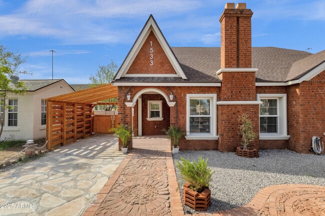
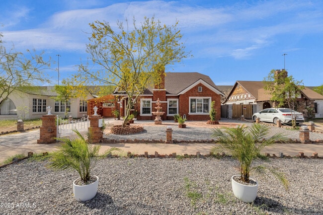
1533 W Culver St
Phoenix, AZ 85007
Today
|
Edit
Favorites
602-600-5387
-
Bedrooms
3
-
Bathrooms
3
-
Square Feet
2,100 sq ft
-
Available
Available Now
Highlights
- The property is located in a historic district
- Brick Veneer
- Breakfast Bar
- Central Air
- High Speed Internet
- Vinyl Flooring
1533 W Culver St

Favorites
About This Home
$4,400 deposit,
Available Now
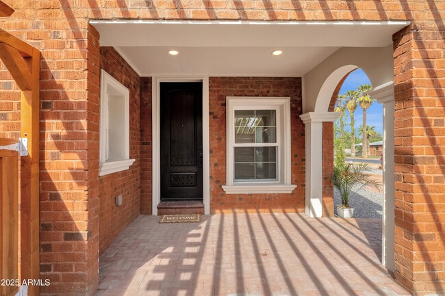
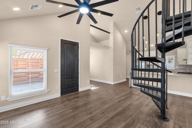
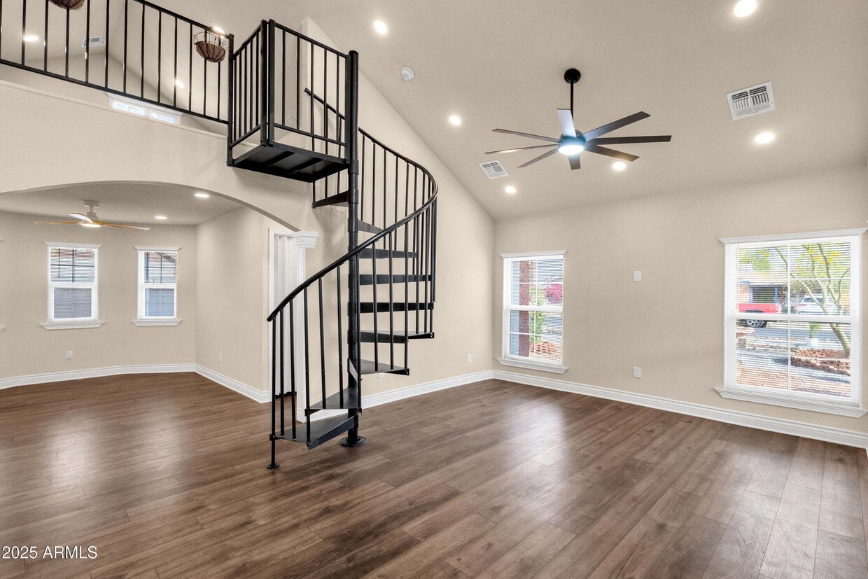
Introducing a Stunning Historic Home in the FQ Story District. This historic residence,recently rebuilt from the ground up with permits from the City of Phoenix,offers a perfect blend of modern upgrades and historic charm. The impressive home features 3 bedrooms,3 bathrooms,2 versatile lofts,and a finished basement,providing ample space for various needs. The home's recent completion includes all-new plumbing,a replaced underground sewer line,updated electrical systems,air conditioning,a new roof,and modern luxury vinyl plank (LVP) flooring throughout. The rear addition has been thoughtfully crafted to mirror the original architecture,ensuring it fits seamlessly with the home's historic character.
1533 W Culver St is a house located in Maricopa County and the 85007 ZIP Code. This area is served by the Phoenix Elementary District attendance zone.
* Price shown is base rent. Excludes user-selected optional fees and variable or usage-based fees and required charges due at or prior to move-in or at move-out. Price, availability, fees, and any applicable rent special are subject to change without notice.
* Square footage definitions vary. Displayed square footage is approximate.
Home Details
Year Built
Built in 2023
Bedrooms and Bathrooms
Primary Bathroom is a Full Bathroom
3 Bathrooms
3 Bedrooms
Home Design
Brick Veneer
Tile Roof
Interior Spaces
Vinyl Flooring
2,100 Sq Ft Home
1-Story Property
Kitchen
Breakfast Bar
Built-In Microwave
Laundry
Washer Hookup
Listing and Financial Details
Property Available on 8/15/25
12-Month Minimum Lease Term
Legal Lot and Block 2 / 34
Assessor Parcel Number 111-18-007
Location
The property is located in a historic district
Lot Details
5,945 Sq Ft Lot
Desert faces the front and back of the property
Block Wall Fence
Parking
Side or Rear Entrance to Parking
2 Carport Spaces
Schools
Kenilworth Elementary School
Central High School
Utilities
Central Air
High Speed Internet
Heating Available
Cable TV Available
Community Details
Overview
No Home Owners Association
Fq Story Addition Plat E Subdivision
Contact
- Listed by Phillip J Norris | Real Broker
- Phone Number
- Contact
-
Source
Arizona Regional MLS
Copyright 2025 Arizona Regional MLS. All rights reserved. Information is deemed reliable but not guaranteed.
Location
Get Directions
A major art hub in Phoenix, Roosevelt is alive with revitalized parks, distinct shops and local small businesses, topnotch restaurants, and Craftsman-style architecture.
Roosevelt Row, or “RoRo”, is a very walkable arts district filled with impressive sculptures, colorful murals, and art exhibits. During the first Friday of every month, locals are given the opportunity to immerse themselves in culture and art with the First Friday Art Walk.
Residents are encouraged to stroll through the studios and view the newest collections, sip cocktails, and mingle with the community artists.
When it comes to food on RoRo, the locals rave about the Dressing Room and its international street fare. The Japanese Friendship Garden is a serene, park-like setting that includes a koi pond, cascading waterfall, and tea garden – it’s the ideal place for meditation. The Valley Metro Rail connects residents to the airport’s sky train, zoo, and Desert Botanical Garden.
Learn more about living in Roosevelt Row
Education
| Colleges & Universities | Distance | ||
|---|---|---|---|
| Colleges & Universities | Distance | ||
| Drive: | 4 min | 1.9 mi | |
| Drive: | 6 min | 2.0 mi | |
| Drive: | 5 min | 2.3 mi | |
| Drive: | 11 min | 5.2 mi |
1533 W Culver St is within 6 minutes or 2.0 miles from Phoenix College. It is also near Arizona State Univ., Downtown and University of Arizona.
Schools


Public Elementary & Middle School
Grades PK-8
488 Students
Attendance Zone
Public High School
Grades 9-12
1,901 Students
Attendance Zone
Private Elementary School
Grades PK-4
Nearby
Private Elementary & Middle School
Grades K-8
166 Students
Nearby
Private Elementary School
Grades PK-K
63 Students
Nearby
Private Middle & High School
Grades 6-12
Nearby
School data provided by
 The GreatSchools Rating helps parents compare schools within a state based on a variety of school quality indicators and provides a helpful picture of how effectively each school serves all of its students. Ratings are on a scale of 1 (below average) to 10 (above average) and can include test scores, college readiness, academic progress, advanced courses, equity, discipline and attendance data. We also advise parents to visit schools, consider other information on school performance and programs, and consider family needs as part of the school selection process.
View GreatSchools Rating Methodology
Data provided by GreatSchools.org © 2025. All rights reserved.
View GreatSchools Rating Methodology
Data provided by GreatSchools.org © 2025. All rights reserved.
Transportation options available in Phoenix include Mcdowell/Central Ave, located 1.4 miles from 1533 W Culver St. 1533 W Culver St is near Phoenix Sky Harbor International, located 7.4 miles or 13 minutes away, and Phoenix-Mesa Gateway, located 34.2 miles or 45 minutes away.
| Transit / Subway | Distance | ||
|---|---|---|---|
| Transit / Subway | Distance | ||
|
|
Drive: | 3 min | 1.4 mi |
|
|
Drive: | 4 min | 1.4 mi |
|
|
Drive: | 4 min | 1.6 mi |
|
|
Drive: | 4 min | 1.8 mi |
|
|
Drive: | 4 min | 1.9 mi |
| Commuter Rail | Distance | ||
|---|---|---|---|
| Commuter Rail | Distance | ||
|
|
Drive: | 45 min | 35.3 mi |
| Airports | Distance | ||
|---|---|---|---|
| Airports | Distance | ||
|
Phoenix Sky Harbor International
|
Drive: | 13 min | 7.4 mi |
|
Phoenix-Mesa Gateway
|
Drive: | 45 min | 34.2 mi |
Time and distance from 1533 W Culver St.
| Shopping Centers | Distance | ||
|---|---|---|---|
| Shopping Centers | Distance | ||
| Walk: | 17 min | 0.9 mi | |
| Drive: | 4 min | 1.4 mi | |
| Drive: | 3 min | 1.4 mi |
1533 W Culver St has 3 shopping centers within 1.4 miles, which is about a 3-minute walk. The miles and minutes will be for the farthest away property.
| Parks and Recreation | Distance | ||
|---|---|---|---|
| Parks and Recreation | Distance | ||
|
Japanese Friendship Garden
|
Drive: | 3 min | 1.3 mi |
|
Civic Space Park
|
Drive: | 4 min | 1.8 mi |
|
Colter Park
|
Drive: | 4 min | 2.1 mi |
|
Children's Museum of Phoenix
|
Drive: | 5 min | 2.2 mi |
|
Margaret T. Hance Park
|
Drive: | 6 min | 2.7 mi |
1533 W Culver St has 5 parks within 2.7 miles, including Margaret T. Hance Park, Japanese Friendship Garden, and Civic Space Park.
| Hospitals | Distance | ||
|---|---|---|---|
| Hospitals | Distance | ||
| Drive: | 5 min | 2.1 mi | |
| Drive: | 4 min | 2.2 mi | |
| Drive: | 5 min | 2.2 mi |
1533 W Culver St has 3 hospitals within 2.2 miles, the nearest is St. Joseph's Hospital and Medical Center which is 2.1 miles away and a 5 minute drive.
| Military Bases | Distance | ||
|---|---|---|---|
| Military Bases | Distance | ||
| Drive: | 14 min | 7.2 mi | |
| Drive: | 29 min | 21.2 mi | |
| Drive: | 97 min | 73.7 mi |
1533 W Culver St has 3 military bases within 73.7 miles, the nearest is Phoenix Sky Harbor Airport Air Guard Station which is 7.2 miles away and a 14 minute drive.
You May Also Like
Similar Rentals Nearby
-
-
-
-
-
-
-
-
1 / 16

-
-
1 / 47


What Are Walk Score®, Transit Score®, and Bike Score® Ratings?
Walk Score® measures the walkability of any address. Transit Score® measures access to public transit. Bike Score® measures the bikeability of any address.
What is a Sound Score Rating?
A Sound Score Rating aggregates noise caused by vehicle traffic, airplane traffic and local sources
1533 W Culver St
Phoenix, AZ 85007