
$8,500
/ Month
1511 Pandora Ave
Los Angeles, CA 90024
Today
Favorites
310-780-0214
-
Bedrooms
3
-
Bathrooms
2
-
Square Feet
1,912 sq ft
-
Available
Available Now
Highlights
- Living Room with Fireplace
- Wood Flooring
- Spanish Architecture
- Furnished
- Breakfast Area or Nook
- 2 Car Attached Garage
1511 Pandora Ave

Favorites
About This Home
$8,500 deposit,
Available Now
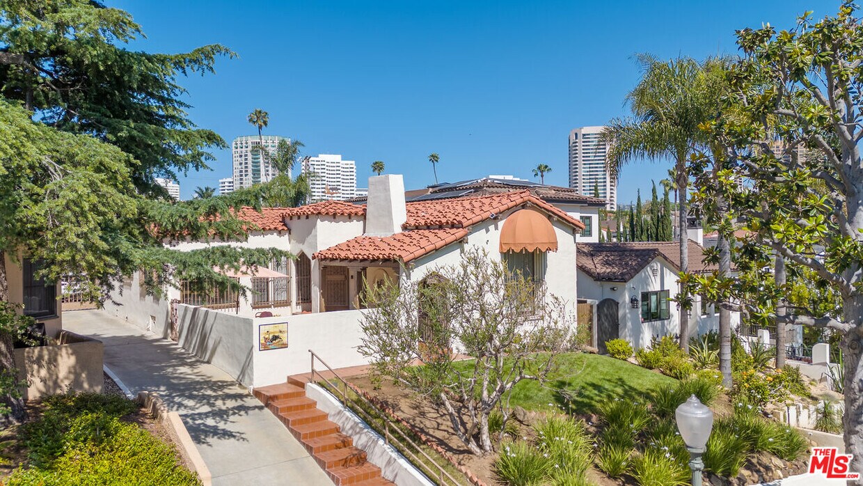
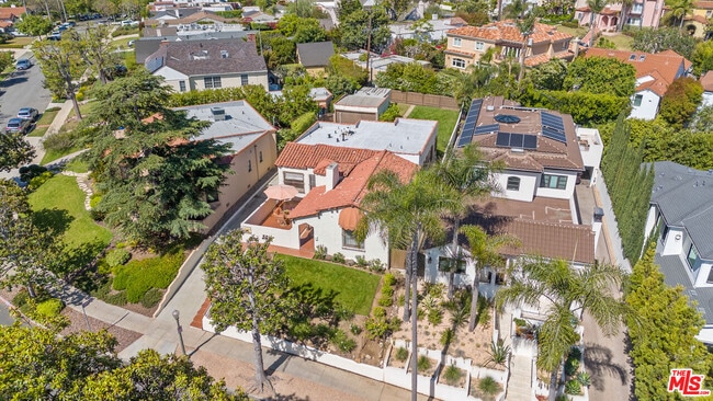
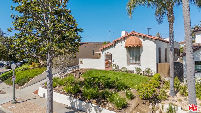
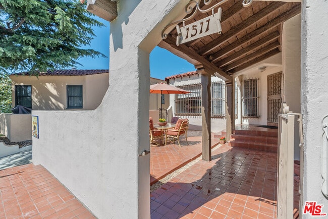
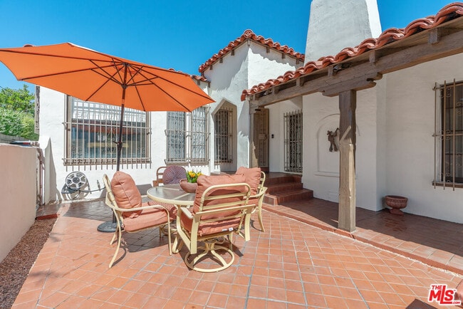
Picturesque Spanish home set up off of street in idyllic Westwood neighborhood. This home is a classic. It's a lovingly maintained, one-story Spanish home with the charm of yesteryear including beamed ceilings, archways, lathe and plaster walls, an open-air courtyard and pristine hardwood floors throughout. The kitchen has been remodeled with high end cabinetry and appliances. The backyard offers plenty of space to play and entertain and there is ample storage in the detached garage. All of this is situated just minutes from Century City, Beverly Hills and UCLA. Per the home school is Fairburn Elementary. MLS# 25541429
1511 Pandora Ave is a house located in Los Angeles County and the 90024 ZIP Code. This area is served by the Los Angeles Unified attendance zone.
* Price shown is base rent and may not include non-optional fees and utilities. Price, availability, fees, and any applicable rent special are subject to change without notice.
* Square footage definitions vary. Displayed square footage is approximate.
Home Details
Home Type
Single Family Detached Home
Year Built
Built in 1929
Bedrooms and Bathrooms
2 Bathrooms
3 Bedrooms
Flooring
Wood
Tile
Home Design
Spanish Architecture
Home Security
Window Bars
Interior Spaces
Living Room with Fireplace
Furnished
Formal Entry
Dining Room
Center Hall
1,912 Sq Ft Home
1-Story Property
Kitchen
Breakfast Area or Nook
Oven or Range
Microwave
Dishwasher
Disposal
Laundry
Laundry Room
Dryer
Washer
Listing and Financial Details
Security Deposit $8,500
12 Month Lease Term
Assessor Parcel Number 4326-019-029
Tenant pays for gas, insurance, trash collection, water, electricity
Lot Details
7,710 Sq Ft Lot
Property is zoned LAR1
Outdoor Features
Open Patio
Parking
2 Car Attached Garage
Auto Driveway Gate
3 Open Parking Spaces
Utilities
Forced Air Heating System
Community Details
Pet Policy
Call for details about the types of pets allowed
Fees and Policies
The fees below are based on community-supplied data and may exclude additional fees and utilities.
Pet policies are negotiable.
Details
Property Information
-
Furnished Units Available
Contact
- Listed by Lorin Ruttenberg | Compass
- Phone Number
- Contact
-
Source
 MLS(TM)/CLAW
Copyright 2025 TheMLS/CLAW. All rights reserved. Information is deemed reliable but not guaranteed.
Location
Get Directions
Amenities
- Washer/Dryer
- Washer/Dryer Hookup
- Dishwasher
- Disposal
- Microwave
- Refrigerator
- Hardwood Floors
- Tile Floors
- Dining Room
- Furnished
Home to UCLA, Westwood lies on the west side of the city and is considered to be one of Los Angeles’ premier neighborhoods. Bordered by Beverly Hills, Bel Air, Brentwood, and Century City, multimillion dollar homes populate the landscape and students pay a premium to rent near campus.
The university itself serves as a major cultural center for the community, including on-campus attractions (such as the Fowler Museum and the Franklin D. Murphy Sculpture Garden) and university-affiliated venues off-campus (The Hammer Museum, the Geffen Playhouse), as well as the presence of thousands of students and faculty members throughout the neighborhood.
Directly south of campus, Westwood Village is a historic shopping district that features blocks of restaurants and businesses catering to both students and the neighborhood’s larger workforce. Many prominent corporations and law offices are found along Wilshire Boulevard, one of the busiest east-west transit corridors across the city.
Learn more about living in Westwood
Education
| Colleges & Universities | Distance | ||
|---|---|---|---|
| Colleges & Universities | Distance | ||
| Drive: | 6 min | 2.3 mi | |
| Drive: | 9 min | 4.1 mi | |
| Drive: | 10 min | 4.2 mi | |
| Drive: | 10 min | 4.3 mi |
1511 Pandora Ave is within 6 minutes or 2.3 miles from UCLA. It is also near Santa Monica Coll., Academy and The Art Inst., Los Angeles.
Schools


Public Elementary School
Grades K-5
436 Students
Attendance Zone
Public Elementary School
Grades K-5
393 Students
Nearby
Charter Middle School
Grades 6-8
492 Students
Attendance Zone
Charter High School
Grades 9-12
1,338 Students
Attendance Zone
Private Elementary School
Grades K-1
Nearby
Private Elementary & Middle School
Grades PK-8
452 Students
Nearby
Private Elementary, Middle & High School
Grades PK-12
Nearby
School data provided by
 The GreatSchools Rating helps parents compare schools within a state based on a variety of school quality indicators and provides a helpful picture of how effectively each school serves all of its students. Ratings are on a scale of 1 (below average) to 10 (above average) and can include test scores, college readiness, academic progress, advanced courses, equity, discipline and attendance data. We also advise parents to visit schools, consider other information on school performance and programs, and consider family needs as part of the school selection process.
View GreatSchools Rating Methodology
Data provided by GreatSchools.org © 2025. All rights reserved.
View GreatSchools Rating Methodology
Data provided by GreatSchools.org © 2025. All rights reserved.
Transportation options available in Los Angeles include Westwood/Rancho Park, located 2.3 miles from 1511 Pandora Ave. 1511 Pandora Ave is near Los Angeles International, located 10.9 miles or 19 minutes away, and Bob Hope, located 19.4 miles or 29 minutes away.
| Transit / Subway | Distance | ||
|---|---|---|---|
| Transit / Subway | Distance | ||
|
|
Drive: | 6 min | 2.3 mi |
| Drive: | 5 min | 2.5 mi | |
|
|
Drive: | 7 min | 3.0 mi |
|
|
Drive: | 8 min | 3.3 mi |
|
|
Drive: | 9 min | 4.5 mi |
| Commuter Rail | Distance | ||
|---|---|---|---|
| Commuter Rail | Distance | ||
|
|
Drive: | 25 min | 13.0 mi |
|
|
Drive: | 26 min | 13.4 mi |
|
|
Drive: | 23 min | 14.3 mi |
|
|
Drive: | 28 min | 14.3 mi |
|
|
Drive: | 23 min | 15.7 mi |
| Airports | Distance | ||
|---|---|---|---|
| Airports | Distance | ||
|
Los Angeles International
|
Drive: | 19 min | 10.9 mi |
|
Bob Hope
|
Drive: | 29 min | 19.4 mi |
Time and distance from 1511 Pandora Ave.
| Shopping Centers | Distance | ||
|---|---|---|---|
| Shopping Centers | Distance | ||
| Walk: | 11 min | 0.6 mi | |
| Drive: | 4 min | 1.2 mi | |
| Drive: | 3 min | 1.3 mi |
1511 Pandora Ave has 3 shopping centers within 1.3 miles, which is about a 3-minute walk. The miles and minutes will be for the farthest away property.
| Parks and Recreation | Distance | ||
|---|---|---|---|
| Parks and Recreation | Distance | ||
|
Mathias Botanical Garden
|
Drive: | 5 min | 1.8 mi |
|
Hannah Carter Japanese Garden
|
Drive: | 6 min | 2.4 mi |
|
Virginia Robinson Gardens
|
Drive: | 8 min | 2.9 mi |
|
Zimmer Children's Museum
|
Drive: | 8 min | 4.2 mi |
|
Franklin Canyon Park
|
Drive: | 16 min | 5.3 mi |
1511 Pandora Ave has 5 parks within 5.3 miles, including Mathias Botanical Garden, Hannah Carter Japanese Garden, and Virginia Robinson Gardens.
| Hospitals | Distance | ||
|---|---|---|---|
| Hospitals | Distance | ||
| Drive: | 6 min | 2.2 mi | |
| Drive: | 6 min | 2.3 mi | |
| Drive: | 8 min | 3.7 mi |
1511 Pandora Ave has 3 hospitals within 3.7 miles, the nearest is Ronald Reagan UCLA Medical Center which is 2.2 miles away and a 6 minute drive.
| Military Bases | Distance | ||
|---|---|---|---|
| Military Bases | Distance | ||
| Drive: | 19 min | 13.5 mi |
1511 Pandora Ave is 13.5 miles and a 19 minute drive from Los Angeles Air Force Base.
You May Also Like
Similar Rentals Nearby


What Are Walk Score®, Transit Score®, and Bike Score® Ratings?
Walk Score® measures the walkability of any address. Transit Score® measures access to public transit. Bike Score® measures the bikeability of any address.
What is a Sound Score Rating?
A Sound Score Rating aggregates noise caused by vehicle traffic, airplane traffic and local sources

1511 Pandora Ave
Los Angeles, CA 90024