

$7,340
/ Month
15 S St NE
Washington, DC 20002
Today
Favorites
202-255-3389
-
Bedrooms
5
-
Bathrooms
4
-
Square Feet
2,258 sq ft
-
Available
Available Now
Highlights
- Federal Architecture
- Central Heating and Cooling System
- 60+ Gallon Tank
15 S St NE

Favorites
About This Home
Available Now
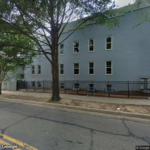
Spacious Duplex with In-Law Suite This sun-filled, corner duplex offers a wide-open floor plan with Carrara quartz countertops and custom neutral cabinetry. The modern yet minimal design provides the perfect backdrop for bold personal touches. Each level features its own master suite, ensuring comfort and privacy for everyone. Enjoy a private rear deck, fenced yard, and the convenience of an in-law suite. Situated on a beautiful corner lot in Eckington, this home is within walking distance to NoMa and Metro.
15 S St NE is a townhome located in District of Columbia County and the 20002 ZIP Code. This area is served by the District Of Columbia Public Schools attendance zone.
* Price shown is base rent. Excludes user-selected optional fees and variable or usage-based fees and required charges due at or prior to move-in or at move-out. Price, availability, fees, and any applicable rent special are subject to change without notice.
* Square footage definitions vary. Displayed square footage is approximate.
Home Details
Home Type
End Unit Townhome
Year Built
Built in 1905
Bedrooms and Bathrooms
5 Bedrooms | 2 Main Level Bedrooms
4 Full Bathrooms
Home Design
Federal Architecture
Brick Exterior Construction
Brick Foundation
Interior Spaces
2,258 Sq Ft Home
Property has 2 Levels
Listing and Financial Details
Security Deposit $7,340
12-Month Lease Term
Available 9/5/25
$100 Application Fee
Assessor Parcel Number 3512//2003
No Smoking Allowed
Residential Lease
Lot Details
810 Sq Ft Lot
Parking
Off-Street Parking
Utilities
Central Heating and Cooling System
60+ Gallon Tank
Community Details
Overview
Eckington Community
Eckington Subdivision
Pet Policy
No Pets Allowed
Contact
- Listed by LaTawnya S Brown | McWilliams/Ballard, Inc.
- Phone Number
- Contact
-
Source
 Bright MLS, Inc.
Copyright © 2025 Bright MLS, Inc.
Location
Get Directions
Located in northeast Washington, DC, Eckington sits less than a mile from Howard University and the United States Capitol. Surrounded by other popular neighborhoods in the city such as Brentwood and Bloomingdale, Eckington provides an affordable alternative to these traditionally desired locations with the same enviable proximity to the capital’s downtown district. Filled with professionals and the perfect mix of urban and residential features, Eckington’s residential streets display a broad palette of colors, from pink and yellow to green and blue, in its rows of two-level Victorian townhomes and federal flat-roofed buildings.
Learn more about living in Eckington
Education
| Colleges & Universities | Distance | ||
|---|---|---|---|
| Colleges & Universities | Distance | ||
| Drive: | 3 min | 1.3 mi | |
| Drive: | 2 min | 1.3 mi | |
| Drive: | 4 min | 1.4 mi | |
| Drive: | 5 min | 1.7 mi |
15 S St NE is within 3 minutes or 1.3 miles from Trinity Washington University. It is also near Howard University and Gallaudet University.
Schools


Public Elementary School
Grades PK-5
338 Students
Attendance Zone
Public Middle School
Grades 6-8
222 Students
Attendance Zone
Public High School
Grades 9-12
868 Students
Attendance Zone
Private Elementary & Middle School
Grades PK-8
Nearby
Private Elementary, Middle & High School
Grades 1-12
Nearby
School data provided by
 The GreatSchools Rating helps parents compare schools within a state based on a variety of school quality indicators and provides a helpful picture of how effectively each school serves all of its students. Ratings are on a scale of 1 (below average) to 10 (above average) and can include test scores, college readiness, academic progress, advanced courses, equity, discipline and attendance data. We also advise parents to visit schools, consider other information on school performance and programs, and consider family needs as part of the school selection process.
View GreatSchools Rating Methodology
Data provided by GreatSchools.org © 2025. All rights reserved.
View GreatSchools Rating Methodology
Data provided by GreatSchools.org © 2025. All rights reserved.
Transportation options available in Washington include Noma-Gallaudet U, located 0.7 mile from 15 S St NE. 15 S St NE is near Ronald Reagan Washington Ntl, located 6.7 miles or 12 minutes away, and Washington Dulles International, located 29.4 miles or 46 minutes away.
| Transit / Subway | Distance | ||
|---|---|---|---|
| Transit / Subway | Distance | ||
|
|
Walk: | 13 min | 0.7 mi |
|
|
Walk: | 17 min | 0.9 mi |
|
|
Drive: | 2 min | 1.2 mi |
| Drive: | 2 min | 1.3 mi | |
|
|
Drive: | 2 min | 1.4 mi |
| Commuter Rail | Distance | ||
|---|---|---|---|
| Commuter Rail | Distance | ||
|
|
Drive: | 2 min | 1.3 mi |
|
|
Drive: | 3 min | 1.4 mi |
|
|
Drive: | 5 min | 2.5 mi |
|
|
Drive: | 5 min | 2.5 mi |
|
|
Drive: | 9 min | 5.3 mi |
| Airports | Distance | ||
|---|---|---|---|
| Airports | Distance | ||
|
Ronald Reagan Washington Ntl
|
Drive: | 12 min | 6.7 mi |
|
Washington Dulles International
|
Drive: | 46 min | 29.4 mi |
Time and distance from 15 S St NE.
| Shopping Centers | Distance | ||
|---|---|---|---|
| Shopping Centers | Distance | ||
| Walk: | 16 min | 0.8 mi | |
| Drive: | 3 min | 1.2 mi | |
| Drive: | 2 min | 1.5 mi |
15 S St NE has 3 shopping centers within 1.5 miles, which is about a 2-minute walk. The miles and minutes will be for the farthest away property.
| Parks and Recreation | Distance | ||
|---|---|---|---|
| Parks and Recreation | Distance | ||
|
Carter G. Woodson Home National Historic Site
|
Drive: | 3 min | 1.2 mi |
|
Marian Koshland Science Museum
|
Drive: | 2 min | 1.5 mi |
|
Mary McLeod Bethune Council House NHS
|
Drive: | 4 min | 2.0 mi |
|
Pennsylvania Avenue National Historic Site
|
Drive: | 4 min | 2.1 mi |
|
Meridian Hill Park
|
Drive: | 6 min | 2.1 mi |
15 S St NE has 5 parks within 2.1 miles, including Carter G. Woodson Home National Historic Site, Marian Koshland Science Museum, and Mary McLeod Bethune Council House NHS.
| Hospitals | Distance | ||
|---|---|---|---|
| Hospitals | Distance | ||
| Walk: | 21 min | 1.1 mi | |
| Drive: | 2 min | 1.3 mi | |
| Drive: | 4 min | 1.9 mi |
15 S St NE has 3 hospitals within 1.9 miles, the nearest is Howard University Hospital which is 1.1 miles away and a 21 minute walk.
| Military Bases | Distance | ||
|---|---|---|---|
| Military Bases | Distance | ||
| Drive: | 4 min | 1.8 mi | |
| Drive: | 7 min | 3.6 mi |
15 S St NE is 1.8 miles from US Soldiers & Airmens Home, and is convenient to other military bases, including Washington Navy Yard.
You May Also Like
Similar Rentals Nearby
-
-

-

-

-
-
-
-
-
1 / 45

-


What Are Walk Score®, Transit Score®, and Bike Score® Ratings?
Walk Score® measures the walkability of any address. Transit Score® measures access to public transit. Bike Score® measures the bikeability of any address.
What is a Sound Score Rating?
A Sound Score Rating aggregates noise caused by vehicle traffic, airplane traffic and local sources
15 S St NE
Washington, DC 20002