

$3,100
Total Monthly Price
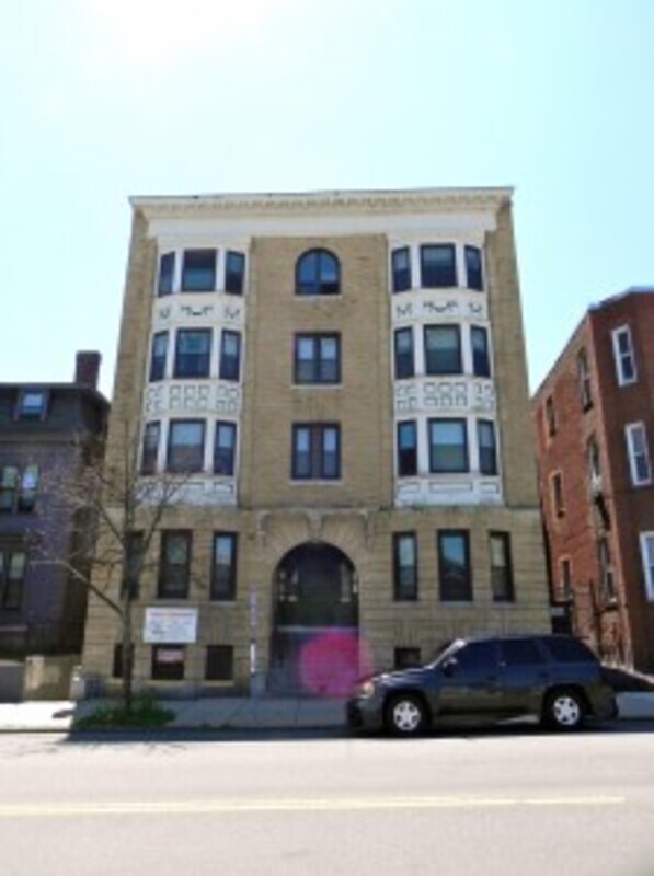
1458 Tremont St
Boston, MA 02120
Favorites
1458 Tremont St

Favorites
Check Back Soon for Upcoming Availability
| Beds | Baths | Average SF |
|---|---|---|
| 3 Bedrooms 3 Bedrooms 3 Br | 1 Bath 1 Bath 1 Ba | 1,100 SF |
About This Property
Gorgeous apartment with an open floor plan and large foyer entry area. The livingroom has bay windows, hardwood floors and high ceilings. All the bedrooms are equal size with large closets and full size windows. The bathroom is modern with tile floors, updated vanity and standup shower. The Kitchen is "Eat-in" with tile floors updated and modern cabinets with granite countertops. Minutes to NU, Wentworth, Longwood, Mass Art, Mass School of Pharmacy and both the "E" & Orange Line train. Please use our online application: https://bostongreenrealtyllc.managebuilding.com/Resident/rental-application
1458 Tremont St is a condo located in Suffolk County and the 02120 ZIP Code. This area is served by the Boston Public Schools attendance zone.
1458 Tremont St,
Boston,
MA
02120
Boston has been shaping American history since 1630, and living here means that past is never far from the present. As Massachusetts' capital and New England's cultural and financial center, the city carries real weight — intellectually, economically, and architecturally. More than 50 colleges and universities call the greater Boston area home, with institutions like Northeastern, Boston College, and Berklee College of Music woven directly into the city's neighborhoods. That academic presence fuels a steady demand for innovation, drawing employers in life sciences, technology, finance, and healthcare.
Neighborhoods here each carry a distinct personality. Beacon Hill delivers narrow gas-lit streets and Greek Revival rowhouses, while Back Bay is known for Victorian brownstones and the broad sweep of Commonwealth Avenue.
Learn more about living in Boston
Education
| Colleges & Universities | Distance | ||
|---|---|---|---|
| Colleges & Universities | Distance | ||
| Walk: | 8 min | 0.5 mi | |
| Walk: | 10 min | 0.5 mi | |
| Walk: | 10 min | 0.5 mi | |
| Drive: | 4 min | 1.8 mi |
1458 Tremont St is within 8 minutes or 0.5 mile from Wentworth Inst. of Technology. It is also near MCPHS University, Boston and MassArt.
Schools


Public Elementary & Middle School
Grades PK-8
355 Students
Nearby
Public High School
Grades 9-12
358 Students
Nearby
Private Elementary, Middle & High School
Grades K-12
478 Students
Nearby
Private Elementary, Middle & High School
Grades K-12
91 Students
Nearby
Private Elementary School
Grades PK-5
202 Students
Nearby
School data provided by
 The GreatSchools Rating helps parents compare schools within a state based on a variety of school quality indicators and provides a helpful picture of how effectively each school serves all of its students. Ratings are on a scale of 1 (below average) to 10 (above average) and can include test scores, college readiness, academic progress, advanced courses, equity, discipline and attendance data. We also advise parents to visit schools, consider other information on school performance and programs, and consider family needs as part of the school selection process.
View GreatSchools Rating Methodology
Data provided by GreatSchools.org © 2026. All rights reserved.
View GreatSchools Rating Methodology
Data provided by GreatSchools.org © 2026. All rights reserved.
Transportation options available in Boston include Roxbury Crossing Station, located 0.2 mile from 1458 Tremont St. 1458 Tremont St is near General Edward Lawrence Logan International, located 6.7 miles or 13 minutes away.
| Transit / Subway | Distance | ||
|---|---|---|---|
| Transit / Subway | Distance | ||
|
|
Walk: | 4 min | 0.2 mi |
|
|
Walk: | 9 min | 0.5 mi |
|
|
Walk: | 9 min | 0.5 mi |
|
|
Walk: | 10 min | 0.5 mi |
|
|
Walk: | 10 min | 0.5 mi |
| Commuter Rail | Distance | ||
|---|---|---|---|
| Commuter Rail | Distance | ||
|
|
Walk: | 12 min | 0.6 mi |
| Drive: | 5 min | 2.1 mi | |
|
|
Drive: | 4 min | 2.1 mi |
|
|
Drive: | 8 min | 2.2 mi |
|
|
Drive: | 9 min | 4.9 mi |
| Airports | Distance | ||
|---|---|---|---|
| Airports | Distance | ||
|
General Edward Lawrence Logan International
|
Drive: | 13 min | 6.7 mi |
Walkability Near 1458 Tremont St Boston, MA 02120
Getting Around
 What do Walkability, Transit, Drivability, and Bikeability mean?
Walkability measures the walking distance to day-to-day needs.
Transit measures access to public transportation.
Drivability measures congestion, parking availability, and access to major roads.
Bikeability measures the suitability for cycling.
How It Works
What do Walkability, Transit, Drivability, and Bikeability mean?
Walkability measures the walking distance to day-to-day needs.
Transit measures access to public transportation.
Drivability measures congestion, parking availability, and access to major roads.
Bikeability measures the suitability for cycling.
How It Works
Exceptionally Walkable
Walkability
100
/ 100
Exceptional Public Transit
Transit
100
/ 100
Fairly Drivable
Drivability
40
/ 100
Moderately Bikeable
Bikeability
70
/ 100
Scores provided by
-
Soundscore™
-
/ 100
Traffic
-Airport
-Businesses
-Scores provided by
HowLoud What is a Sound Score Rating? A Sound Score Rating aggregates noise caused by vehicle traffic, airplane traffic and local sources. How It WorksTime and distance from 1458 Tremont St.
| Shopping Centers | Distance | ||
|---|---|---|---|
| Shopping Centers | Distance | ||
| Walk: | 17 min | 0.9 mi | |
| Drive: | 3 min | 1.7 mi | |
| Drive: | 11 min | 5.9 mi |
1458 Tremont St has 3 shopping centers within 5.9 miles, which is about a 11-minute drive. The miles and minutes will be for the farthest away property.
| Parks and Recreation | Distance | ||
|---|---|---|---|
| Parks and Recreation | Distance | ||
|
Roxbury Heritage State Park
|
Walk: | 9 min | 0.5 mi |
|
Charles River Reservation
|
Drive: | 5 min | 2.2 mi |
|
Frederick Law Olmsted National Historic Site
|
Drive: | 5 min | 2.2 mi |
|
John Fitzgerald Kennedy National Historic Site
|
Drive: | 6 min | 2.2 mi |
|
Coit Observatory
|
Drive: | 5 min | 2.6 mi |
1458 Tremont St has 5 parks within 2.6 miles, including Roxbury Heritage State Park, Charles River Reservation, and Coit Observatory.
| Hospitals | Distance | ||
|---|---|---|---|
| Hospitals | Distance | ||
| Walk: | 12 min | 0.6 mi | |
| Walk: | 12 min | 0.7 mi | |
| Walk: | 13 min | 0.7 mi |
1458 Tremont St has 3 hospitals within 0.7 mile, the nearest is Brigham and Women's Hospital which is 0.6 mile away and a 12 minute walk.
| Military Bases | Distance | ||
|---|---|---|---|
| Military Bases | Distance | ||
| Drive: | 28 min | 15.2 mi | |
| Drive: | 31 min | 15.7 mi | |
| Drive: | 38 min | 23.0 mi |
1458 Tremont St has 3 military bases within 23.0 miles, the nearest is US Military Reservation which is 15.2 miles away and a 28 minute drive.
You May Also Like
Similar Rentals Nearby


What Are Walk Score®, Transit Score®, and Bike Score® Ratings?
Walk Score® measures the walkability of any address. Transit Score® measures access to public transit. Bike Score® measures the bikeability of any address.
What is a Sound Score Rating?
A Sound Score Rating aggregates noise caused by vehicle traffic, airplane traffic and local sources.
1458 Tremont St
Boston, MA 02120