
$2,500
/ Month
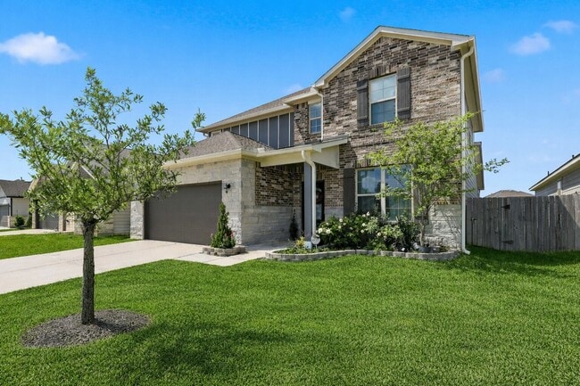
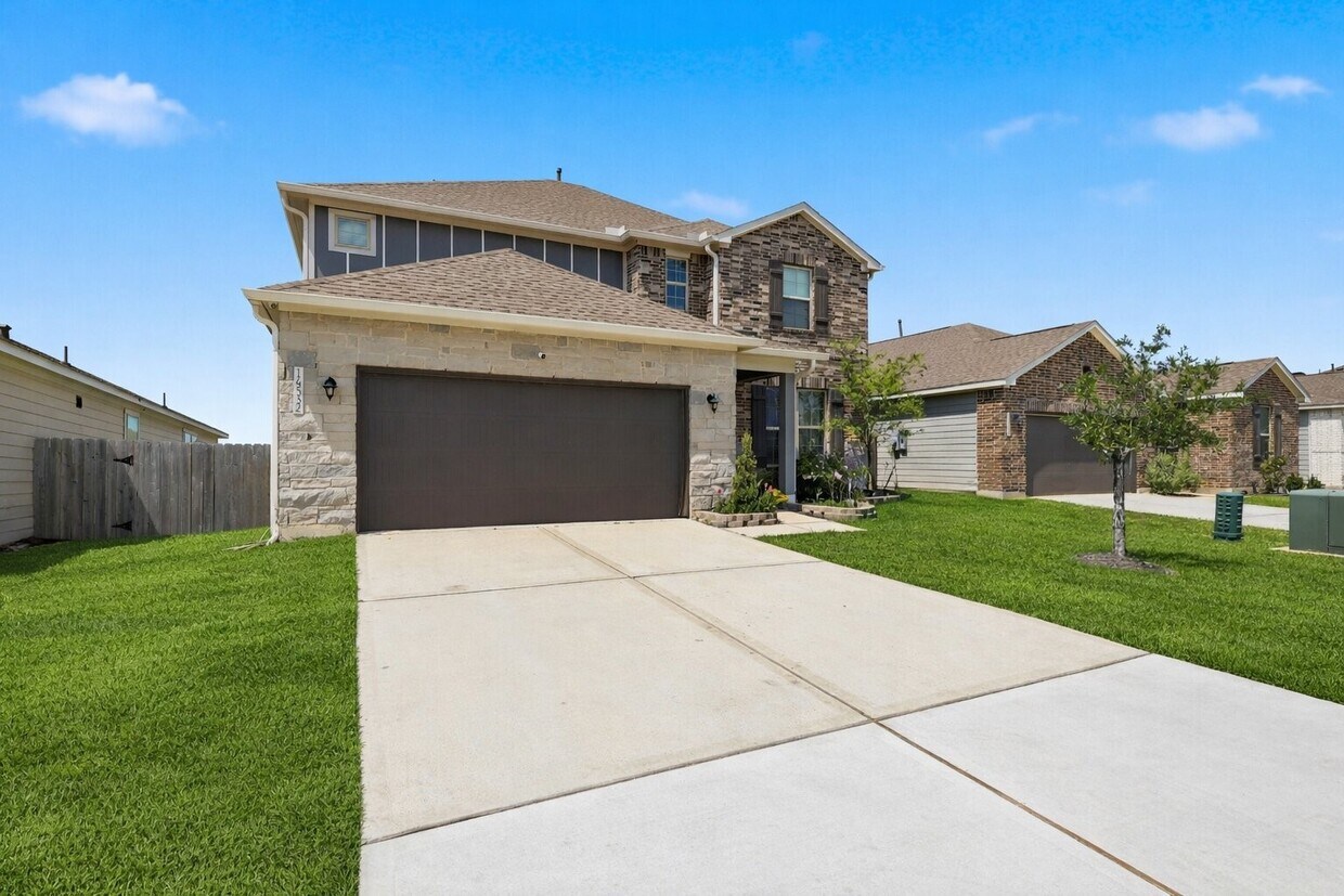
14532 Jelly Pnes Dr
Conroe, TX 77302
Today
|
Edit
Favorites
832-343-1913
-
Bedrooms
4
-
Bathrooms
3
-
Square Feet
2,641 sq ft
-
Available
Available Now
Highlights
- 2 Car Attached Garage
- Central Heating and Cooling System
14532 Jelly Pnes Dr

Favorites
About This Home
Available Now
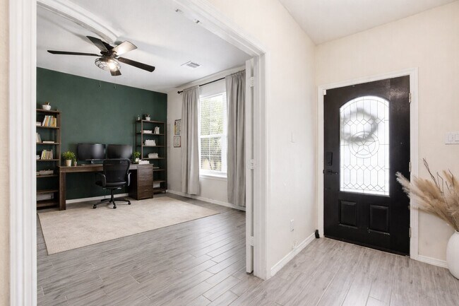
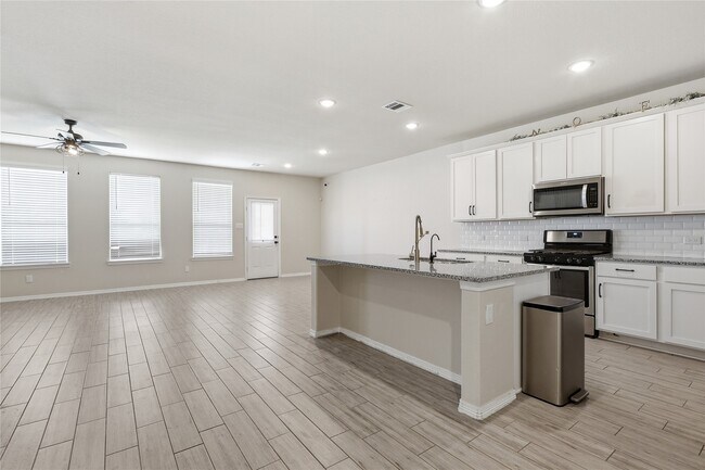
This Beautiful home featuring a downstairs study,granite countertops,and a spacious layout perfect for everyday living. Enjoy a large upstairs gameroom and a huge backyard ideal for entertaining,kids,or pets. Located in a family-friendly community with parks,splash pads,and a nearby school. Perfect for families—this one won’t last long! ??? MLS# 15303929
14532 Jelly Pnes Dr is a house located in Montgomery County and the 77302 ZIP Code. This area is served by the Conroe Independent School District attendance zone.
* Price shown is base rent. Excludes user-selected optional fees and variable or usage-based fees and required charges due at or prior to move-in or at move-out. Price, availability, fees, and any applicable rent special are subject to change without notice.
* Square footage definitions vary. Displayed square footage is approximate.
Home Details
Home Type
Single Family Detached Home
Year Built
Built in 2021
Bedrooms and Bathrooms
2.5 Bathrooms
4 Bedrooms
Interior Spaces
2,641 Sq Ft Home
2-Story Property
Kitchen
Gas Oven
Microwave
Dishwasher
Disposal
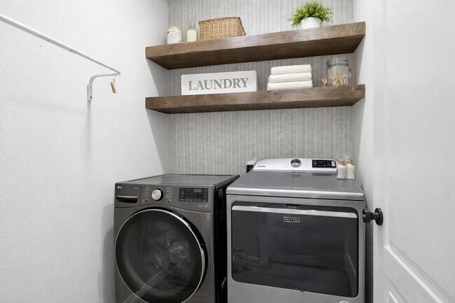
Laundry
Dryer
Washer
Listing and Financial Details
Property Available on 4/3/26
Long Term Lease
Parking
2 Car Attached Garage
Schools
Hope Elementary School
Moorhead Junior High School
Caney Creek High School
Utilities
Central Heating and Cooling System
Community Details
Overview
Granger Pines Subdivision
Pet Policy
Call for details about the types of pets allowed
Pet Deposit Required
Contact
- Listed by Kionna Sellers | JLA Realty
- Phone Number
- Contact
-
Source
 Houston Association of REALTORS®
Copyright © 2026 Houston Association of Realtors. All rights reserved. All information provided by the listing agent/broker is deemed reliable but is not guaranteed and should be independently verified.
Location
Get Directions
Called the “livable forest” for its abundant woods, Spring's Porter Heights/Woodbranch neighborhood sits midway between Houston and the expansive Sam Houston National Forest. The area features over 500 acres of parks and nature preserves, such as Peckinpaugh Preserve and Spring Creek Greenway Nature Center. Residents enjoy easy access to shopping centers like Valley Ranch Marketplace and a variety of dining options. The area is car-dependent, making major roadways like US-59 essential for commuting, with Downtown Houston just a 40-minute drive away. Lone Star College serves as a significant educational hub, contributing to the community's vibrant learning environment.
Many residents commute to nearby cities for work, taking advantage of the Houston Metro Park and Ride service to avoid rush-hour traffic. The neighborhood's history is rooted in its development as a master-planned community, maintaining its identity with annual events like the Mardi Gras Parade.
Learn more about living in Porter Heights/Woodbranch
Education
| Colleges & Universities | Distance | ||
|---|---|---|---|
| Colleges & Universities | Distance | ||
| Drive: | 23 min | 12.7 mi | |
| Drive: | 49 min | 38.1 mi | |
| Drive: | 52 min | 39.0 mi | |
| Drive: | 53 min | 40.5 mi |
14532 Jelly Pnes Dr is within 23 minutes or 12.7 miles from Lone Star College. It is also near San Jacinto College, North and Univ. of Houston, Downtown.
Schools

Public Middle School
Grades 6-8
1,391 Students
Nearby
Public High School
Grades 9-12
2,504 Students
Nearby
School data provided by
 The GreatSchools Rating helps parents compare schools within a state based on a variety of school quality indicators and provides a helpful picture of how effectively each school serves all of its students. Ratings are on a scale of 1 (below average) to 10 (above average) and can include test scores, college readiness, academic progress, advanced courses, equity, discipline and attendance data. We also advise parents to visit schools, consider other information on school performance and programs, and consider family needs as part of the school selection process.
View GreatSchools Rating Methodology
Data provided by GreatSchools.org © 2026. All rights reserved.
View GreatSchools Rating Methodology
Data provided by GreatSchools.org © 2026. All rights reserved.
Getting Around
 What do Walkability, Transit, Drivability, and Bikeability mean?
Walkability measures the walking distance to day-to-day needs.
Transit measures access to public transportation.
Drivability measures congestion, parking availability, and access to major roads.
Bikeability measures the suitability for cycling.
How It Works
What do Walkability, Transit, Drivability, and Bikeability mean?
Walkability measures the walking distance to day-to-day needs.
Transit measures access to public transportation.
Drivability measures congestion, parking availability, and access to major roads.
Bikeability measures the suitability for cycling.
How It Works
Somewhat Walkable
Walkability
20
/ 100
Exceptionally Drivable
Drivability
100
/ 100
Somewhat Bikeable
Bikeability
30
/ 100
Scores provided by
-
Soundscore™
-
/ 100
Traffic
-Airport
-Businesses
-Scores provided by
HowLoud What is a Sound Score Rating? A Sound Score Rating aggregates noise caused by vehicle traffic, airplane traffic and local sources. How It WorksYou May Also Like
Similar Rentals Nearby
-
-
4 Beds$2,895+Total Monthly PriceTotal Monthly Price NewPrices include base rent and required monthly fees. Variable costs based on usage may apply.2 Months Free
Pets Allowed Fitness Center Pool
-
-
-
-
-
 Total Monthly Price New4 Beds$1,980+Total Monthly PricePrices include base rent and required monthly fees of $130. Variable costs based on usage may apply.Base Rent:4 Beds$1,850+
 -
 Total Monthly Price New4 Beds$1,930+Total Monthly PricePrices include base rent and required monthly fees of $130. Variable costs based on usage may apply.Base Rent:4 Beds$1,800+
 -
 4 Beds$2,425Total Monthly PriceTotal Monthly Price NewPrices include all required monthly fees.House for Rent
 -
 4 Beds$2,165Total Monthly PriceTotal Monthly Price NewPrices include all required monthly fees.House for Rent


What Are Walk Score®, Transit Score®, and Bike Score® Ratings?
Walk Score® measures the walkability of any address. Transit Score® measures access to public transit. Bike Score® measures the bikeability of any address.
What is a Sound Score Rating?
A Sound Score Rating aggregates noise caused by vehicle traffic, airplane traffic and local sources.
14532 Jelly Pnes Dr
Conroe, TX 77302