
$2,300
/ Month
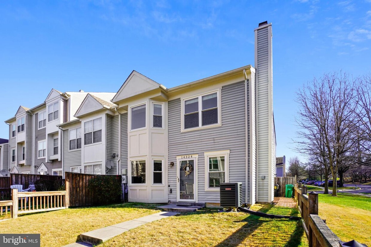
14324 S Shore Ct
Laurel, MD 20707
2 Weeks Ago
|
Edit
Favorites
14324 S Shore Ct

Favorites
Check Back Soon for Upcoming Availability
| Beds | Baths | Average SF |
|---|---|---|
| 2 Bedrooms 2 Bedrooms 2 Br | 1.5 Baths 1.5 Baths 1.5 Ba | 1,280 SF |
Fees and Policies
The fees below are based on community-supplied data and may exclude additional fees and utilities.
- Dogs Allowed
-
Fees not specified
- Cats Allowed
-
Fees not specified
About This Property
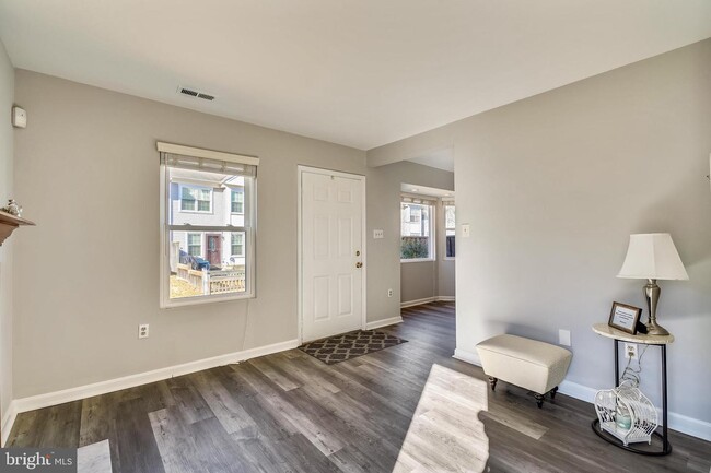
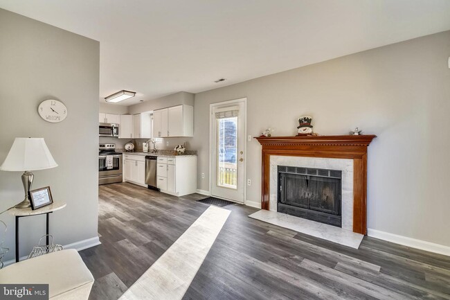
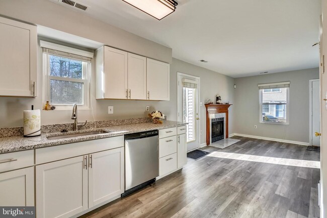
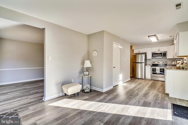
This two-level townhome boasts two spacious bedrooms—the primary features a walk-in closet and a versatile sitting area or home office. Enjoy the open living area complete with a cozy fireplace, a fenced front yard, dedicated parking, and convenient in-unit laundry.Ideal location- this home provides easy access to the Marc train and major highways such as I-95, Rt 29, and I-495. Nestled in a walkable neighborhood with ample visitor parking, this property is a must-see.
14324 S Shore Ct is a house located in Prince George's County and the 20707 ZIP Code. This area is served by the Prince George's County Public Schools attendance zone.
House Features
- Washer/Dryer
- Fireplace
- Walk-In Closets
- Playground
- Fenced Lot
Location
Get Directions
Located between Washington, D.C., and Baltimore, Laurel combines suburban living with easy access to major cities. The historic downtown area features a welcoming Main Street lined with independent businesses, while the Patuxent River winds through numerous parks and green spaces. The Laurel Lakes area offers outdoor recreation opportunities, and the Laurel Museum, housed in an 1840s mill workers' home, preserves the area's rich history. Housing options range from contemporary apartments near Towne Centre at Laurel to historic properties in the Old Town district. Current rental rates average $1,697 for one-bedroom units and $2,035 for two bedrooms, with year-over-year increases of 2.2% and 3.2% respectively.
Originally established as a mill town in the early 19th century, Laurel maintains strong connections to government and technology sectors, with NSA and Fort Meade located nearby.
Learn more about living in Laurel
Amenities
- Washer/Dryer
- Fireplace
- Walk-In Closets
- Fenced Lot
- Playground
Education
| Colleges & Universities | Distance | ||
|---|---|---|---|
| Colleges & Universities | Distance | ||
| Drive: | 19 min | 9.6 mi | |
| Drive: | 17 min | 9.8 mi | |
| Drive: | 23 min | 13.6 mi | |
| Drive: | 23 min | 14.2 mi |
14324 S Shore Ct is within 19 minutes or 9.6 miles from University of Maryland. It is also near Bowie State University and Howard Community College.
Schools


Public Elementary School
Grades PK-5
635 Students
Attendance Zone
Public Middle School
Grades 6-8
911 Students
Attendance Zone
Public High School
Grades 9-12
2,134 Students
Attendance Zone
Private Elementary & Middle School
Grades PK-8
156 Students
Nearby
Private Middle & High School
Grades 7-12
Nearby
School data provided by
 The GreatSchools Rating helps parents compare schools within a state based on a variety of school quality indicators and provides a helpful picture of how effectively each school serves all of its students. Ratings are on a scale of 1 (below average) to 10 (above average) and can include test scores, college readiness, academic progress, advanced courses, equity, discipline and attendance data. We also advise parents to visit schools, consider other information on school performance and programs, and consider family needs as part of the school selection process.
View GreatSchools Rating Methodology
Data provided by GreatSchools.org © 2025. All rights reserved.
View GreatSchools Rating Methodology
Data provided by GreatSchools.org © 2025. All rights reserved.
Transportation options available in Laurel include Greenbelt, Green/Yellow Line Center Platform, located 8.1 miles from 14324 S Shore Ct. 14324 S Shore Ct is near Baltimore/Washington International Thurgood Marshall, located 16.0 miles or 28 minutes away, and Ronald Reagan Washington Ntl, located 25.3 miles or 41 minutes away.
| Transit / Subway | Distance | ||
|---|---|---|---|
| Transit / Subway | Distance | ||
| Drive: | 14 min | 8.1 mi | |
| Drive: | 21 min | 9.8 mi | |
|
|
Drive: | 21 min | 10.6 mi |
| Drive: | 23 min | 11.3 mi | |
|
|
Drive: | 21 min | 12.9 mi |
| Commuter Rail | Distance | ||
|---|---|---|---|
| Commuter Rail | Distance | ||
|
|
Drive: | 5 min | 2.2 mi |
|
|
Drive: | 6 min | 3.1 mi |
|
|
Drive: | 9 min | 3.3 mi |
|
|
Drive: | 13 min | 5.5 mi |
|
|
Drive: | 14 min | 8.1 mi |
| Airports | Distance | ||
|---|---|---|---|
| Airports | Distance | ||
|
Baltimore/Washington International Thurgood Marshall
|
Drive: | 28 min | 16.0 mi |
|
Ronald Reagan Washington Ntl
|
Drive: | 41 min | 25.3 mi |
Time and distance from 14324 S Shore Ct.
| Shopping Centers | Distance | ||
|---|---|---|---|
| Shopping Centers | Distance | ||
| Walk: | 9 min | 0.5 mi | |
| Walk: | 14 min | 0.7 mi | |
| Walk: | 14 min | 0.8 mi |
14324 S Shore Ct has 3 shopping centers within 0.8 mile, which is about a 14-minute walk. The miles and minutes will be for the farthest away property.
| Parks and Recreation | Distance | ||
|---|---|---|---|
| Parks and Recreation | Distance | ||
|
Fairland Regional Park
|
Drive: | 9 min | 4.0 mi |
|
Patuxent Research Refuge - North Tract
|
Drive: | 16 min | 6.9 mi |
|
Patuxent Research Refuge - South Tract
|
Drive: | 15 min | 7.6 mi |
|
Maydale Conservation Park and Nature Center
|
Drive: | 16 min | 8.8 mi |
|
Browns Bridge Recreation Area
|
Drive: | 21 min | 10.4 mi |
14324 S Shore Ct has 5 parks within 10.4 miles, including Fairland Regional Park, Patuxent Research Refuge - North Tract, and Patuxent Research Refuge - South Tract.
| Hospitals | Distance | ||
|---|---|---|---|
| Hospitals | Distance | ||
| Drive: | 4 min | 1.5 mi | |
| Drive: | 14 min | 7.8 mi | |
| Drive: | 19 min | 10.8 mi |
14324 S Shore Ct has 3 hospitals within 10.8 miles, the nearest is Laurel Regional Medical Center which is 1.5 miles away and a 4 minute drive.
You May Also Like
Similar Rentals Nearby


What Are Walk Score®, Transit Score®, and Bike Score® Ratings?
Walk Score® measures the walkability of any address. Transit Score® measures access to public transit. Bike Score® measures the bikeability of any address.
What is a Sound Score Rating?
A Sound Score Rating aggregates noise caused by vehicle traffic, airplane traffic and local sources

14324 S Shore Ct
Laurel, MD 20707