$1,995
Total Monthly Price
12 Month Lease
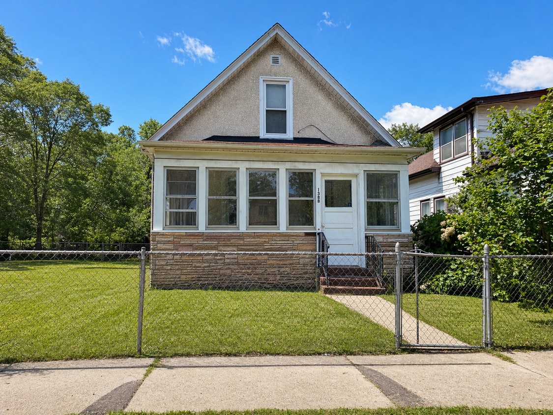
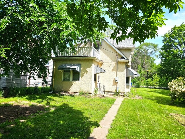
1388 7th St E
Saint Paul, MN 55106
Today
|
Edit
Favorites
952-206-8606
-
Bedrooms
2
-
Bathrooms
1
-
Square Feet
1,200 sq ft
-
Available
Available Jun 1
Highlights
- Hardwood Floors
- Yard
- Deck
1388 7th St E

Favorites
About This Home
12 Month Lease,
$1,995 deposit,
Available Jun 1
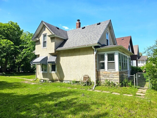
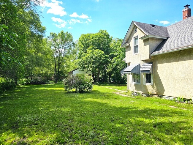
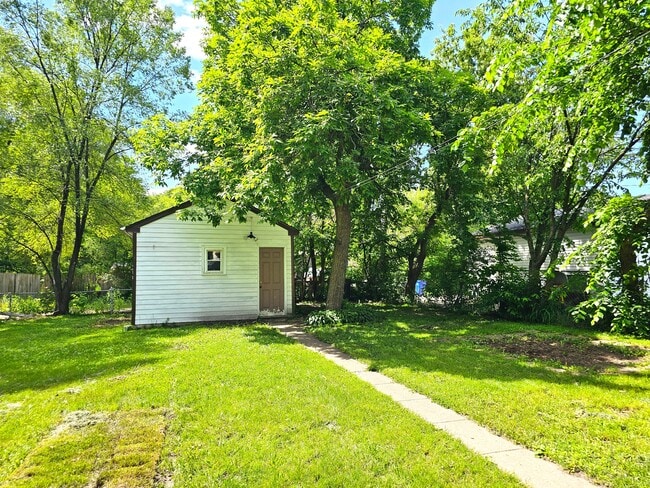
2-Story Home w/ Fenced Yard + Garage – Remodeled – Available June 1st Rare single-family rental on St. Paul’s East Side, more space, and a large fully fenced yard. Inside, the home has fully refinished hardwood floors throughout. The main level features a spacious eat-in kitchen plus a separate dining room with a bay window. Upstairs includes 2 bedrooms with good separation from the main living space. Additional features include a front porch and upper-level deck. Outside, enjoy a large fenced yard and a detached garage for parking and storage. Convenient location with quick access to shopping, parks, and transit, near French Immersion Elementary. Highlights: • Hardwood floors throughout • Large fenced yard (hard to find) • Detached garage + storage • Deck + 3-season porch • Single-family home Rental Details: • $1,999/month • Pet rent: $50/pet • Application fee: $40/adult • Minimum credit: 600 • Household income: $70,000
1388 7th St E is a house located in Ramsey County and the 55106 ZIP Code.
* Price shown is total price based on community-supplied monthly required fees. Excludes user-selected optional fees and variable or usage-based fees and required charges due at or prior to move-in or at move-out. Price, availability, fees, and any applicable rent special are subject to change without notice.
* Square footage definitions vary. Displayed square footage is approximate.
House Features
Hardwood Floors
Eat-in Kitchen
Dining Room
Bay Window
- Eat-in Kitchen
- Hardwood Floors
- Dining Room
- Bay Window
- Porch
- Deck
- Yard
Contact
- Phone Number
Location
Get Directions
Living in Saint Paul combines metropolitan energy with neighborhood charm in Minnesota's capital city. Situated along the Mississippi River's bluffs, the city offers an extensive parks system, including Como Park Zoo and Conservatory, which features botanical gardens and year-round exhibits. Housing options span from historic properties along Summit Avenue to contemporary apartments in Lowertown. Current rental data shows one-bedroom apartments average $1,261 per month, reflecting a 2.2% annual increase, while two-bedroom units typically rent for $1,611, up 2.2% from the previous year.
Each Saint Paul neighborhood has its own distinct character, from Cathedral Hill's Victorian mansions to Lowertown's converted warehouses. The city hosts several higher education institutions, including Macalester College and the University of St. Thomas. Saint Paul's legacy as a major river port and railroad hub remains evident in its preserved architecture and cultural attractions.
Learn more about living in Saint Paul
Education
| Colleges & Universities | Distance | ||
|---|---|---|---|
| Colleges & Universities | Distance | ||
| Drive: | 3 min | 1.9 mi | |
| Drive: | 8 min | 4.5 mi | |
| Drive: | 10 min | 6.5 mi | |
| Drive: | 13 min | 7.6 mi |
1388 7th St E is within 3 minutes or 1.9 miles from Metropolitan State University. It is also near Saint Paul College and Concordia Univ.-Saint Paul.
Transportation options available in Saint Paul include Union Depot Station, located 3.0 miles from 1388 7th St E. 1388 7th St E is near Minneapolis-St Paul International/Wold-Chamberlain, located 12.5 miles or 21 minutes away.
| Transit / Subway | Distance | ||
|---|---|---|---|
| Transit / Subway | Distance | ||
| Drive: | 6 min | 3.0 mi | |
| Drive: | 6 min | 3.1 mi | |
| Drive: | 7 min | 3.3 mi | |
| Drive: | 6 min | 3.4 mi | |
| Drive: | 6 min | 3.6 mi |
| Commuter Rail | Distance | ||
|---|---|---|---|
| Commuter Rail | Distance | ||
|
|
Drive: | 6 min | 3.0 mi |
|
|
Drive: | 23 min | 13.4 mi |
|
|
Drive: | 25 min | 17.6 mi |
|
|
Drive: | 35 min | 25.8 mi |
|
|
Drive: | 37 min | 27.4 mi |
| Airports | Distance | ||
|---|---|---|---|
| Airports | Distance | ||
|
Minneapolis-St Paul International/Wold-Chamberlain
|
Drive: | 21 min | 12.5 mi |
Getting Around
 What do Walkability, Transit, Drivability, and Bikeability mean?
Walkability measures the walking distance to day-to-day needs.
Transit measures access to public transportation.
Drivability measures congestion, parking availability, and access to major roads.
Bikeability measures the suitability for cycling.
How It Works
What do Walkability, Transit, Drivability, and Bikeability mean?
Walkability measures the walking distance to day-to-day needs.
Transit measures access to public transportation.
Drivability measures congestion, parking availability, and access to major roads.
Bikeability measures the suitability for cycling.
How It Works
Moderately Walkable
Walkability
60
/ 100
Some Public Transit
Transit
50
/ 100
Very Drivable
Drivability
80
/ 100
Moderately Bikeable
Bikeability
60
/ 100
Scores provided by
-
Soundscore™
-
/ 100
Traffic
-Airport
-Businesses
-Scores provided by
HowLoud What is a Sound Score Rating? A Sound Score Rating aggregates noise caused by vehicle traffic, airplane traffic and local sources. How It WorksTime and distance from 1388 7th St E.
| Shopping Centers | Distance | ||
|---|---|---|---|
| Shopping Centers | Distance | ||
| Walk: | 17 min | 0.9 mi | |
| Drive: | 2 min | 1.1 mi | |
| Drive: | 4 min | 1.8 mi |
1388 7th St E has 3 shopping centers within 1.8 miles, which is about a 4-minute drive. The miles and minutes will be for the farthest away property.
| Parks and Recreation | Distance | ||
|---|---|---|---|
| Parks and Recreation | Distance | ||
|
Phalen Park
|
Drive: | 4 min | 1.8 mi |
|
Phelan Regional Park
|
Drive: | 5 min | 2.1 mi |
|
Indian Mounds Park
|
Drive: | 5 min | 2.1 mi |
|
Keller Regional Park
|
Drive: | 6 min | 2.7 mi |
|
Arlington/Arkwright Park
|
Drive: | 7 min | 3.3 mi |
1388 7th St E has 5 parks within 3.3 miles, including Phalen Park, Indian Mounds Park, and Phelan Regional Park.
| Hospitals | Distance | ||
|---|---|---|---|
| Hospitals | Distance | ||
| Drive: | 6 min | 3.3 mi | |
| Drive: | 6 min | 3.5 mi | |
| Drive: | 6 min | 3.5 mi |
1388 7th St E has 3 hospitals within 3.5 miles, the nearest is Regions Hospital which is 3.3 miles away and a 6 minute drive.
| Military Bases | Distance | ||
|---|---|---|---|
| Military Bases | Distance | ||
| Drive: | 19 min | 11.2 mi |
1388 7th St E is 11.2 miles and a 19 minute drive from Fort Snelling Military Reservation.
Amenities
- Eat-in Kitchen
- Hardwood Floors
- Dining Room
- Bay Window
- Porch
- Deck
- Yard
1388 7th St E Photos
What Are Walk Score®, Transit Score®, and Bike Score® Ratings?
Walk Score® measures the walkability of any address. Transit Score® measures access to public transit. Bike Score® measures the bikeability of any address.
What is a Sound Score Rating?
A Sound Score Rating aggregates noise caused by vehicle traffic, airplane traffic and local sources.

1388 7th St E
Saint Paul, MN 55106