

$2,000
/ Month
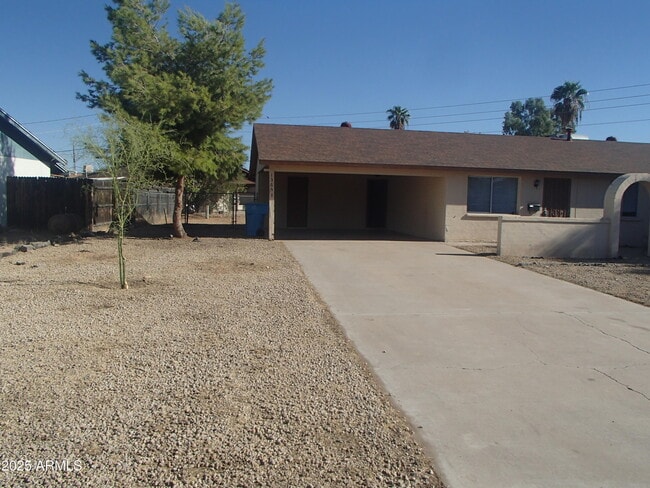
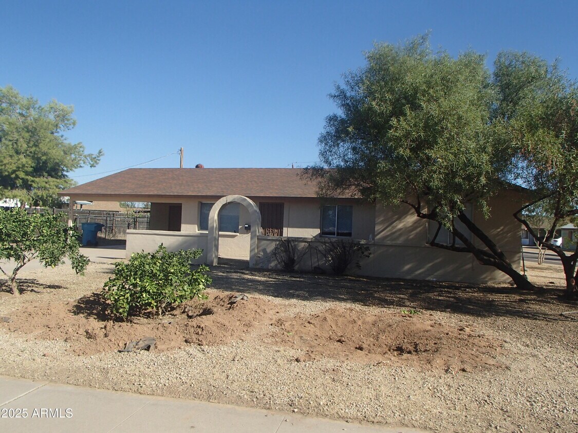
13631 N 35th St
Phoenix, AZ 85032
Today
Favorites
602-397-2243
-
Bedrooms
4
-
Bathrooms
1
-
Square Feet
1,624 sq ft
-
Available
Available Now
Highlights
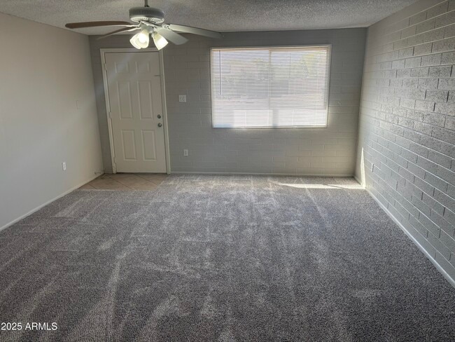
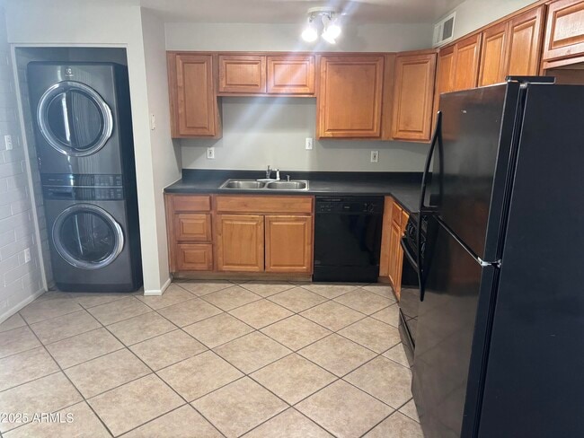
- Eat-In Kitchen
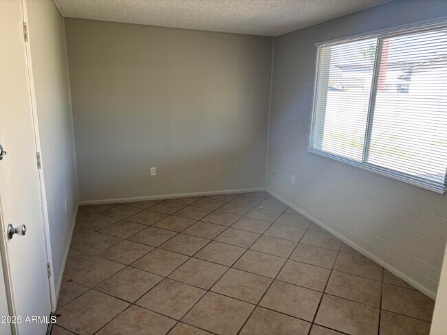
- Tile Flooring
- Central Air
- Carpet
- Stacked Washer and Dryer
- Heating Available
13631 N 35th St

Favorites
About This Home
$2,000 deposit,
Available Now
Completely Remodeled inside. Updated Carpet. New Paint. Updated Appliances. 4 Bedroom,2 bath plus den/ office and workshop too! Don't miss out on this fabulous home located on large corner lot.....approximately 100 yards to Indian Bend Elementary School...Move in ready! **$200 NON REFUNDABLE ADMINISTRATION FEE**
13631 N 35th St is a house located in Maricopa County and the 85032 ZIP Code. This area is served by the Paradise Valley Unified District attendance zone.
* Price shown is base rent. Excludes user-selected optional fees and variable or usage-based fees and required charges due at or prior to move-in or at move-out. Price, availability, fees, and any applicable rent special are subject to change without notice.
* Square footage definitions vary. Displayed square footage is approximate.
Home Details
Year Built
Built in 1970
Bedrooms and Bathrooms
1 Bathroom
4 Bedrooms
Flooring
Tile
Carpet
Home Design
Block Exterior
Composition Roof
Interior Spaces
1,624 Sq Ft Home
1-Story Property
Kitchen
Eat-In Kitchen
Laundry
Stacked Washer and Dryer
Listing and Financial Details
Property Available on 10/21/25
$200 Move-In Fee
12-Month Minimum Lease Term
Tax Lot 260
Assessor Parcel Number 214-61-470
Lot Details
0.25 Acre Lot
Desert faces the back of the property
Chain Link Fence
Parking
2 Carport Spaces
Schools
Indian Bend Elementary School
Greenway Middle School
Paradise Valley High School
Utilities
Central Air
Heating Available
Community Details
Overview
No Home Owners Association
Built by John F Long
Paradise Valley Oasis No 2 A East Subdivision
Contact
- Listed by Vernon Stevens | RE/MAX Professionals
- Phone Number
- Contact
-
Source
Arizona Regional MLS
Copyright 2025 Arizona Regional MLS. All rights reserved. Information is deemed reliable but not guaranteed.
Location
Get Directions
Nestled in the heart of the Scottsdale-Phoenix area, Paradise Valley North is a peaceful desert oasis surrounded by mountains—Camelback Mountain lies to the south, Phoenix Mountain Preserve to the west, and McDowell Mountains to the east. Paradise Valley North is located in Maricopa County and is recognized for its deluxe golfing, luxury shopping centers, and ultra-posh restaurants. It’s a major tourism spot and has eight full-service resorts.
Paradise Valley North’s terrain is largely made up by Mummy Mountain. This community’s locale gives residents direct access to Camelback Mountain and Piestewa Peak. Paradise Valley North residents also have access to numerous parks like Roadrunner Park, Buffalo Ridge Park, and Paradise Valley Park. A bevy of golf and country clubs offer additional options for outdoor activities as well.
Retail delights abound at the Paradise Valley Mall as well as nearby Bell Towne Plaza and Desert Ridge Marketplace.
Learn more about living in Paradise Valley North
Education
| Colleges & Universities | Distance | ||
|---|---|---|---|
| Colleges & Universities | Distance | ||
| Drive: | 8 min | 3.5 mi | |
| Drive: | 16 min | 8.1 mi | |
| Drive: | 17 min | 8.2 mi | |
| Drive: | 21 min | 10.6 mi |
13631 N 35th St is within 8 minutes or 3.5 miles from Paradise Valley Comm. Coll.. It is also near DeVry University, Arizona and Argosy University.
Schools


Public Elementary School
Grades PK-6
566 Students
Attendance Zone
Public Elementary & Middle School
Grades 5-8
511 Students
Attendance Zone
Public Middle & High School
Grades 8-12
1,109 Students
Attendance Zone
Private Elementary School
Grades PK-1
Nearby
Private Elementary School
Grades PK-K
52 Students
Nearby
Private Elementary, Middle & High School
Grades PK-12
818 Students
Nearby
Private High School
Grades 9-12
Nearby
School data provided by
 The GreatSchools Rating helps parents compare schools within a state based on a variety of school quality indicators and provides a helpful picture of how effectively each school serves all of its students. Ratings are on a scale of 1 (below average) to 10 (above average) and can include test scores, college readiness, academic progress, advanced courses, equity, discipline and attendance data. We also advise parents to visit schools, consider other information on school performance and programs, and consider family needs as part of the school selection process.
View GreatSchools Rating Methodology
Data provided by GreatSchools.org © 2025. All rights reserved.
View GreatSchools Rating Methodology
Data provided by GreatSchools.org © 2025. All rights reserved.
Transportation options available in Phoenix include 19Th Ave/Dunlap, located 7.6 miles from 13631 N 35th St. 13631 N 35th St is near Phoenix Sky Harbor International, located 15.9 miles or 24 minutes away, and Phoenix-Mesa Gateway, located 42.7 miles or 56 minutes away.
| Transit / Subway | Distance | ||
|---|---|---|---|
| Transit / Subway | Distance | ||
|
|
Drive: | 16 min | 7.6 mi |
|
|
Drive: | 16 min | 8.1 mi |
|
|
Drive: | 15 min | 9.1 mi |
|
|
Drive: | 19 min | 9.3 mi |
|
|
Drive: | 19 min | 9.4 mi |
| Airports | Distance | ||
|---|---|---|---|
| Airports | Distance | ||
|
Phoenix Sky Harbor International
|
Drive: | 24 min | 15.9 mi |
|
Phoenix-Mesa Gateway
|
Drive: | 56 min | 42.7 mi |
Time and distance from 13631 N 35th St.
| Shopping Centers | Distance | ||
|---|---|---|---|
| Shopping Centers | Distance | ||
| Walk: | 12 min | 0.7 mi | |
| Walk: | 13 min | 0.7 mi | |
| Walk: | 14 min | 0.7 mi |
13631 N 35th St has 3 shopping centers within 0.7 mile, which is about a 14-minute walk. The miles and minutes will be for the farthest away property.
| Parks and Recreation | Distance | ||
|---|---|---|---|
| Parks and Recreation | Distance | ||
|
Venturoso Park
|
Drive: | 3 min | 1.5 mi |
|
Lookout Mountain Park
|
Drive: | 9 min | 3.7 mi |
|
Grovers Basin
|
Drive: | 8 min | 4.3 mi |
|
Dreamy Draw Recreation Area
|
Drive: | 6 min | 4.5 mi |
|
Arizona Horse Lover's Park
|
Drive: | 9 min | 5.0 mi |
13631 N 35th St has 5 parks within 5.0 miles, including Venturoso Park, Lookout Mountain Park, and Grovers Basin.
| Hospitals | Distance | ||
|---|---|---|---|
| Hospitals | Distance | ||
| Drive: | 5 min | 2.4 mi | |
| Drive: | 11 min | 5.7 mi | |
| Drive: | 11 min | 7.1 mi |
13631 N 35th St has 3 hospitals within 7.1 miles, the nearest is Abrazo Scottsdale Campus which is 2.4 miles away and a 5 minute drive.
| Military Bases | Distance | ||
|---|---|---|---|
| Military Bases | Distance | ||
| Drive: | 24 min | 15.8 mi | |
| Drive: | 42 min | 31.9 mi | |
| Drive: | 113 min | 87.3 mi |
13631 N 35th St has 3 military bases within 87.3 miles, the nearest is Phoenix Sky Harbor Airport Air Guard Station which is 15.8 miles away and a 24 minute drive.
You May Also Like
Similar Rentals Nearby


What Are Walk Score®, Transit Score®, and Bike Score® Ratings?
Walk Score® measures the walkability of any address. Transit Score® measures access to public transit. Bike Score® measures the bikeability of any address.
What is a Sound Score Rating?
A Sound Score Rating aggregates noise caused by vehicle traffic, airplane traffic and local sources
13631 N 35th St
Phoenix, AZ 85032