
Vision on Wilshire
6245 Wilshire Blvd,
Los Angeles, CA 90048
$3,094 - $12,849
Studio - 3 Beds
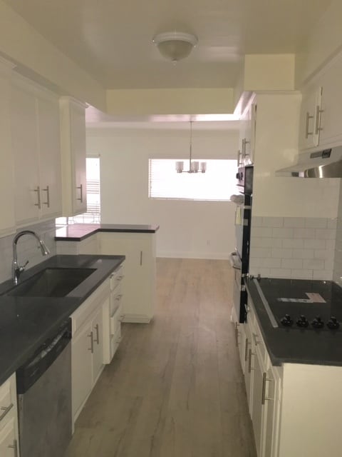
Beverly Hills Controlled Access NEW REMODELED UNIT All new Kitchen & Bathrooms Tile & Marble Countertops All new stainless steel appliances Recess Lighting First floor/rear apt Large bright living room Separate Dining area Wood Floors throughout Central A/C Large Closet Space Pool Garage parking- one space Laundry on Site
133 N Swall Dr is an apartment community located in Los Angeles County and the 90211 ZIP Code. This area is served by the Beverly Hills Unified School District attendance zone.
Unique Features
Air Conditioning
Dishwasher
High Speed Internet Access
Hardwood Floors
Beverly Hills, spanning just 5.71 square miles, combines elegant residential areas with world-class shopping and dining. Tree-lined streets and well-maintained green spaces like Beverly Gardens Park along Santa Monica Boulevard create an inviting atmosphere. The Golden Triangle shopping district, home to the renowned Rodeo Drive, offers high-end retail experiences. Housing options range from estates in Trousdale Estates to apartments south of Wilshire Boulevard, where one-bedroom apartments currently average $2,728 with a 1.1% increase year-over-year.
The city celebrates arts and culture through venues like the Wallis Annenberg Center for the Performing Arts and the historic Greystone Mansion. Landmarks such as the Beverly Hills Hotel and Beverly Wilshire Hotel contribute to the area's distinctive character. Notable areas include the residential streets north of Santa Monica Boulevard and the South Beverly Drive district, with its local shops and eateries.
Learn more about living in Beverly Hills| Colleges & Universities | Distance | ||
|---|---|---|---|
| Colleges & Universities | Distance | ||
| Drive: | 10 min | 4.3 mi | |
| Drive: | 10 min | 5.1 mi | |
| Drive: | 14 min | 5.4 mi | |
| Drive: | 11 min | 5.5 mi |


Transportation options available in Beverly Hills include Culver City, located 3.2 miles from 133 N Swall Dr. 133 N Swall Dr is near Los Angeles International, located 11.0 miles or 21 minutes away, and Bob Hope, located 13.4 miles or 26 minutes away.
| Transit / Subway | Distance | ||
|---|---|---|---|
| Transit / Subway | Distance | ||
|
|
Drive: | 8 min | 3.2 mi |
|
|
Drive: | 8 min | 3.7 mi |
|
|
Drive: | 8 min | 3.9 mi |
|
|
Drive: | 10 min | 4.0 mi |
|
|
Drive: | 9 min | 4.7 mi |
| Commuter Rail | Distance | ||
|---|---|---|---|
| Commuter Rail | Distance | ||
|
|
Drive: | 19 min | 10.6 mi |
|
|
Drive: | 21 min | 10.9 mi |
|
|
Drive: | 23 min | 11.3 mi |
|
|
Drive: | 21 min | 11.6 mi |
|
|
Drive: | 25 min | 12.3 mi |
| Airports | Distance | ||
|---|---|---|---|
| Airports | Distance | ||
|
Los Angeles International
|
Drive: | 21 min | 11.0 mi |
|
Bob Hope
|
Drive: | 26 min | 13.4 mi |
Scores provided by
Traffic
-Airport
-Businesses
-Scores provided by
HowLoud What is a Sound Score Rating? A Sound Score Rating aggregates noise caused by vehicle traffic, airplane traffic and local sources. How It WorksTime and distance from 133 N Swall Dr.
| Shopping Centers | Distance | ||
|---|---|---|---|
| Shopping Centers | Distance | ||
| Walk: | 13 min | 0.7 mi | |
| Walk: | 14 min | 0.7 mi | |
| Walk: | 14 min | 0.8 mi |
| Parks and Recreation | Distance | ||
|---|---|---|---|
| Parks and Recreation | Distance | ||
|
Zimmer Children's Museum
|
Drive: | 3 min | 1.3 mi |
|
La Brea Tar Pits
|
Drive: | 4 min | 2.0 mi |
|
Virginia Robinson Gardens
|
Drive: | 7 min | 2.6 mi |
|
Mathias Botanical Garden
|
Drive: | 9 min | 3.8 mi |
|
Runyon Canyon
|
Drive: | 11 min | 4.5 mi |
| Hospitals | Distance | ||
|---|---|---|---|
| Hospitals | Distance | ||
| Walk: | 16 min | 0.8 mi | |
| Drive: | 3 min | 1.7 mi | |
| Drive: | 4 min | 1.9 mi |
| Military Bases | Distance | ||
|---|---|---|---|
| Military Bases | Distance | ||
| Drive: | 21 min | 12.6 mi | |
| Drive: | 42 min | 30.5 mi | |
| Drive: | 45 min | 32.8 mi |
Pets Allowed Fitness Center Pool Maintenance on site High-Speed Internet Controlled Access EV Charging
Pets Allowed In Unit Washer & Dryer Maintenance on site Heat Controlled Access Elevator
What Are Walk Score®, Transit Score®, and Bike Score® Ratings?
Walk Score® measures the walkability of any address. Transit Score® measures access to public transit. Bike Score® measures the bikeability of any address.
What is a Sound Score Rating?
A Sound Score Rating aggregates noise caused by vehicle traffic, airplane traffic and local sources.

133 N Swall Dr
Beverly Hills, CA 90211


