
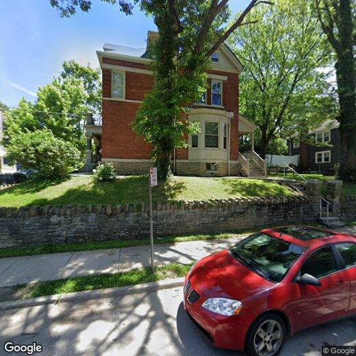
131 W Nixon St
Cincinnati, OH 45220
-
Bedrooms
6
-
Bathrooms
2
-
Square Feet
2,695 sq ft
-
Available
Available Now

About This Home
Apartments for Rent Near UC Medical Center and Burnet Woods Park – Pet Friendly, Prime Clifton Location This classic apartment community offers a convenient location near the University of Cincinnati Medical Center (East Campus) and Burnet Woods Park, placing you in the heart of Clifton with easy access to everything the neighborhood has to offer. Inside, you'll find features such as Balcony/Patio, Carpet, Hardwood Flooring, Luxury Vinyl Planks, with more amenities designed for your comfort.
131 W Nixon St is a house located in Hamilton County and the 45220 ZIP Code.
Fees and Policies
The fees listed below are community-provided and may exclude utilities or add-ons. All payments are made directly to the property and are non-refundable unless otherwise specified. Use the Cost Calculator to determine costs based on your needs.
-
One-Time Basics
-
Security Deposit - Refundable$2,995
-
Property Fee Disclaimer: Based on community-supplied data and independent market research. Subject to change without notice. May exclude fees for mandatory or optional services and usage-based utilities.
Contact
- Phone Number
- Website View Property Website
- Contact
-
Source

In Clifton there’s plenty to do and see. The rolling hills, lush parks and green spaces, hip shopping, and affordable apartments create a vibrancy in Clifton that can’t be ignored.
In addition to its active art scene, the neighborhood is encompassing of Mount Storm Park, Edgewood Grove Park, and the Cincinnati State Technical and Community College. Locals enjoy the direct access to Interstate 75, making commutes in and around the city a breeze.
Clifton is just north of the 90-acre Burnet Woods Park and the University of Cincinnati campus. When you have a craving for something sweet or savory, head on over to the Clifton Gaslight District for every kind of cuisine imaginable. Clifton sits atop a hill overlooking the Northside, and Ludlow Avenue has been dubbed Cincinnati’s first “Main Street.
Learn more about living in Clifton| Colleges & Universities | Distance | ||
|---|---|---|---|
| Colleges & Universities | Distance | ||
| Walk: | 7 min | 0.4 mi | |
| Walk: | 11 min | 0.6 mi | |
| Drive: | 8 min | 2.8 mi | |
| Drive: | 9 min | 2.9 mi |
Transportation options available in Cincinnati include Findlay Market-Race Station - Race & Elder, located 2.0 miles from 131 W Nixon St. 131 W Nixon St is near Cincinnati/Northern Kentucky International, located 18.1 miles or 33 minutes away.
| Transit / Subway | Distance | ||
|---|---|---|---|
| Transit / Subway | Distance | ||
| Drive: | 5 min | 2.0 mi | |
| Drive: | 5 min | 2.1 mi | |
| Drive: | 6 min | 2.1 mi | |
| Drive: | 6 min | 2.2 mi | |
| Drive: | 7 min | 2.5 mi |
| Commuter Rail | Distance | ||
|---|---|---|---|
| Commuter Rail | Distance | ||
|
|
Drive: | 8 min | 4.1 mi |
| Airports | Distance | ||
|---|---|---|---|
| Airports | Distance | ||
|
Cincinnati/Northern Kentucky International
|
Drive: | 33 min | 18.1 mi |
Scores provided by
Traffic
-Airport
-Businesses
-Scores provided by
HowLoud What is a Sound Score Rating? A Sound Score Rating aggregates noise caused by vehicle traffic, airplane traffic and local sources. How It WorksTime and distance from 131 W Nixon St.
| Shopping Centers | Distance | ||
|---|---|---|---|
| Shopping Centers | Distance | ||
| Drive: | 3 min | 1.5 mi | |
| Drive: | 4 min | 1.7 mi | |
| Drive: | 5 min | 2.4 mi |
| Parks and Recreation | Distance | ||
|---|---|---|---|
| Parks and Recreation | Distance | ||
|
Burnet Woods
|
Walk: | 5 min | 0.3 mi |
|
Trailside Nature Center
|
Walk: | 6 min | 0.4 mi |
|
Cincinnati Zoo and Botanical Garden
|
Walk: | 9 min | 0.5 mi |
|
William H. Taft National Historic Site
|
Drive: | 5 min | 1.7 mi |
|
Eden Park
|
Drive: | 7 min | 3.1 mi |
| Hospitals | Distance | ||
|---|---|---|---|
| Hospitals | Distance | ||
| Walk: | 14 min | 0.7 mi | |
| Walk: | 16 min | 0.8 mi | |
| Drive: | 3 min | 1.3 mi |
| Military Bases | Distance | ||
|---|---|---|---|
| Military Bases | Distance | ||
| Drive: | 68 min | 51.3 mi | |
| Drive: | 74 min | 56.4 mi | |
| Drive: | 76 min | 59.6 mi |
You May Also Like
131 W Nixon St
Cincinnati, OH 45220