$2,195
/ Month
1249 33rd St
Sacramento, CA 95816
Today
Favorites
415-342-4220
-
Bedrooms
2
-
Bathrooms
1
-
Square Feet
1,600 sq ft
-
Available
Available Nov 1
1249 33rd St

Favorites
About This Home
$2,195 deposit,
Available Nov 1
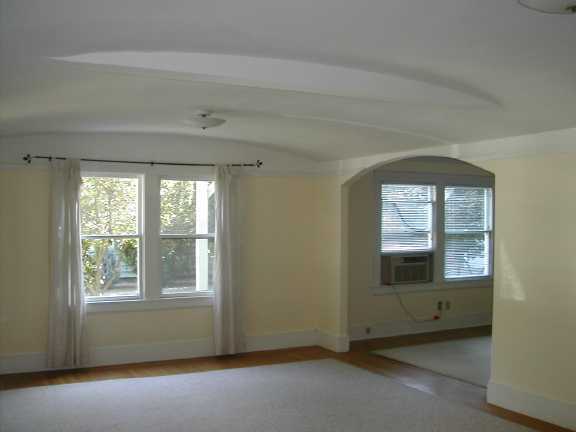
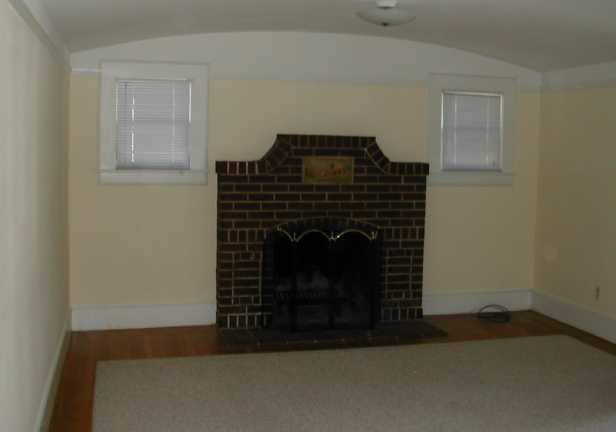
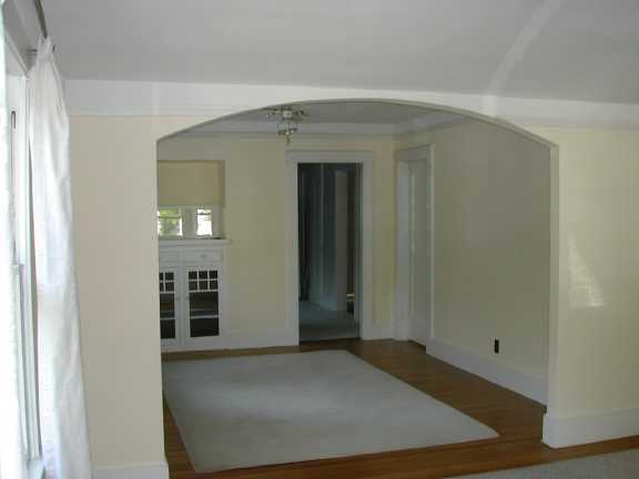
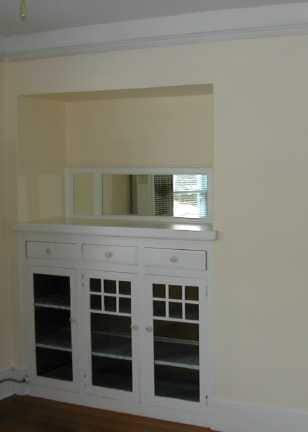
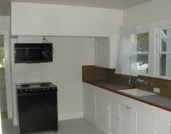
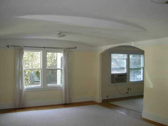
This is a very large unit (1600 SF) is in a prime East Sac location. It is the first floor of a two-story 1920s vintage building. It has a great floor plan with hardwood floors, a large living room with fireplace, spacious dining room with built in hutch, a light bright tiled kitchen, separate laundry room with new washer and dryer, and two generous bedrooms with a bathroom in between. There is lots of storage. The house is walking distance to Starbuck's, cleaners, the Alhambra Safeway and other stores. There is good street parking, and gardening service is included. We have a strict low-noise policy so and are looking for people who will benefit from that and contribute to it, as there is another unit on the second floor, above this one. 6 or 12 month lease. Tenant pays all utilities including one half of the city water/sewer charge; that half is currently running at about $115/mo. No smokers; indoor cats ok with deposit. We require excellent credit history. The address is 1249 33rd St, one block north of Folsom Blvd.
1249 33rd St is a townhome located in Sacramento County and the 95816 ZIP Code. This area is served by the Sacramento City Unified attendance zone.
* Price shown is base rent. Excludes user-selected optional fees and variable or usage-based fees and required charges due at or prior to move-in or at move-out. Price, availability, fees, and any applicable rent special are subject to change without notice.
* Square footage definitions vary. Displayed square footage is approximate.
Contact
- Listed by Bruce
- Phone Number
- Contact
Location
Get Directions
East Sacramento offers renters a breath of fresh air in the city. Known for tree-lined streets and great parks, East Sacramento is one of the city’s best neighborhoods. The community features lavish apartments, condos, townhomes, and houses. Join your new friends and neighbors at popular McKinley Park, known for its elegant rose garden, food trucks, festivals, concerts, and outdoor movie nights. The neighborhood is also known for its stellar dining and nightlife scene. While living in East Sacramento, you’ll have easy access to craft breweries, trendy coffee shops, quaint boutiques, sports bars, and diverse eateries. Great for students as well, the community borders California State University, Sacramento. This vibrant neighborhood also offers close proximity to Midtown and Downtown Sacramento, which are both about four miles away.
Learn more about living in East Sacramento
Education
| Colleges & Universities | Distance | ||
|---|---|---|---|
| Colleges & Universities | Distance | ||
| Drive: | 6 min | 2.9 mi | |
| Drive: | 6 min | 3.4 mi | |
| Drive: | 16 min | 10.1 mi | |
| Drive: | 16 min | 10.2 mi |
1249 33rd St is within 6 minutes or 2.9 miles from Sacramento State. It is also near Sacramento City College and Cosumnes River College.
Schools


Public Elementary School
Grades K-6
449 Students
Attendance Zone
Public Elementary School
Grades K-3
372 Students
Nearby
Public Middle School
Grades 7-8
1,075 Students
Attendance Zone
Public High School
Grades 9-12
1,733 Students
Attendance Zone
Private Elementary & Middle School
Grades PK-8
304 Students
Nearby
Private Elementary & Middle School
Grades PK-8
46 Students
Nearby
Private Middle & High School
Grades 7-12
Nearby
School data provided by
 The GreatSchools Rating helps parents compare schools within a state based on a variety of school quality indicators and provides a helpful picture of how effectively each school serves all of its students. Ratings are on a scale of 1 (below average) to 10 (above average) and can include test scores, college readiness, academic progress, advanced courses, equity, discipline and attendance data. We also advise parents to visit schools, consider other information on school performance and programs, and consider family needs as part of the school selection process.
View GreatSchools Rating Methodology
Data provided by GreatSchools.org © 2025. All rights reserved.
View GreatSchools Rating Methodology
Data provided by GreatSchools.org © 2025. All rights reserved.
Transportation options available in Sacramento include 29Th Street, located 0.8 mile from 1249 33rd St. 1249 33rd St is near Sacramento International, located 13.4 miles or 21 minutes away.
| Transit / Subway | Distance | ||
|---|---|---|---|
| Transit / Subway | Distance | ||
|
|
Walk: | 14 min | 0.8 mi |
|
|
Walk: | 17 min | 0.9 mi |
|
|
Drive: | 3 min | 1.4 mi |
|
|
Drive: | 3 min | 1.4 mi |
|
|
Drive: | 4 min | 2.0 mi |
| Commuter Rail | Distance | ||
|---|---|---|---|
| Commuter Rail | Distance | ||
| Drive: | 6 min | 2.8 mi | |
|
|
Drive: | 21 min | 16.6 mi |
|
|
Drive: | 26 min | 18.7 mi |
|
|
Drive: | 26 min | 20.9 mi |
|
|
Drive: | 40 min | 33.1 mi |
| Airports | Distance | ||
|---|---|---|---|
| Airports | Distance | ||
|
Sacramento International
|
Drive: | 21 min | 13.4 mi |
Time and distance from 1249 33rd St.
| Shopping Centers | Distance | ||
|---|---|---|---|
| Shopping Centers | Distance | ||
| Walk: | 5 min | 0.3 mi | |
| Walk: | 10 min | 0.5 mi | |
| Walk: | 14 min | 0.8 mi |
1249 33rd St has 3 shopping centers within 0.8 mile, which is about a 14-minute walk. The miles and minutes will be for the farthest away property.
| Parks and Recreation | Distance | ||
|---|---|---|---|
| Parks and Recreation | Distance | ||
|
Sutter's Fort State Historical Monument
|
Walk: | 12 min | 0.6 mi |
|
Governor's Mansion State Historic Park
|
Drive: | 4 min | 2.0 mi |
|
California State Capitol Museum
|
Drive: | 4 min | 2.2 mi |
|
Leland Stanford Mansion State Historic Park
|
Drive: | 5 min | 2.2 mi |
|
Paradise Beach County Recreation Area
|
Drive: | 5 min | 2.5 mi |
1249 33rd St has 5 parks within 2.5 miles, including Sutter's Fort State Historical Monument, Leland Stanford Mansion State Historic Park, and California State Capitol Museum.
| Hospitals | Distance | ||
|---|---|---|---|
| Hospitals | Distance | ||
| Walk: | 9 min | 0.5 mi | |
| Walk: | 13 min | 0.7 mi | |
| Drive: | 3 min | 1.2 mi |
1249 33rd St has 3 hospitals within 1.2 miles, the nearest is Sutter Medical Center, Sacramento which is 0.5 mile away and a 9 minute walk.
| Military Bases | Distance | ||
|---|---|---|---|
| Military Bases | Distance | ||
| Drive: | 24 min | 11.0 mi |
1249 33rd St is 11.0 miles and a 24 minute drive from McClellan Air Force Base.
You May Also Like
Similar Rentals Nearby


What Are Walk Score®, Transit Score®, and Bike Score® Ratings?
Walk Score® measures the walkability of any address. Transit Score® measures access to public transit. Bike Score® measures the bikeability of any address.
What is a Sound Score Rating?
A Sound Score Rating aggregates noise caused by vehicle traffic, airplane traffic and local sources
1249 33rd St
Sacramento, CA 95816