1245b E Maryland Ave
1245b E Maryland Ave
Phoenix, AZ 85014
2 Weeks Ago
|
Edit
Favorites
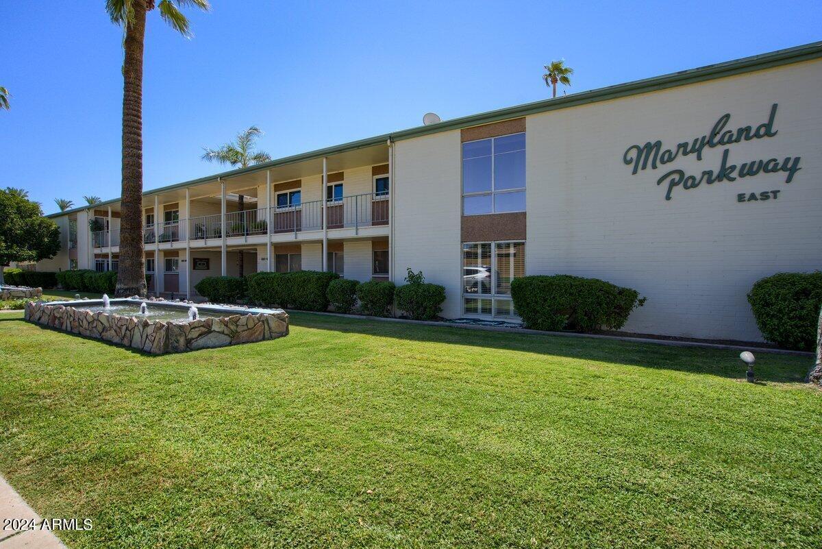
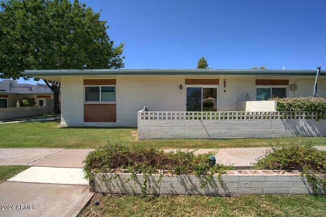
1245b E Maryland Ave

Favorites
Check Back Soon for Upcoming Availability
| Beds | Baths | Average SF |
|---|---|---|
| 2 Bedrooms 2 Bedrooms 2 Br | 2 Baths 2 Baths 2 Ba | — |
About This Property
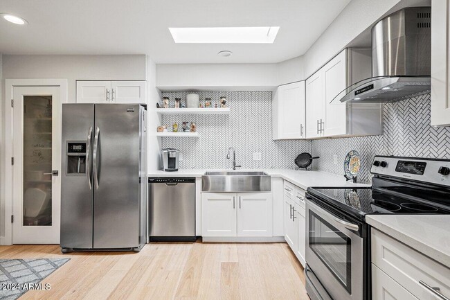
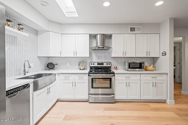
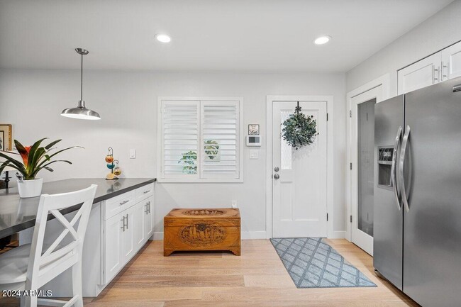
Beautifully updated 2 Bedroom/ 2 Bath Located and the Renowned Maryland Parkway East. Stainless appliances,quartz counters,waterfall pennisula. Gorgeous amenities including recreation room,large grassy areas,workout facility,newer state of art event room and beautiful large pool. Unit includes its own private laundry and storage areas.
1245B E Maryland Ave is a house located in Maricopa County and the 85014 ZIP Code. This area is served by the Madison Elementary District attendance zone.
Location
Get Directions
North Phoenix refers to the vast swath of land that stretches from Bethany Home Road up towards the Phoenix mountains. Bounded to the east by State Route 51 and to the west by 51st Avenue, North Phoenix is home a slew of diverse communities and neighborhoods all offering a variety of rentals ranging from the upscale to the more affordable. There are numerous golf courses and of course the mountains that offer residents a number of outdoor activities to engage in. For shopping and dining, residents head to Desert Ridge Marketplace on High Street, which is filled with upscale boutiques, nightlife hotspots, restaurants, and more. Interstate 17 and Route 101 make commuting around this desirable area simple.
Learn more about living in North PhoenixBelow are rent ranges for similar nearby apartments
| Beds | Average Size | Lowest | Typical | Premium |
|---|---|---|---|---|
| Studio Studio Studio | 565 Sq Ft | $775 | $1,433 | $4,716 |
| 1 Bed 1 Bed 1 Bed | 738-739 Sq Ft | $650 | $1,372 | $20,125 |
| 2 Beds 2 Beds 2 Beds | 1130-1131 Sq Ft | $800 | $1,812 | $6,500 |
| 3 Beds 3 Beds 3 Beds | 1673 Sq Ft | $1,235 | $2,355 | $6,303 |
| 4 Beds 4 Beds 4 Beds | 1949 Sq Ft | $1,199 | $2,809 | $7,700 |
Education
| Colleges & Universities | Distance | ||
|---|---|---|---|
| Colleges & Universities | Distance | ||
| Drive: | 11 min | 5.0 mi | |
| Drive: | 11 min | 5.4 mi | |
| Drive: | 13 min | 5.4 mi | |
| Drive: | 12 min | 5.5 mi |
1245b E Maryland Ave is within 11 minutes or 5.0 miles from Phoenix College. It is also near DeVry University, Arizona and Argosy University.
Schools


Public Elementary & Middle School
Grades 5-8
913 Students
Attendance Zone
Public Elementary School
Grades PK-4
733 Students
Attendance Zone
Public High School
Grades 9-12
2,135 Students
Attendance Zone
Private Elementary & Middle School
Grades K-8
159 Students
Nearby
Private Elementary & Middle School
Grades PK-7
Nearby
Private High School
Grades 9-12
39 Students
Nearby
School data provided by
 The GreatSchools Rating helps parents compare schools within a state based on a variety of school quality indicators and provides a helpful picture of how effectively each school serves all of its students. Ratings are on a scale of 1 (below average) to 10 (above average) and can include test scores, college readiness, academic progress, advanced courses, equity, discipline and attendance data. We also advise parents to visit schools, consider other information on school performance and programs, and consider family needs as part of the school selection process.
View GreatSchools Rating Methodology
Data provided by GreatSchools.org © 2026. All rights reserved.
View GreatSchools Rating Methodology
Data provided by GreatSchools.org © 2026. All rights reserved.
Transportation options available in Phoenix include Central Ave/Camelback, located 2.9 miles from 1245b E Maryland Ave. 1245b E Maryland Ave is near Phoenix Sky Harbor International, located 9.6 miles or 17 minutes away, and Phoenix-Mesa Gateway, located 36.4 miles or 49 minutes away.
| Transit / Subway | Distance | ||
|---|---|---|---|
| Transit / Subway | Distance | ||
|
|
Drive: | 6 min | 2.9 mi |
|
|
Drive: | 6 min | 3.0 mi |
|
|
Drive: | 6 min | 3.0 mi |
|
|
Drive: | 7 min | 3.3 mi |
|
|
Drive: | 7 min | 3.4 mi |
| Commuter Rail | Distance | ||
|---|---|---|---|
| Commuter Rail | Distance | ||
|
|
Drive: | 49 min | 37.5 mi |
| Airports | Distance | ||
|---|---|---|---|
| Airports | Distance | ||
|
Phoenix Sky Harbor International
|
Drive: | 17 min | 9.6 mi |
|
Phoenix-Mesa Gateway
|
Drive: | 49 min | 36.4 mi |
Time and distance from 1245b E Maryland Ave.
| Shopping Centers | Distance | ||
|---|---|---|---|
| Shopping Centers | Distance | ||
| Walk: | 13 min | 0.7 mi | |
| Walk: | 13 min | 0.7 mi | |
| Walk: | 15 min | 0.8 mi |
1245b E Maryland Ave has 3 shopping centers within 0.8 mile, which is about a 15-minute walk. The miles and minutes will be for the farthest away property.
| Parks and Recreation | Distance | ||
|---|---|---|---|
| Parks and Recreation | Distance | ||
|
Desert Storm Park
|
Drive: | 4 min | 1.9 mi |
|
Granada Park
|
Drive: | 6 min | 2.3 mi |
|
Steele Indian School Park
|
Drive: | 7 min | 3.2 mi |
|
Tonto National Forest
|
Drive: | 10 min | 4.4 mi |
|
Dreamy Draw Recreation Area
|
Drive: | 10 min | 6.6 mi |
1245b E Maryland Ave has 5 parks within 6.6 miles, including Granada Park, Desert Storm Park, and Steele Indian School Park.
| Hospitals | Distance | ||
|---|---|---|---|
| Hospitals | Distance | ||
| Drive: | 6 min | 2.7 mi | |
| Drive: | 6 min | 2.8 mi | |
| Drive: | 6 min | 3.1 mi |
1245b E Maryland Ave has 3 hospitals within 3.1 miles, the nearest is The Core Institute Specialty Hospital which is 2.7 miles away and a 6 minute drive.
| Military Bases | Distance | ||
|---|---|---|---|
| Military Bases | Distance | ||
| Drive: | 17 min | 9.4 mi | |
| Drive: | 35 min | 18.3 mi | |
| Drive: | 107 min | 81.0 mi |
1245b E Maryland Ave has 3 military bases within 81.0 miles, the nearest is Phoenix Sky Harbor Airport Air Guard Station which is 9.4 miles away and a 17 minute drive.
You May Also Like
Similar Rentals Nearby


What Are Walk Score®, Transit Score®, and Bike Score® Ratings?
Walk Score® measures the walkability of any address. Transit Score® measures access to public transit. Bike Score® measures the bikeability of any address.
What is a Sound Score Rating?
A Sound Score Rating aggregates noise caused by vehicle traffic, airplane traffic and local sources

1245b E Maryland Ave
Phoenix, AZ 85014