

$3,800
Total Monthly Price
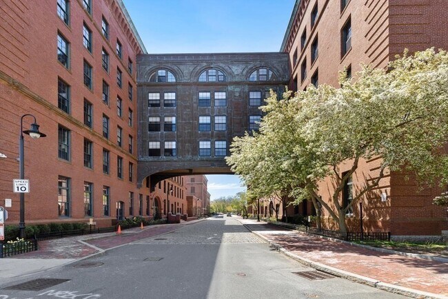
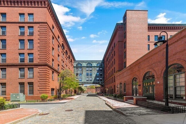
1241-1255 Adams St Unit B605
Boston, MA 02124
Favorites
1241-1255 Adams St Unit B605

Favorites
Check Back Soon for Upcoming Availability
| Beds | Baths | Average SF |
|---|---|---|
| 2 Bedrooms 2 Bedrooms 2 Br | 2 Baths 2 Baths 2 Ba | 1,850 SF |
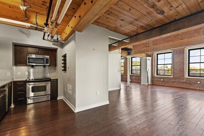
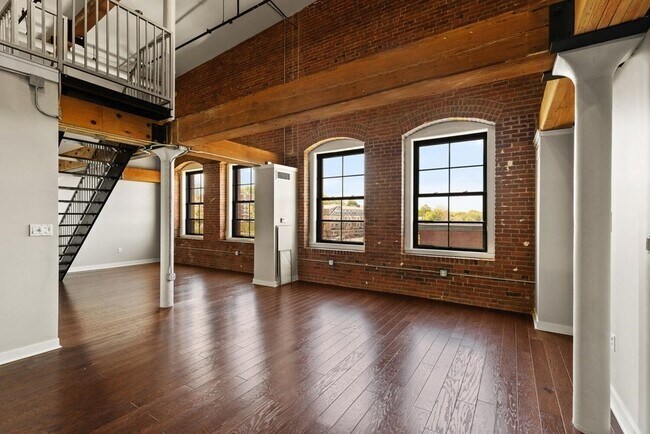
About This Property
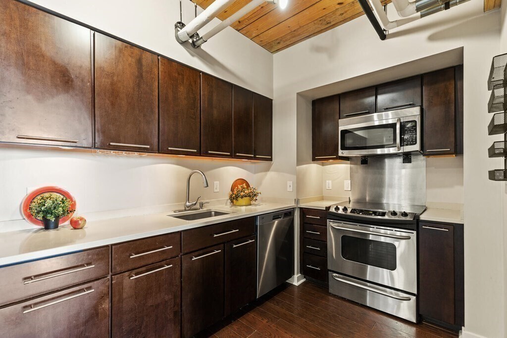
PENTHOUSE 2HAB, baths,1.850sf completa en dos levels,facing al oeste con impresionantes vistas de la puesta del sol. Nuevos pisos en ambos niveles. DOS espacios de estacionamiento al aire libre. El lugar incluyen piscina cubierta billar,gimnasio,common patio junto al río, con seating,grills,and un brasero (todos los updated). Ubicado en el pueblo de Lower Mills en el Neponset River con restaurants,steps de la MBTA/Milton stop,Star,CVS,and tiendas.
1241-1255 Adams St is a condo located in Suffolk County and the 02124 ZIP Code. This area is served by the Boston Public Schools attendance zone.
1241-1255 Adams St,
Boston,
MA
02124
West Codman Hill-West Lower Mills is located 10 miles outside of Boston. The Lower Mills District was added to the National Register of Historic Places and is home to a large industrial factory complex— once associated with the oldest producer of chocolate in the United States. For outdoor recreation, visit Roberts Playground, offering soccer fields, a basketball court, and a field hockey area. Along the southern border of town lies the Neponset River, where residents have access to trails for biking and running.
Contemporary and Colonial-style houses are popular in the area.
Learn more about living in West Codman Hill-West Lower MillsBelow are rent ranges for similar nearby apartments
| Beds | Average Size | Lowest | Typical | Premium |
|---|---|---|---|---|
| Studio Studio Studio | 5266-5271 Sq Ft | $1,995 | $2,222 | $2,536 |
| 1 Bed 1 Bed 1 Bed | 4155-4183 Sq Ft | $1,300 | $2,453 | $2,850 |
| 2 Beds 2 Beds 2 Beds | 925-950 Sq Ft | $2,300 | $3,560 | $8,475 |
| 3 Beds 3 Beds 3 Beds | 1724 Sq Ft | $2,850 | $3,389 | $4,700 |
| 4 Beds 4 Beds 4 Beds | 726 Sq Ft | $1,510 | $2,920 | $3,800 |
Expenses
Utilities Included
Gas, Water, Trash Removal
Included
Education
| Colleges & Universities | Distance | ||
|---|---|---|---|
| Colleges & Universities | Distance | ||
| Drive: | 11 min | 4.5 mi | |
| Drive: | 9 min | 4.6 mi | |
| Drive: | 10 min | 5.7 mi | |
| Drive: | 11 min | 6.1 mi |
1241-1255 Adams St Unit B605 is within 11 minutes or 4.5 miles from Curry College. It is also near UMass Boston and Wentworth Inst. of Technology.
Schools


Public Elementary, Middle & High School
Grades K-12
605 Students
Nearby
Public Elementary & Middle School
Grades PK-8
467 Students
Nearby
Private Elementary & Middle School
Grades PK-8
Nearby
Private Elementary, Middle & High School
Grades K-12
997 Students
Nearby
Private High School
Grades 9-12
95 Students
Nearby
School data provided by
 The GreatSchools Rating helps parents compare schools within a state based on a variety of school quality indicators and provides a helpful picture of how effectively each school serves all of its students. Ratings are on a scale of 1 (below average) to 10 (above average) and can include test scores, college readiness, academic progress, advanced courses, equity, discipline and attendance data. We also advise parents to visit schools, consider other information on school performance and programs, and consider family needs as part of the school selection process.
View GreatSchools Rating Methodology
Data provided by GreatSchools.org © 2026. All rights reserved.
View GreatSchools Rating Methodology
Data provided by GreatSchools.org © 2026. All rights reserved.
Transportation options available in Boston include Milton Station, located 0.2 mile from 1241-1255 Adams St Unit B605. 1241-1255 Adams St Unit B605 is near General Edward Lawrence Logan International, located 10.0 miles or 17 minutes away.
| Transit / Subway | Distance | ||
|---|---|---|---|
| Transit / Subway | Distance | ||
|
|
Walk: | 4 min | 0.2 mi |
|
|
Walk: | 7 min | 0.4 mi |
|
|
Walk: | 8 min | 0.4 mi |
|
|
Walk: | 15 min | 0.8 mi |
|
|
Walk: | 17 min | 0.9 mi |
| Commuter Rail | Distance | ||
|---|---|---|---|
| Commuter Rail | Distance | ||
|
|
Drive: | 2 min | 1.1 mi |
| Drive: | 4 min | 1.9 mi | |
| Drive: | 5 min | 2.2 mi | |
|
|
Drive: | 7 min | 3.4 mi |
| Drive: | 6 min | 3.5 mi |
| Airports | Distance | ||
|---|---|---|---|
| Airports | Distance | ||
|
General Edward Lawrence Logan International
|
Drive: | 17 min | 10.0 mi |
Walkability Near 1241-1255 Adams St Boston, MA 02124
Getting Around
 What do Walkability, Transit, Drivability, and Bikeability mean?
Walkability measures the walking distance to day-to-day needs.
Transit measures access to public transportation.
Drivability measures congestion, parking availability, and access to major roads.
Bikeability measures the suitability for cycling.
How It Works
What do Walkability, Transit, Drivability, and Bikeability mean?
Walkability measures the walking distance to day-to-day needs.
Transit measures access to public transportation.
Drivability measures congestion, parking availability, and access to major roads.
Bikeability measures the suitability for cycling.
How It Works
Moderately Walkable
Walkability
60
/ 100
Some Public Transit
Transit
50
/ 100
Exceptionally Drivable
Drivability
100
/ 100
Moderately Bikeable
Bikeability
70
/ 100
Scores provided by
-
Soundscore™
-
/ 100
Traffic
-Airport
-Businesses
-Scores provided by
HowLoud What is a Sound Score Rating? A Sound Score Rating aggregates noise caused by vehicle traffic, airplane traffic and local sources. How It WorksTime and distance from 1241-1255 Adams St Unit B605.
| Shopping Centers | Distance | ||
|---|---|---|---|
| Shopping Centers | Distance | ||
| Walk: | 8 min | 0.4 mi | |
| Drive: | 3 min | 1.2 mi | |
| Drive: | 4 min | 1.9 mi |
1241-1255 Adams St Unit B605 has 3 shopping centers within 1.9 miles, which is about a 4-minute drive. The miles and minutes will be for the farthest away property.
| Parks and Recreation | Distance | ||
|---|---|---|---|
| Parks and Recreation | Distance | ||
|
Mass Audubon's Boston Nature Center and Wildlife Sanctuary
|
Drive: | 5 min | 2.4 mi |
|
Franklin Park Zoo
|
Drive: | 5 min | 3.0 mi |
|
Lower Neponset River Trail
|
Drive: | 5 min | 3.1 mi |
|
Squantum Point Park
|
Drive: | 9 min | 3.9 mi |
|
Dorchester Shores Reservation
|
Drive: | 9 min | 4.6 mi |
1241-1255 Adams St Unit B605 has 5 parks within 4.6 miles, including Mass Audubon's Boston Nature Center and Wildlife Sanctuary, Franklin Park Zoo, and Lower Neponset River Trail.
| Hospitals | Distance | ||
|---|---|---|---|
| Hospitals | Distance | ||
| Walk: | 9 min | 0.5 mi | |
| Drive: | 3 min | 1.8 mi | |
| Drive: | 8 min | 4.8 mi |
1241-1255 Adams St Unit B605 has 3 hospitals within 4.8 miles, the nearest is Carney Hospital which is 0.5 mile away and a 9 minute walk.
| Military Bases | Distance | ||
|---|---|---|---|
| Military Bases | Distance | ||
| Drive: | 33 min | 19.2 mi | |
| Drive: | 40 min | 23.7 mi | |
| Drive: | 42 min | 24.7 mi |
1241-1255 Adams St Unit B605 has 3 military bases within 24.7 miles, the nearest is US Military Reservation which is 19.2 miles away and a 33 minute drive.
You May Also Like
Similar Rentals Nearby


What Are Walk Score®, Transit Score®, and Bike Score® Ratings?
Walk Score® measures the walkability of any address. Transit Score® measures access to public transit. Bike Score® measures the bikeability of any address.
What is a Sound Score Rating?
A Sound Score Rating aggregates noise caused by vehicle traffic, airplane traffic and local sources.
1241-1255 Adams St
Boston, MA 02124