
$1,200
/ Month
1233 S Clark St
New Orleans, LA 70125
Today
|
Edit
Favorites
504-507-0507
-
Bedrooms
1
-
Bathrooms
1
-
Square Feet
580 sq ft
-
Available
Available Nov 21
1233 S Clark St

Favorites
About This Home
$1,200 deposit,
Available Nov 21
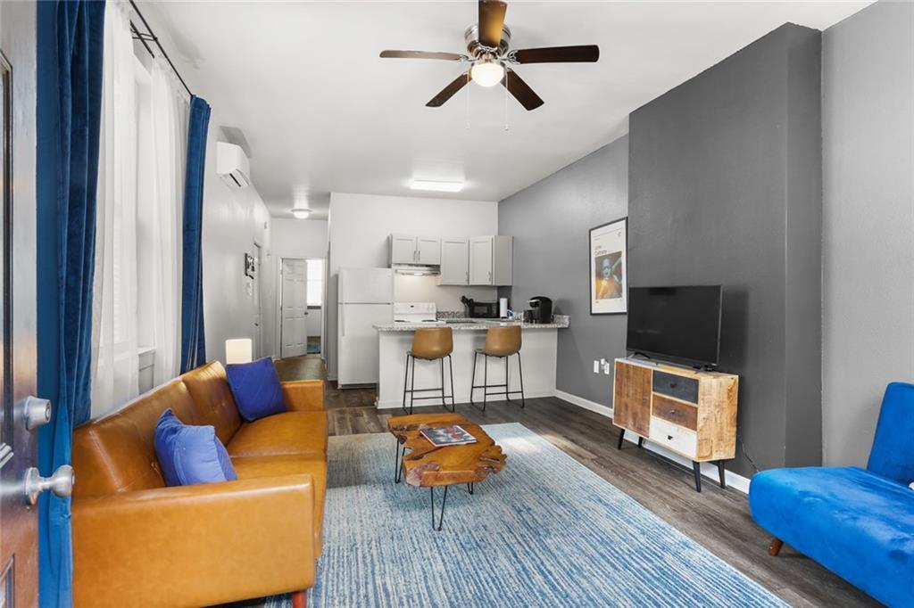
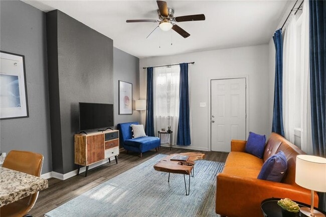
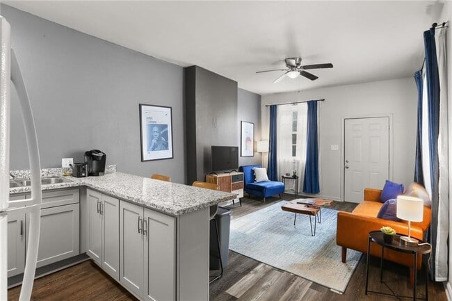
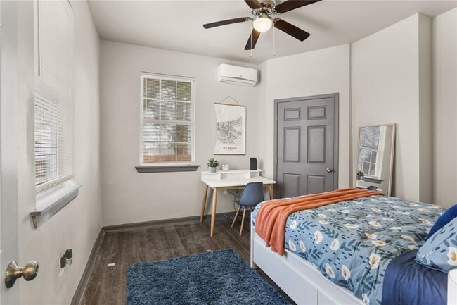
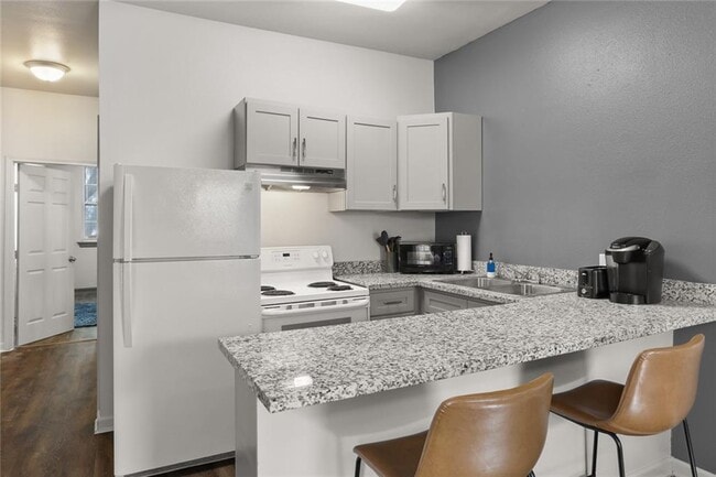
Welcome home to this beautifully updated 1 bedroom / 1 bathroom apartment in a classic New Orleans double! Recently renovated with granite countertops, updated flooring, and a refreshed kitchen and bathroom, this space combines charm with modern comfort. Stay cool in the summer and cozy in the winter with energy-efficient mini-split A/C and heat. The unit offers 580 sqft of easy living space, perfect for professionals, students, or anyone who wants quick access to the city. Located in one of the most convenient spots in town, you’ll be minutes from Downtown, Mid-City, Uptown, I-10, and the Earhart Expressway, making commutes and city life a breeze. Features: • 1 spacious bedroom, 1 full bathroom • Modern kitchen with granite countertops • Energy-efficient ductless A/C & heating • Easy street parking • Prime location near downtown & expressways Rent: $1,200/month Utilities included: Water Move-In Data November 21, make this cozy space your next home! *Will Be Unfurnished*
1233 S Clark St is a house located in Orleans County and the 70125 ZIP Code. This area is served by the Orleans Parish attendance zone.
* Price shown is base rent. Excludes user-selected optional fees and variable or usage-based fees and required charges due at or prior to move-in or at move-out. Price, availability, fees, and any applicable rent special are subject to change without notice.
* Square footage definitions vary. Displayed square footage is approximate.
Fees and Policies
The fees below are based on community-supplied data and may exclude additional fees and utilities.
- One-Time Basics
- Due at Move-In
- Security Deposit - Refundable$1,200
- Due at Move-In
Property Fee Disclaimer: Based on community-supplied data and independent market research. Subject to change without notice. May exclude fees for mandatory or optional services and usage-based utilities.
House Features
- Washer/Dryer
- Washer/Dryer Hookup
Contact
- Listed by Andy Martinez
- Phone Number
- Contact
Location
Get Directions
Amenities
- Washer/Dryer
- Washer/Dryer Hookup
Part of New Orleans' 16th Ward, Gert Town is more of a "college town." This is the location of Xavier University, a private liberal arts college opened by the Catholic Church in 1915. This prestigious, historically black university ranks as one of the nation's best.
Gert Town extends west of I-10 between B.W. Cooper to the south and Holly Grove to the north. It loosely follows Earhart Boulevard on the west end. The neighborhood has a unique street pattern, with the streets crossing and curving like the currents of the river. Since this was the swampy "back end" of New Orleans, most streets stopped before reaching Gert Town, which was uninhabited. Later, when canals helped to drain this low-lying area, Gert Town became a railroad hub. The roads were extended into Gert Town from other areas, often running into each other and creating the odd flow.
Today, Gert Town is a dynamic community located about four miles northwest of the French Quarter.
Learn more about living in Gert Town
Education
| Colleges & Universities | Distance | ||
|---|---|---|---|
| Colleges & Universities | Distance | ||
| Walk: | 9 min | 0.5 mi | |
| Drive: | 6 min | 2.0 mi | |
| Drive: | 4 min | 2.0 mi | |
| Drive: | 5 min | 2.3 mi |
1233 S Clark St is within 9 minutes or 0.5 mile from Xavier Univ of La, New Orleans. It is also near Tulane University, New Orleans and LSU Health Center, Downtown.
Schools


Charter Elementary & Middle School
Grades PK-8
745 Students
Attendance Zone
Charter Elementary & Middle School
Grades PK-8
747 Students
Attendance Zone
Public High School
Grades 9-12
Attendance Zone
Private Elementary & Middle School
Grades PK-7
216 Students
Nearby
Private Middle & High School
Grades 6-12
Nearby
School data provided by
 The GreatSchools Rating helps parents compare schools within a state based on a variety of school quality indicators and provides a helpful picture of how effectively each school serves all of its students. Ratings are on a scale of 1 (below average) to 10 (above average) and can include test scores, college readiness, academic progress, advanced courses, equity, discipline and attendance data. We also advise parents to visit schools, consider other information on school performance and programs, and consider family needs as part of the school selection process.
View GreatSchools Rating Methodology
Data provided by GreatSchools.org © 2025. All rights reserved.
View GreatSchools Rating Methodology
Data provided by GreatSchools.org © 2025. All rights reserved.
Transportation options available in New Orleans include Canal And Jefferson Davis Pkwy, located 1.4 miles from 1233 S Clark St. 1233 S Clark St is near Louis Armstrong New Orleans International, located 13.2 miles or 20 minutes away.
| Transit / Subway | Distance | ||
|---|---|---|---|
| Transit / Subway | Distance | ||
|
|
Drive: | 3 min | 1.4 mi |
|
|
Drive: | 3 min | 1.4 mi |
|
|
Drive: | 3 min | 1.4 mi |
|
|
Drive: | 4 min | 1.6 mi |
|
|
Drive: | 4 min | 1.6 mi |
| Commuter Rail | Distance | ||
|---|---|---|---|
| Commuter Rail | Distance | ||
|
|
Drive: | 6 min | 2.4 mi |
|
|
Drive: | 42 min | 34.3 mi |
| Airports | Distance | ||
|---|---|---|---|
| Airports | Distance | ||
|
Louis Armstrong New Orleans International
|
Drive: | 20 min | 13.2 mi |
Time and distance from 1233 S Clark St.
| Shopping Centers | Distance | ||
|---|---|---|---|
| Shopping Centers | Distance | ||
| Walk: | 14 min | 0.8 mi | |
| Drive: | 3 min | 1.2 mi | |
| Drive: | 3 min | 1.4 mi |
1233 S Clark St has 3 shopping centers within 1.4 miles, which is about a 3-minute walk. The miles and minutes will be for the farthest away property.
| Parks and Recreation | Distance | ||
|---|---|---|---|
| Parks and Recreation | Distance | ||
|
Longue Vue House and Gardens
|
Drive: | 5 min | 2.3 mi |
|
New Orleans Botanical Garden
|
Drive: | 7 min | 2.8 mi |
|
Louisiana Children's Museum
|
Drive: | 7 min | 3.0 mi |
|
New Orleans City Park
|
Drive: | 8 min | 3.4 mi |
|
New Orleans Jazz National Historical Park
|
Drive: | 9 min | 3.6 mi |
1233 S Clark St has 5 parks within 3.6 miles, including Longue Vue House and Gardens, Louisiana Children's Museum, and New Orleans Botanical Garden.
| Hospitals | Distance | ||
|---|---|---|---|
| Hospitals | Distance | ||
| Drive: | 5 min | 2.1 mi | |
| Drive: | 6 min | 2.5 mi | |
| Drive: | 5 min | 2.7 mi |
1233 S Clark St has 3 hospitals within 2.7 miles, the nearest is University Medical Center New Orleans which is 2.1 miles away and a 5 minute drive.
| Military Bases | Distance | ||
|---|---|---|---|
| Military Bases | Distance | ||
| Drive: | 13 min | 6.9 mi |
1233 S Clark St is 6.9 miles and a 13 minute drive from New Orleans Naval Support.
You May Also Like
Similar Rentals Nearby


What Are Walk Score®, Transit Score®, and Bike Score® Ratings?
Walk Score® measures the walkability of any address. Transit Score® measures access to public transit. Bike Score® measures the bikeability of any address.
What is a Sound Score Rating?
A Sound Score Rating aggregates noise caused by vehicle traffic, airplane traffic and local sources

1233 S Clark St
New Orleans, LA 70125